Mòruisg facts for kids
Quick facts for kids Mòruisg |
|
|---|---|

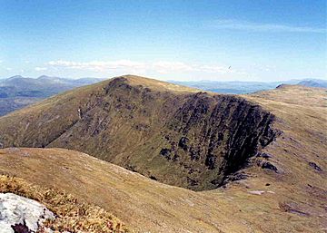
Mòruisg seen from Sgùrr nan Ceannaichean across Coire Toll nan Bian.
|
|
| Highest point | |
| Elevation | 928 m (3,045 ft) |
| Prominence | 594 m (1,949 ft) |
| Parent peak | Sgurr a' Choire Ghlais |
| Listing | Munro, Marilyn |
| Naming | |
| English translation | Big Water |
| Language of name | Gaelic |
| Pronunciation | English approximation: MOR-uushk |
| Geography | |
| Location | Wester Ross, Scotland |
| Parent range | Northwest Highlands |
| OS grid | NH101500 |
| Topo map | OS Landranger 25, OS Explorer 429 |
Mòruisg is a mountain in Scotland. It is found in the Glencarron and Glenuig Forest. This mountain is about 10 kilometres southwest of the village of Achnasheen. It is located in the Highland area.
Contents
About Mòruisg Mountain
Mòruisg stands tall at 928 metres (3044 feet). It is one of the easier Munros to reach in the Glen Carron area. A Munro is a Scottish mountain over 3,000 feet (914.4 metres) high. The mountain is only three kilometres from the A890 road. This road runs through the glen, which is a narrow valley.
Its name, Mòruisg, comes from Scottish Gaelic. It means “Big Water”. This name might seem a bit odd. The mountain only has two small lochs, which are lakes. These lochs are found in the corries to the north. A corrie is a bowl-shaped hollow on a mountainside.
Exploring Mòruisg's Features
Mòruisg is a long mountain with steep sides. Its top is a wide, flat area. This flat top has many small bumps and cairns. Cairns are piles of stones used as markers. Because of these, it can be tricky to find the very highest point. This is especially true when it's misty.
The northern corrie is called Corrie na Glas-lic. It holds the two small lochs, Loch Cnoc na Mointeich and Loch Coireag nan Mang. To the north and west, the slopes drop steeply into Glen Carron. The southern sides are very steep. They fall into the valley of the Allt a’ Chonais. This valley has a path leading to Glenuaig Lodge.
In 1981, a nearby mountain, Sgùrr nan Ceannaichean, became a Munro too. This made Mòruisg more popular for hikers. Many people now enjoy a circular walk. This walk goes along the edge of Coire Toll nan Bian. This beautiful corrie sits between the two mountains.
Climbing Mòruisg
You can start climbing Mòruisg from the A890 road in Glen Carron. There is a parking spot about one kilometre west of Loch Sgamhain. You first cross the River Carron using a footbridge. Then, it's a steep climb of almost 800 metres to the top. The path goes through heather and scree, which are loose rocks.
Most people who climb Mòruisg also climb Sgùrr nan Ceannaichean. This makes for a longer and more interesting hike. There are also paths from the south. One path goes up Sgùrr nan Ceannaichean first. Then it continues to Mòruisg. Another path starts at Glenuaig Lodge. It climbs the steep southern slopes directly to the top of Mòruisg.
Amazing Views from the Top
Mòruisg offers fantastic views. It is surrounded by deep glens, which are valleys. This means it stands out from the land around it. From the top, you can see the distant mountains north of Loch Monar. You can also see the other Glen Carron mountains to the west.
 | Jackie Robinson |
 | Jack Johnson |
 | Althea Gibson |
 | Arthur Ashe |
 | Muhammad Ali |

