Loch Scaven facts for kids
Quick facts for kids Loch Scaven |
|
|---|---|
| Loch Sgamhain | |

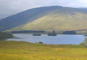
Loch Scaven looking west
|
|
| Location | Wester Ross, Scotland |
| Coordinates | 57°31′31″N 5°10′35″W / 57.52528°N 5.17639°W |
| Type | freshwater loch |
| Primary inflows | River Carron |
| Primary outflows | River Carron |
| Basin countries | Scotland |
| Max. length | 1 mi (1.6 km) |
| Max. width | 0.33 mi (0.53 km) |
| Surface area | 58.7 ha (145 acres) |
| Average depth | 27 ft (8.2 m) |
| Max. depth | 72 ft (22 m) |
| Water volume | 165,000,000 cu ft (4,700,000 m3) |
| Shore length1 | 4.6 km (2.9 mi) |
| Surface elevation | 152 m (499 ft) |
| Islands | 2 islets |
| 1 Shore length is not a well-defined measure. | |
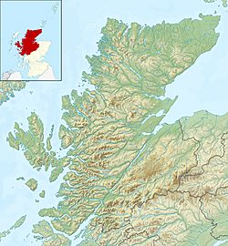
Loch Scaven (in Gaelic: Loch Sgamhain) is a beautiful freshwater loch located in Wester Ross, Scotland. It sits at the very start of Glen Carron, close to where the River Carron begins its journey. This loch is about 4 miles (6.4 km) southwest of a place called Achnasheen and 2 miles (3.2 km) from Loch Gowan.
Contents
What is a Loch?
A loch is the Scottish word for a lake or a sea inlet. Loch Scaven is a freshwater loch, meaning it's a body of fresh water surrounded by land, just like a lake. Scotland is famous for its many lochs, which are often found in stunning natural landscapes.
Geography and Features
Loch Scaven stretches out from the northeast to the southwest. Its shoreline is quite simple, meaning it doesn't have too many complicated curves or bays.
Cnoc nan Sguad
At the western end of the loch, there's a special piece of land that sticks out into the water. This is called a 'promontory', and its name is 'Cnoc nan Sguad'. It's located on the northern side of the loch.
Islands in the Loch
Right in the middle of Loch Scaven, across from Cnoc nan Sguad, you can find two small islands. These tiny landmasses add to the natural beauty of the loch.
The River Carron
The River Carron is very important to Loch Scaven. It flows into the loch and then flows out again, carrying water through the landscape. This means Loch Scaven is a part of the river's journey, helping to regulate its flow.
Exploring the Loch's Depths
Loch Scaven has been studied by scientists to learn more about its size and depth. On August 8, 1902, two researchers named R.M. Clark and James Murray carefully surveyed the loch.
The Bathymetrical Survey
Their work was part of a much bigger project called the Bathymetrical Survey of Fresh-Water Lochs of Scotland 1897-1909. This huge survey was led by Sir John Murray and Laurence Pullar. A "bathymetrical survey" is like making a detailed map of the bottom of a lake or ocean. Scientists use special tools to measure how deep the water is everywhere, creating a chart that shows the underwater landscape. This helps us understand the loch's shape, how much water it holds, and even what kind of creatures might live there.
 | James Van Der Zee |
 | Alma Thomas |
 | Ellis Wilson |
 | Margaret Taylor-Burroughs |


