Loch Alsh facts for kids
Quick facts for kids Loch Alsh |
|
|---|---|

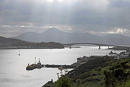
The Kyle (narrows) of Loch Alsh and the Skye Bridge
|
|
| Location | Wester Ross, Highland Region, Scotland |
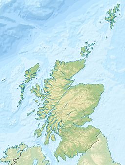
| Coordinates | 57°16′N 5°40′W / 57.27°N 5.66°W |
| Lake type | Sea loch |
| Primary inflows | Loch Long (Highlands), Loch Duich |
| Primary outflows | Inner Sound, Scotland |
| Basin countries | Scotland |
| Max. length | 12 km (7.5 mi) |
| Max. width | 2.5 km (1.6 mi) |
| Surface elevation | 0 m (0 ft) |
| Settlements | Kyle of Lochalsh, Ardelve, Balmacara |
Loch Alsh (which means "foaming lake" in Scottish Gaelic) is a sea inlet in Scotland. It sits between the Isle of Skye (part of the Inner Hebrides) and the Northwest Highlands on the mainland.
The name Loch Alsh can also refer to the land around the loch. This area is full of history and is becoming a popular place for tourists to visit. The land around Loch Alsh is hilly and has a mild, wet climate. You can find some grassy areas and woodlands, but much of it is open moorland. The rocks here are very old, some of the oldest in the world!
Where is Loch Alsh?
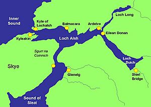
Loch Alsh stretches inland for about 12 kilometres (7.5 miles) from the town of Kyle of Lochalsh to Ardelve. From Ardelve, two other lochs branch off. Loch Duich continues southeast for another 10 km (6 mi) towards Shiel Bridge. Loch Long goes deeper into the mountains to the northeast.
A narrow passage from the south of Loch Alsh connects to the Sound of Sleat. This sound separates the Isle of Skye from the mainland. The loch is overlooked by Sgùrr na Coinnich, a mountain on Skye that rises to 739 metres (2,425 ft). On the mainland, the hills to the north reach 452 m (1,483 ft) at Auchtertyre Hill.
The climate here is mild. It rains a lot, about 2,300 mm (91 in) each year. Temperatures usually range from 0–7 °C (32–45 °F) in January to 10–18 °C (50–64 °F) in July and August. It's quite common for it to rain on any given day.
Much of the countryside is moorland (open, uncultivated land) or pasture (land for grazing animals). However, there are also areas of deciduous forests with native birch and oak trees. You can also find some conifer tree plantations. Long ago, there were more forests. But early inhabitants cleared some land for crofts (small farms). Later, during the Highland Clearances, many crofts were destroyed, and the land became pasture.
Loch Alsh was also the site of the last invasion of the UK by Spanish forces in 1719.
Ancient Rocks and Landforms
The area around Loch Alsh has very old rocks. These rocks, called Lewisian gneisses, formed about 2,800 million years ago! They are some of the oldest rocks on Earth. Over millions of years, these ancient metamorphic rocks have been worn down. The most recent changes happened during a series of ice ages, when huge glaciers carved out the landscape.
Amazing Sea Creatures
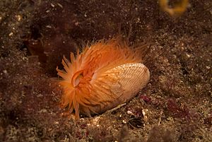
In 2012, scientists made an exciting discovery in Loch Alsh. They found a huge group of flame shells! These are small, colorful shellfish that build nests on the seabed. This discovery was made during a survey by Heriot-Watt University for Marine Scotland.
This amazing reef is thought to have over 100 million flame shells. It covers an area of 75 hectares (190 acres), making it the largest known flame shell reef in the UK! To protect these special flame shell beds, Loch Alsh became a Nature Conservation Marine Protected Area (NCMPA) in 2014. This means the area is now protected to help these creatures and their habitat thrive.
 | Selma Burke |
 | Pauline Powell Burns |
 | Frederick J. Brown |
 | Robert Blackburn |


