
Eilean Donan facts for kids
| Gaelic name | Eilean Donnain |
|---|---|
| Meaning of name | Island of Donnán |
 Eilean Donan Castle |
|
| OS grid reference | NG880260 |
| Coordinates | 57°16′26.50″N 05°30′58″W / 57.2740278°N 5.51611°W |
| Physical geography | |
| Island group | Loch Duich |
| Highest elevation | 3 m (10 ft) |
| Administration | |
| Sovereign state | United Kingdom |
| Country | Scotland |
| Council area | Highland |
| Demographics | |
| Population | 0 |
Eilean Donan (which means "island of Donnán" in Scottish Gaelic) is a small island in the western Highlands of Scotland. It sits where three sea lochs meet: Loch Duich, Loch Long, and Loch Alsh. The island is about 1 kilometer (0.6 miles) from the village of Dornie.
A footbridge built in the early 1900s connects the island to the mainland. Eilean Donan is famous for its beautiful castle, which you often see in photos, movies, and TV shows. The first castle was built here in the 1200s. It became a strong base for the Clan Mackenzie and their friends, the MacRaes. In 1719, government ships destroyed the castle because the Mackenzies were involved in the Jacobite rebellions. The castle you see today was rebuilt in the 1900s by Lieutenant-Colonel John MacRae-Gilstrap.
Eilean Donan is part of the Kintail National Scenic Area, one of Scotland's special protected places. In 2001, only one person lived on the island, but by 2011, no one lived there permanently. The island is named after Donnán of Eigg, a Celtic saint who died in 617. People believe Donnán built a church on the island, but no signs of it remain today.
History of Eilean Donan Castle
It's possible that a very early Christian settlement was on the island in the 500s or 600s. This settlement might have been dedicated to Saint Donnán. No old Christian buildings are left. However, pieces of stone that have been heated to very high temperatures have been found. This suggests there was a fort on the island during the Iron Age or early Middle Ages.
Building the First Castle
Around the early 1200s, during the time of King Alexander II, a large castle wall was built. This wall surrounded most of the island. At this time, the area was a border between the Norse-Celtic Lordship of the Isles and the Earldom of Ross. Eilean Donan was a great spot to defend against attacks from the Norse.
A story says that the son of a Matheson chief could talk to birds. Because of this power, he gained wealth and respect from King Alexander II. The king then asked him to build the castle to protect his kingdom.
Later, the island became a stronghold for the Mackenzies of Kintail. The Macraes and Maclennans were said to have guarded the castle for the Mackenzies. These clans later became very close to the Mackenzies. Mackenzie clan stories say that Robert the Bruce stayed at Eilean Donan in the winter of 1306 to 1307. The castle was not involved in other events during the Wars of Scottish Independence.
In 1331, Thomas Randolph, 1st Earl of Moray, visited the castle. Before his arrival, some people who had broken the law were dealt with. By the mid-1300s, the Mackenzies were having conflicts with the Earls of Ross. The Macraes began to settle in Kintail and became trusted by the Mackenzie chiefs. They even became known as "Mackenzie's shirt of mail" because they acted as their bodyguards.
Clan Conflicts at the Castle

King James I wanted to bring peace to the Highlands. In 1427, he invited the main chiefs to meet him. Alexander Mackenzie of Kintail, the young 6th Earl of Kintail, was supposedly among them. King James arrested him and other chiefs. Alexander was sent to school in Perth because he was so young. His uncles tried to take control of Kintail, but the castle's guard, Duncan Macaulay, held Eilean Donan for Alexander.
Alexander later supported the king against the MacDonald Lords of the Isles. He was rewarded with more land in Kintail in 1463. Alexander died around 1488. His son, Kenneth Mackenzie, 7th of Kintail, then won the Battle of Blar Na Pairce against the MacDonalds.
In 1503, Alexander Gordon, 3rd Earl of Huntly, offered to give Eilean Donan to the king. He would then hold it for the king. King James IV even sent a ship to help. Eventually, John of Killin, a Mackenzie chief, took control of the castle. Christopher Macrae was appointed as the new guard around 1511.
In 1539, Donald Gorm Macdonald of Sleat attacked the Mackenzie lands. He then learned that Eilean Donan was not well-guarded and launched a surprise attack. Only two people were in the castle. Duncan MacGillechriosd of the Clan Macrae arrived and fought the MacDonalds. He managed to hit Donald Gorm with his last arrow, seriously injuring him. The MacDonalds then left.
Duncan MacGillechriosd's son, Christopher Macrae, later became the castle's guard. He held the castle during another clan conflict, this time between the Mackenzies and the MacDonalds of Glengarry. This fighting lasted for almost 25 years. Around 1602, Eilean Donan was used as a base for a sea battle.
The 1600s at the Castle

The Rev. Farquhar Macrae, son of Christopher Macrae, was born at the castle in 1580. He became the castle's guard and minister of Kintail in 1618. Colin Mackenzie, 1st Earl of Seaforth, became an Earl in 1623. He often visited Eilean Donan. The castle guard had to host him and his large group of followers. In 1635, the 2nd Earl of Seaforth made Farquhar the tutor for his six-year-old son, Kenneth. Kenneth was then raised at Eilean Donan.
During the civil wars in the mid-1600s, the Earl of Seaforth supported King Charles I. In 1650, after the king was executed, the Scottish Parliament sent soldiers to Eilean Donan. The local people did not like these soldiers. When the soldiers tried to get supplies, a fight broke out, and the soldiers were forced away. Soon after, the soldiers left.
The castle was briefly taken over by the Earl of Balcarres and his wife. They were in the Highlands supporting a royalist uprising. In June 1654, General Monck, who was Oliver Cromwell's military governor in Scotland, marched through Kintail. His troops caused a lot of damage.
Jacobite Uprising and Castle's Destruction
In 1689, King James VII lost his throne. The crown was offered to William of Orange in what was called the "Glorious Revolution". This also made Presbyterianism the main religion in Scotland. However, many people in the Highlands remained Roman Catholic and stayed loyal to the Stuarts.
This led to several Jacobite uprisings. Government forces increased their presence in Scotland. In 1714, a military engineer named Lewis Petit drew the only known picture of Eilean Donan before its destruction. It showed a castle that was mostly in ruins, with only a small building near the entrance still having a roof.
A big Jacobite uprising happened in 1715. It was an attempt to bring back James Francis Edward Stuart, the "Old Pretender," to the throne. William Mackenzie, 5th Earl of Seaforth, joined the Jacobite army. The Macraes gathered at Eilean Donan. They are said to have danced on the castle roof before heading to the Battle of Sheriffmuir. Many Macraes died in this battle. The uprising failed soon after.
After the 1715 uprising, the Jacobites got help from Spain. In April 1719, 300 Spanish soldiers arrived in Loch Duich and took over Eilean Donan Castle. However, the expected uprising of Highlanders did not happen. The main Spanish invasion force never arrived.
In early May, the Royal Navy sent ships to the area. On May 10, 1719, three British ships, HMS Worcester, HMS Flamborough, and HMS Enterprise, anchored near Eilean Donan. They sent a boat to talk, but the Spanish soldiers fired at it. All three ships then fired their cannons at the castle for over an hour. The next day, the bombing continued. A landing party went ashore and captured the castle with little resistance. The castle was then destroyed using gunpowder. The Spanish prisoners were taken to Edinburgh. The remaining Spanish troops were defeated on June 10 at the Battle of Glen Shiel.
Rebuilding and Modern Use

Between 1919 and 1932, Lieutenant Colonel John MacRae-Gilstrap rebuilt the castle. He also built an arched bridge to make it easier to reach the island. Macrae-Gilstrap also created a war memorial for the MacRae clan members who died in the First World War. This memorial has lines from John McCrae's poem "In Flanders Fields".
Eilean Donan opened to the public in 1955. It has become a very popular place to visit. In 2009, over 314,000 people visited it, making it one of Scotland's most visited castles. In 1983, the castle was given to the Conchra Charitable Trust. This trust was set up by the Macrae family to keep the castle in good condition. A special visitor center was opened in 1998.

Eilean Donan Castle is often called one of the most photographed places in Scotland. It is a well-known Scottish symbol. You can often see it on packaging for shortbread, whisky, and other products. The castle has appeared in many films, starting with Bonnie Prince Charlie in 1948. It was also featured in Highlander (1986) as the home of Clan MacLeod. It was a backdrop for a dance scene in the Bollywood movie Kuch Kuch Hota Hai in 1998. In 1999, it was used as the Scottish headquarters for MI6 in The World Is Not Enough.
How the Castle Changed Over Time
Eilean Donan Castle changed a lot from its first defenses in the 1200s until it was destroyed in 1719. Then it was rebuilt in the 1900s. The first castle had a wall around most of the island. A tower house was added later. In the 1300s or 1400s, the outer wall was left, and a smaller area was built around the tower house. More buildings were added in the 1500s. The castle was almost completely destroyed in 1719. It took nearly 200 years before rebuilding began.
It's hard to know exactly what the early castle looked like. Many old parts were lost during the rebuilding. Not much historical information about its early days survives. A mapmaker named Timothy Pont (who lived from about 1565–1614) described it:
The castell of Ylen Donen is composed of a strong and fair dungeon [a donjon or keep] upon a rock, with another tower compasd with a fair barmkin wall, with orchards and trees, al within ane yland of the lenth of twa pair of butts [[[archery butts]]] almost round. It is sayd of old that castel consisted of seven tours.
The only drawing of the castle before it was destroyed was made in 1714 by Lewis Petit. He was a military engineer who surveyed defenses in Scotland. His drawings show that the castle was mostly in ruins by then. Only one building in the southeast corner still had a roof.


The First Castle Walls
In the 1200s, a large wall was built around the island. This wall enclosed most of the land above the high tide line. You can still see small parts of these walls today. They ran around the northern part of the island. The eastern and southern parts of this wall are hidden by later buildings. The area inside the wall was about 3,000 square meters (32,000 sq ft).
At the northern tip of the wall, the foundations of a large tower remain. It measured about 12 by 13 meters (39 by 43 ft). There might have been more towers at the northeast and southwest corners. You could enter the castle through a gate in the northwest wall. A small beach there would have allowed boats to land. Another beach to the southwest might have been a second entrance. Digs in 2008 and 2009 found these walls. They also found proof that metalworking happened in the northern part of the castle.
A tower house or keep was built against the main wall. This was at the highest point of the island, probably in the 1300s. The tower was 16.5 by 12.4 meters (54 ft 2 in by 40 ft 8 in). Its walls were 3 meters (9 ft 10 in) thick. The ground floor was originally split into two rooms. Stairs in the north wall led to the hall on the first floor. There were probably two more floors above this.
The Smaller Castle
At some point, probably in the late 1300s or early 1400s, the outer wall was left behind. A smaller defensive area was built instead, about 25 meters (82 ft) square. The entrance to this smaller courtyard was from the east. We don't know why this change happened. However, a smaller area would have been easier to defend.
During the 1500s, two buildings were added to the southern edge of this smaller area. A small house was built in the southeast corner. It had a round stair-tower on its north side. This tower led to the walkway along the eastern wall. This house was likely for the castle's guard. It is the only building shown with a roof in Petit's drawing. In the southwest corner, an L-shaped building was put up. This might have been as late as the early 1600s.
The Hornwork Entrance

In the late 1500s, the castle was made bigger towards the east. This created a strong entrance area called a "hornwork". The hornwork has two walls that form a triangular courtyard. This connects the castle's east wall to a six-sided (or seven-sided) building. This building is 11.5 meters (37 ft 9 in) across. It has a well at its lowest level, 5 meters (16 ft) across and 10 meters (33 ft) deep.
This building was likely the main entrance to the castle. The water-filled inside would have been crossed by a bridge that could be removed. This would have made it hard for attackers to get in. From the bridge, steps led up into the triangular courtyard. Then you would go through the gate in the east wall. The six-sided building might have had a roof and been used for cannons. In 1893, two brass guns were found when the well was cleaned. An iron gate, called a yett, was also found. It was probably in the east door to the hornwork. Today, it is on display inside the castle.
By 1714, Lewis Petit's drawing clearly showed that the castle was mostly in ruins. Only the house in the southeast corner had a roof. Four years later, the castle was completely destroyed. By 1912, very little of the castle was still standing.
The Modern Castle

The castle buildings you see today were completely rebuilt by Macrae-Gilstrap in the 1900s. He hired an architect named George Mackie Watson to design the plans. The rebuilding followed the old layout of the castle. However, the details of the modern castle are different from how it looked originally. The old drawings by Lewis Petit were not found until the rebuilding was almost finished. So, the builders had to use other, less accurate, information.
Eilean Donan is described as a "romantic reincarnation" of a castle. It's like a new version that looks old. John Gifford, who studied the building, said that the modern castle has "fussy elaboration" where it was probably simple before. He also said it removed decorations that used to be there. He described the inside as "a rubbly Edwardian stage-set for life in the Middle Ages."
Today, you enter the castle from the south. There is a modern entrance with a portcullis (a heavy gate). Above the door is a Gaelic message that means: "As long as there is a Macrae inside, there will never be a Fraser outside." This refers to a strong bond between the two clans. Above this is the coat of arms of John Macrae-Gilstrap.
The entrance leads to the courtyard. The ground level here has been lowered, showing the rock around the tower house. The buildings in the southeast part of the castle look like the old ones but are larger. In the southwest, only the southern part of the L-shaped building was rebuilt. It is now a simple three-story house. Where the northern part used to be, there is now an open platform with views over the loch. A small tower is in the northwest corner.
The main tower (keep) is the same size as the original. However, the ground floor, which used to be two rooms, is now one large room called the Billeting Hall. Above this, on the first floor, is the Banqueting Hall. It has an oak ceiling and is decorated with coats of arms and a fireplace from the 1400s. The main ceiling beams in the Banqueting Hall are from Douglas Fir trees. They were sent from British Columbia, Canada, as a gift from the Macraes of Canada. Small rooms are built into the walls and can be reached from each hall.
Gallery
-
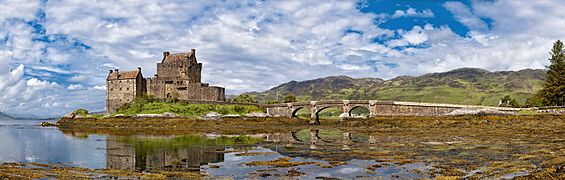
A wide view of the castle from the south.
-
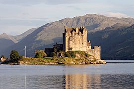
The castle, seen from the west.
-
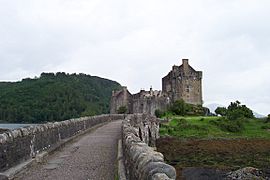
Looking down the bridge towards the castle.
-
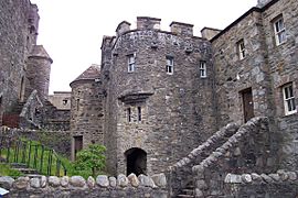
A view from inside the castle grounds.
-
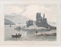
Castle Eilen Donan - a painting by William Daniell from 1818.


See also
 In Spanish: Eilean Donan para niños
