Beinn Alligin facts for kids
Quick facts for kids Beinn Alligin - Sgùrr Mhor |
|
|---|---|

Beinn Alligin
|
|
| Highest point | |
| Elevation | 986 m (3,235 ft) |
| Prominence | c. 601 m |
| Parent peak | Beinn Eighe |
| Listing | Munro, Marilyn |
| Naming | |
| English translation | Big Peak |
| Language of name | Gaelic |
| Pronunciation | |
| Geography | |
|
Lua error in Module:Location_map at line 420: attempt to index field 'wikibase' (a nil value).
|
|
| OS grid | NG865613 |
| Topo map | OS Landranger 19, 24 |
| Listed summits of Beinn Alligin | ||||
| Name | Grid ref | Height | Status | |
|---|---|---|---|---|
| Sgùrr Mhòr | NG865686 | 986 m (3,235 ft) | Munro, Marilyn | |
| Tom na Gruagaich | NG859601 | 922 m (3,025 ft) | Munro, Marilyn | |
| Na Rathanan | NG873613 | 866 m (2,841 ft) | Corbett Top | |
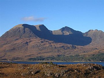
Beinn Alligin is a famous mountain in the Scottish Highlands. It is located in the beautiful Torridon region of Scotland. The name Beinn Alligin comes from Gaelic. It means Jewelled Hill. This mountain has two main peaks. Both are known as "Munros." A Munro is a Scottish mountain that is over 3,000 feet (914.4 meters) high. The two Munro peaks are Tom na Gruagaich (922 meters or 3,025 feet) to the south, and Sgùrr Mhòr (986 meters or 3,235 feet) to the north.
Beinn Alligin is part of the National Trust for Scotland's Torridon Estate. This charity has owned the land since 1967. The area is also protected as a Site of Special Scientific Interest (SSSI). This means it has special plants, animals, or geology. It is also a Special Area of Conservation (SAC). This offers even more protection for its natural habitats.
Contents
Amazing Features of Beinn Alligin
One of the most striking parts of Beinn Alligin is a huge crack in the mountain. It is called Eag Dhubh na h-Eigheachd. This means black gash of the wailing. It is also known as Leum na Caillich. This deep cut runs into the ridge south of the main summit.
The Great Rockslide
This gash was formed by a massive rockslide. It is one of the biggest rockslides in Britain. It happened about 3,750 years ago. The amount of rock that moved was huge. It was about 3.5 million cubic meters. This is like a giant natural scar on the mountain.
Local Legends and Folklore
Local stories tell of strange things happening around Eag Dhubh na h-Eigheachd. Shepherds on the mountain would sometimes hear cries coming from the gash. The folklore says that anyone who went to investigate these cries would disappear. They were never seen again.
Climbing Beinn Alligin
Climbing Beinn Alligin is a popular adventure for hillwalkers. The usual path starts from a small road. This road is between Torridon village and Inveralligin.
The Path to the Peaks
- You follow the river called Abhainn Coire Mhic Nobuil.
- Then, you head up into a corrie called Coir nan Laogh. A corrie is a bowl-shaped valley.
- Next, you climb steep grassy slopes. These lead you to the top of Tom na Gruagaich.
- From there, you follow the main ridge of Beinn Alligin north. This path takes you towards Sgùrr Mhòr.
- Near the summit of Sgùrr Mhòr, you will see the deep gash. This is Eag Dubh, the black notch. It is one of the most famous sights on Beinn Alligin.
The Horns of Alligin
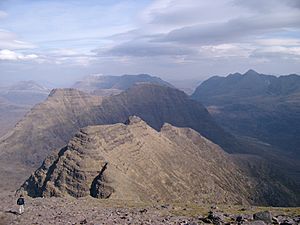
From the top of Sgùrr Mhòr, you can keep going along the ridge. It now turns towards the east. This part of the ridge becomes much rockier. Here, you will find a series of rocky points. They are known as the "Horns of Alligin" (Scottish Gaelic: Na Rathanan).
- In summer, the Horns offer good scrambling. This is a mix of walking and easy climbing. You need to be comfortable with heights for this part.
- In winter, the Horns are much more challenging. They can be very serious and require special skills.
Other Ways Down
If you want to avoid the Horns, there is another way down. You can leave the main ridge at the bealach (a mountain pass) between the two summits. From there, you can follow grassy slopes. These lead you westwards down into a nearby glen. This route is also difficult in winter conditions.
 | Madam C. J. Walker |
 | Janet Emerson Bashen |
 | Annie Turnbo Malone |
 | Maggie L. Walker |


