Garynahine facts for kids
Quick facts for kids Garynahine
|
|
|---|---|
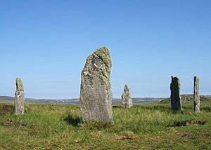
 The Callanish IV stone circle, just south of the settlement |
|
| Language | Scottish Gaelic English |
| OS grid reference | NB236317 |
| Civil parish | |
| Council area | |
| Lieutenancy area | |
| Country | Scotland |
| Sovereign state | United Kingdom |
| Post town | ISLE OF LEWIS |
| Postcode district | HS2 |
| Dialling code | 01851 |
| Police | Northern |
| Fire | Highlands and Islands |
| Ambulance | Scottish |
| EU Parliament | Scotland |
| UK Parliament |
|
| Scottish Parliament |
|
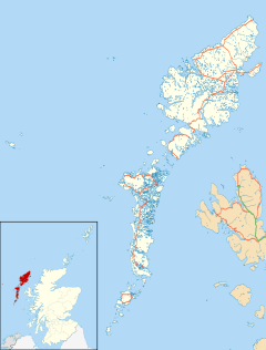
Garynahine (Scottish Gaelic: Gearraidh na h-aibhne) is a small village in the Outer Hebrides of Scotland. It's located on the Isle of Lewis, which is a large island off the west coast of Scotland. The village sits at an important crossroads where main roads meet, connecting places like Stornoway and Uig. This makes Garynahine a central spot in the area.
Contents
Exploring Garynahine's History
Garynahine is surrounded by interesting historical places. These sites tell us about the people who lived here long ago. They also show how the area has changed over time.
The Garynahine Estate
The land around Garynahine is known as the Garynahine Estate. A very rich man named Sir James Matheson owned it from 1844 to 1917. Later, another important person, Lord Leverhulme, bought it. Today, the estate is used for outdoor activities like hunting, shooting, and fishing.
On the estate, you can find Garynahine Lodge. This old building was once a hotel in the 1800s. It might even have parts of an even older inn that was there in the 1700s! Since 1925, it has been used as a lodge for people who come to hunt.
Ancient Stone Circles and Monuments
Just south of Garynahine, there are three amazing ancient sites. These are called Cul a'Chleit, Airidh nam Bidearan, and Sron a'Chail. They are protected historical places.
Sron a'Chail: A Stone Circle Mystery
Sron a'Chail is a circle of standing stones. It also has what looks like an old burial mound in the middle. These stones were put there a very long time ago, around the late Neolithic or early Bronze Age. That's thousands of years ago! There are five upright stones and one that has fallen over. This site is also known as one of the famous Callanish stones, specifically Callanish IV. Near here, people also found an ancient quarry where quartz rock was dug out.
Other Ancient Stones
Airidh nam Bidearan has three upright stone slabs. There might be other stones nearby too. Cul a'Chleit has two standing stones on a rocky hill. Experts think these stones might be what's left of a much bigger stone circle. Most of it was probably taken apart when small shelters called shielings were built nearby.
Discoveries from the Past
In 2002, a local person named Mr. Donald Angus Mackay found something interesting while cutting peat. He found some flat stone slabs. At first, people thought it might be a cist burial, which is a type of stone coffin.
The Wicker Basket Discovery
However, when archaeologists from Glasgow University looked closer, they found something different. It wasn't a burial. Instead, it was a pit with what they believe was a hazel wicker structure or basket. Imagine finding an ancient basket! They also found plants like heather and Sphagnum moss inside or around it. Scientists used radiocarbon dating to find out how old it was. They learned that this wicker structure was made and placed there during the Late Bronze Age. This discovery helps us understand more about how people lived and what they used thousands of years ago.
Images for kids
 | John T. Biggers |
 | Thomas Blackshear |
 | Mark Bradford |
 | Beverly Buchanan |


