
Grimsay facts for kids
| Gaelic name | Griomasaigh |
|---|---|
| Norse name | Grímsey |
| Meaning of name | ON: Grim's Island |
| OS grid reference | NF855572 |
| Coordinates | 57°29′N 7°14′W / 57.49°N 7.24°W |
| Physical geography | |
| Island group | Uist and Barra |
| Area | 833 ha (3.22 sq mi) |
| Area rank | 58 |
| Highest elevation | 22 m (72 ft) |
| Administration | |
| Sovereign state | United Kingdom |
| Country | Scotland |
| Council area | Outer Hebrides |
| Demographics | |
| Population | 169 |
| Population density | 20/km2 (52/sq mi) |
| Largest settlement | Bàgh Mòr and Ceallan |
Grimsay (which is Griomasaigh in Scottish Gaelic) is a small tidal island located in the Outer Hebrides of Scotland. A tidal island means it's connected to the mainland or another island by a path that appears only when the tide is low. Grimsay is a fascinating place with a rich history and a strong connection to the sea.
Contents
Exploring Grimsay's Geography
Grimsay is the biggest of several small, low-lying islands that act like stepping stones. These islands help form the Oitir Mhòr, also known as the North Ford causeway. A causeway is a raised road built across water or wet ground. This causeway is a 5-mile (8 km) single-track road. It connects North Uist and Benbecula by passing through the western part of Grimsay.
The North Ford Causeway
The North Ford causeway opened in 1960. Before this road was built, people had to use a ferry to travel between Carinish (on North Uist) and Gramsdale (on Benbecula). This ferry could only run when the tide was high enough. There was also a ford, which is a shallow place to cross water. People could only cross this ford when the water was very low, and usually needed a guide to help them. For many hours each day, the North Ford was too wet to cross by foot and not wet enough for the ferry. The causeway made travel much easier and safer.
Nearby Islands
To the east of Grimsay, you can find several smaller islands. One of these is Ronay, which used to have people living on it until 1931.
Life on Grimsay: People and Industry
In 2011, the island of Grimsay had a population of 169 people. This was a decrease from 2001, when 201 people lived there. The main villages on Grimsay are Baymore (Bàgh Mòr) and Kallin (Ceallan). These settlements are located at the eastern end of the island.
Kallin Harbour and Fishing
Kallin has a busy harbour. This harbour is very important for the island's main industry: fishing for shellfish. Fishermen from Grimsay catch many types of seafood, including lobsters, prawns, and scallops.
The Boatshed: Traditional Skills
Also in Kallin, you'll find a special place called The Boatshed. This facility repairs boats and helps keep traditional boat-building skills alive. It employs a full-time boat builder and also trains new people. For many years, three generations of the Stewart family built as many as 1,000 boats from three sheds on Grimsay. This shows how important boat building has been to the island's history.
Island Roads
A single-track road goes all the way around Grimsay. This road connects most of the island's small croft and fishing settlements. A croft is a small farm, often with a house, found in Scotland.
Grimsay's Ancient History
Grimsay has some interesting historical sites. On the northeast coast of the island, at a place called Bagh nam Feadag, there is a great example of an Iron-Age wheelhouse.
What is a Wheelhouse?
A wheelhouse is a type of ancient building from the Iron Age, which was a period in history when people started using iron tools. These buildings are called "wheelhouses" because their inside walls have stone piers or spokes that look like the spokes of a wheel. The wheelhouse on Grimsay is considered one of the best examples of this type of building in the North Uist area.
Images for kids
-
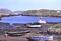
Bagh Mòr on Grimsay, with Ronay in distance
-
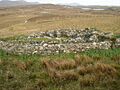
A wheelhouse on Grimsay


