
The Storr facts for kids
Quick facts for kids The Storr |
|
|---|---|
| An Stòr | |
 |
|
| Highest point | |
| Elevation | 719 m (2,359 ft) |
| Prominence | c. 674 metres (2,211 ft) (Ranked 73rd in British Isles) |
| Parent peak | Sgurr Alasdair |
| Listing | Graham, Marilyn |
| Geography | |
| Location | Trotternish, Skye, Scotland |
| OS grid | NG495540 |
| Topo map | Ordnance Survey Landranger 23 |
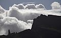
The Storr (Scottish Gaelic: An Stòr) is a famous rocky hill on the Trotternish peninsula of the Isle of Skye in Scotland. This amazing hill has a very steep, rocky side that faces east towards the Sound of Raasay. On the other side, facing west, you'll find gentler, grassy slopes.
Contents
Understanding the Storr's Geology
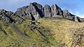
The Storr is a fantastic example of the Trotternish landslip. This is the longest landslip feature in all of Great Britain. A landslip happens when a large amount of rock or soil slides down a slope. The Storr is also where a special mineral called gyrolite was first found.
The area right in front of the Storr's cliffs is called the Sanctuary. Here, you can see many strangely shaped rock towers. These towers are what's left behind from ancient landslips that happened long ago.
How to Climb The Storr
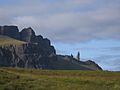
Many visitors enjoy walking on a well-made path that starts near Loch Leathan. This path goes through an area where trees were cut down, which used to be a forest. Most people who visit for the day just explore the Sanctuary. They love looking at the tall rock towers and the Storr's eastern cliffs.
If you want to reach the very top, it's quite easy for walkers. You can walk along the base of the cliffs, heading north from the Sanctuary. After crossing a fence and climbing a short, rocky part, the best path for walkers goes northwest. It leads to Coire Scamadal, which is about 1 kilometer north of the summit. From there, the path turns back and heads south, climbing towards the top.
There are some other paths that look like shortcuts through the cliffs. But these can be very steep and might not be safe or save you time. Another way to the top involves a bit of climbing over rocks. This route follows the edge of the cliffs that face southeast.
You can also start a climb to the summit about 500 meters southwest of the car park. This path goes northwest to Bealach Beag, which is about 1 kilometer southwest of the summit. It follows a stream that cuts through the cliffs. Be careful on a steep part of this path, as it can be slippery.
Sometimes, people climb the Storr as part of a much longer adventure. They hike along the entire length of the Trotternish landslip.
The Storr in Arts and Media
The Storr has inspired many artists and photographers.
- From August to September 2005, a huge environmental artwork was created near the Old Man of Storr and the Storr cliffs. This project was put on by NVA, a Scottish arts group. It included music, live performances by a Gaelic singer, and recordings of a famous Gaelic poet's work.
- In October 2009, a photo of the rock towers, looking towards Raasay and South Rona, won a big photography award called "Take a view: Landscape photo of the year."
- In January 2012, parts of the science-fiction movie Prometheus were filmed at the Old Man of Storr on the Isle of Skye.
- A British composer named Matthew Taylor wrote an orchestral piece called Storr. He was inspired by the amazing rock formations when he visited the area.
Images for kids
-
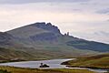
Old Man of Storr and The Storr
-
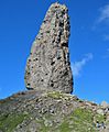
Bodach an Stoir (The Old Man of Storr)
-
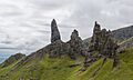
The Old Man of Storr, Skye
-
Old Man of Storr 2008, Skye
-
Profile of the Old Man, viewed from the north
-
Old Man of Storr from hiking trail

_-_geograph.org.uk_-_747492.jpg)


