South Rona facts for kids

| Gaelic name | Rònaigh |
|---|---|
| Norse name | Hraun eyer |
| Meaning of name | Norse for "rough islands" |
| OS grid reference | NG619563 |
| Coordinates | 57°32′24″N 5°58′41″W / 57.54°N 5.978°W |
| Physical geography | |
| Island group | Skye |
| Area | 930 hectares (3.6 sq mi) |
| Area rank | 52 |
| Highest elevation | Meall na h-Acarsaid 125 metres (410 ft) |
| Administration | |
| Sovereign state | United Kingdom |
| Country | Scotland |
| Council area | Highland |
| Demographics | |
| Population | 3 |
| Population density | 0.3 people/km2 |
| Largest settlement | An Acarsaid Mhòr |
 |
|
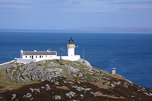
| South Rona Lighthouse | |
| Location | South Rona Isle Skye Inner Hebrides Scotland United Kingdom |
|---|---|
| Coordinates | 57°34′41″N 5°57′33″W / 57.578135°N 5.959046°W |
| Year first constructed | 1857 |
| Automated | 1975 |
| Construction | masonry tower |
| Tower shape | cylindrical tower with balcony and lantern |
| Markings / pattern | white tower, black lantern, ochre trim |
| Height | 13 metres (43 ft) |
| Focal height | 69 metres (226 ft) |
| Range | 19 nautical miles (35 km; 22 mi) |
| Characteristic | Fl W 12s. |
| Admiralty number | A3904 |
| NGA number | 3660 |
| ARLHS number | SCO-185 |
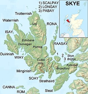
Rona (Scottish Gaelic: Rònaigh) is a small island in Scotland, part of the Inner Hebrides. It is sometimes called South Rona to tell it apart from another island called North Rona. The island is located between the Sound of Raasay and the Inner Sound.
Rona lies just north of the island of Raasay and east of the Trotternish area on the Isle of Skye. It covers an area of about 930 hectares (3.6 square miles). Only three people live on Rona today.

Contents
Exploring Rona's Land and Rocks
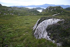
Rona is like a northern extension of the island of Raasay. Its land is made up of very old rocks called Lewisian gneiss. These rocks are some of the oldest in Western Europe. The island's landscape was shaped by glaciers long ago.
In the early 1700s, a writer named Martin Martin described Rona. He said it was a very rocky place with only a few small areas suitable for digging. Most of the island was covered in long heather and other plants. He noted it was good for grazing animals.
Natural Harbors and Bays
On the west side of Rona, there is a safe and beautiful natural harbor called An Acarsaid Mhòr. A small island named An t-Eilean Garbh protects this harbor. Another writer, Malcolm Slesser, called it a "delightful little fjord" and a great place for small boats. He mentioned the pink cliffs and lush woodlands there.
Other small islands around Rona include Eilean Seamraig and Garbh Eilean. Garbh Eilean connects to Rona when the tide is low. Tiny Fraoich Eilean is in the middle of the narrow water channel called An Caol Ronaigh.
The east coast of Rona is mostly straight. Besides An Acarsaid Mhòr, the main bays are An Dubh-Chamus (meaning "black bay") and An Acaarsaid Thioram (meaning "dry harbor"). There are also smaller bays in the northwest, like Port an Fhearainn ("port of the land").
Island Peaks
The highest point on Rona is Meall na h-Acarseid, which is 125 meters (410 feet) tall. Further north, Sgàth a' Bhannaich and Beinn na h-Iolaire (meaning "hill of the eagle") are both over 100 meters (328 feet) high.
Rona's Past: A Journey Through Time
Ancient Times and Viking Names
The name "Rona" likely comes from the Old Norse words Hraun-eyer, which mean "rough islands." This suggests that Vikings might have settled here long ago. The Gaelic name Rònaigh has a similar meaning.
Early History and Pirate Hideouts
At the southern end of the island, you can find the ruins of a small chapel from the 1300s. This building was probably a monk's cell. It has a wall around it, and inside, there's the island's only gravestone.
In the 1500s, Rona became a hiding spot for pirates. They used An Acarsaid Mhòr as their base, which was then known as Port nan Robairean – "port of the robbers." These pirates might have mostly attacked foreign ships, as local clan leaders seemed to tolerate them. One pirate leader, Calum Garbh MacLeod, used Rona as a base for his raids in 1518.
In 1549, Dean Monro wrote about Rona. He described it as an island full of wood and heather, with a harbor good for "fostering of thieves." He noted that the island belonged to the MacLeod clan by force and to the bishop by heritage.
Modern Era: Changes and Challenges
The MacLeod clan owned Rona until the mid-1800s. In 1763, the Laird of Raasay kept cattle on the island. Later, in 1787, he looked into starting commercial fishing there. He believed Rona was a great spot for fishing because of the many fish banks around it and its excellent harbors. However, his support for the Jacobite cause meant his plans didn't happen.
In 1843, Rona and Raasay were sold to George Rainy. He began to remove the local people from Raasay to make space for sheep. This event was part of what is known as the Highland Clearances.
| Year | 1841 | 1851 | 1861 | 1881 | 1891 | 1922 | 1931 | 1971 | 1981 | 1991 | 2001 | 2011 |
|---|---|---|---|---|---|---|---|---|---|---|---|---|
| Population | 165 | 115 | 147 | 176 | 181 | 14 families | 16 | 3 | 3 | 0 | 2 | 3 |
After the first clearances, Rona's population grew to over 180 people. Many of these residents were families who had been moved from more fertile lands on Raasay. They lived in settlements like Doire na Guaileadh and An Acarsaid Mhór.
In May 1921, a group of farmers from Rona went to Raasay. They tried to reclaim the land their families had lived on for generations. These people, known as the "Raasay Raiders," were arrested and jailed. However, many people supported them. They were eventually freed and allowed to stay on Raasay.
This event led to the British Government buying Rona and Raasay from their private owner in 1922. After this, Rona's population quickly dropped. Most of the island's residents followed the Raiders to settle on Raasay. By 1943, the last farming family left Rona. The island became uninhabited, except for the lighthouse keepers. The lighthouse became automated in 1975, meaning it no longer needed keepers.
On the east side of Rona, there is a cave that was used for Sunday church services. People used it until a church was built in 1912. The cave, called "Uamha an Fhuaimhar" (meaning "cave of the giant"), was still used sometimes until 1970.
In 1992, a Danish owner bought Rona from the government. He fixed up Rona Lodge at An Acarsaid Mhòr and built a new boat landing. Today, Rona has two permanent residents: the island manager and his wife. They live at Rona Lodge, where visitors can find B&B and bunkhouse places to stay. They also manage self-catering cottages at An Acarsaid Thioram. Visitors usually travel to the island by private boat from Portree. A small part of the northern end of the island is still owned by the Ministry of Defence.
Rona's Stamps
Since 2003, Rona has issued its own local stamps. Visitors to the island can use these stamps to mail letters. The mail is then carried to the nearest official post box on the mainland.
Wildlife on Rona
In the 1960s, researchers Fraser Darling and Boyd noted that Rona had a group of wild goats. They also observed that there were no mice or voles on the island. The goats are no longer there.
However, red deer were brought to the island in 1993. A group of Highland cattle from North Uist arrived in 1996. Over 300 different types of plants have been found on Rona. Because there are no sheep grazing, the island's native woodlands are growing back.
 | Leon Lynch |
 | Milton P. Webster |
 | Ferdinand Smith |

