Rubha an Dùnain facts for kids
Quick facts for kids Rubha an Dùnain |
|
|---|---|

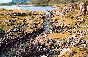
The Viking Canal leaving Loch na h-Airde
|
|
| Location | Skye, Scotland |
| OS grid | NG391161 |
| Coordinates | 57°09′40″N 6°18′58″W / 57.161°N 6.316°W |
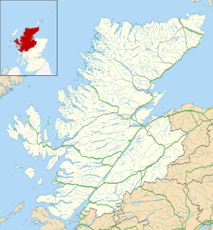
Rubha an Dùnain (also called Rubh' an Dùnain) is a quiet, empty piece of land sticking out into the sea. It's located on the Isle of Skye in Scotland, south of the Cuillin hills. This special place has very old archaeological sites. In 2017, these sites were officially named a Historic Monument by Historic Environment Scotland. This means they are super important to the country's history.
This headland rises more than 30 meters (about 98 feet) above the sea. Near the peninsula, to the east, is a freshwater lake called Loch na h-Airde. To the north, you'll find a bay named Camas a' Mhùrain, which means "bay of the marram grass."
Rubha an Dùnain has archaeological sites from the Mesolithic period and later. The name comes from Gaelic. Rubha an Dùn clearly means "headland of the fort." The last part, Dùnain, might mean "bird's hill" or "John's fort."
Contents
Ancient Discoveries at Rubha an Dùnain
This area holds many clues about people who lived here long ago.
Homes from the Stone Age
To the north, you can find traces of very old settlements. One is a small rock shelter from the Mesolithic period (Middle Stone Age). There's also a chambered cairn from about 2,000 or 3,000 BC. This is a type of ancient burial mound. Another discovery is a passage grave, which is a long stone corridor leading to a burial chamber.
Iron Age Forts
South of the loch, there are remains of a dun. A dun is an ancient fort, usually built on a hill. This one likely dates back to the Iron Age.
Loch na h-Airde and the Viking Canal
Loch na h-Airde is a key part of Rubha an Dùnain's history.
The Mysterious Canal
People have known for a while about an artificial "canal" here. It was thought to be built by Vikings and runs from the loch to the sea. In 2000, an archaeologist found a piece of wood from a Norse-style boat in the loch. Tests showed it was from around 1100 AD.
Uncovering the Harbor
In 2009, a study found stone docks and a system to keep the water level steady in the loch. This "canal" allowed boats, like the old Scottish birlinns, to sail out at high tide. Historic Environment Scotland calls this a "rare medieval harbour complex." It includes docks, places to store boats (noosts), the canal, and quays. They believe boat pieces might still be hidden in the loch's bed.
A Unique Historical Site
Historic Environment Scotland says there's no other place quite like this in Scotland. It's special because it shows how the area developed over a long time. Experts now think the loch was a very important place for boats and sea travel for many centuries. This includes the time of the Vikings and later periods when Scottish clans ruled.
Looking for More Clues
In 2011, the RCAHMS (now part of Historic Environment Scotland) used air surveys to find more ancient items. Marine archaeologist Dr. Colin Martin said this site could teach us a lot about how boats were built and used in Scotland long ago. He added, "There is no other site quite like this in Scotland." You can find his report, "A Highway into History," online.
Life After the Vikings
After the Viking era, Rubha an Dùnain became the traditional home of the MacAskill clan. They were part of Clan McLeod and worked as coast-watchers and bodyguards.
Farming Life and Changes
The peninsula still has the ruins of an old farming community. This includes an 18th-century house belonging to a Tacksman, who managed the farm. At its busiest, in the early 1800s, the Rubha an Dùnain farm was huge. It supported 70 men and many families. However, the area was later emptied during the Highland Clearances. Many clan leaders moved to places like the US and New Zealand. After 1861, no one was recorded living there in the official census.
 | Tommie Smith |
 | Simone Manuel |
 | Shani Davis |
 | Simone Biles |
 | Alice Coachman |


