
Cuillin facts for kids
Quick facts for kids Cuillin Hills National Scenic Area |
|
|---|---|

|
|

Cuillin Hills National Scenic Area
Location in Highland
|
|
| Location | Isle of Skye, Highland, Scotland |
| Area | 227 km2 (88 sq mi) |
| Established | 1981 |
| Governing body | NatureScot |
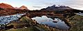
The Cuillin (pronounced Coo-lin) is a group of rocky mountains on the Isle of Skye in Scotland. These mountains are split into two main parts: the Black Cuillin and the Red Cuillin. The Red Cuillin are also called the Red Hills by local people. They are found to the east of a valley called Glen Sligachan.
The Black Cuillin mountains are mostly made of a dark, rough rock called gabbro. This rock is great for climbers because it gives them a good grip. They also have some basalt rock, which can be very slippery when wet. These mountains look dark, but in the sunlight, they can appear grey or brown. The main ridge is a narrow line of peaks with steep cliffs. It is about 14 kilometers (9 miles) long. It curves around a beautiful lake called Loch Coruisk, which is in the middle of the mountains. The highest point in the Cuillin, and on Skye, is Sgùrr Alasdair in the Black Cuillin. It stands at 992 meters (3,255 feet) tall.
The Red Cuillin are mostly made of granite, which is lighter in color and can look reddish. These hills are more rounded and have more plants growing on them, even near the top. They are not as rocky as the Black Cuillin and are generally lower. The highest point in the Red Cuillin is Glamaig, which is 775 meters (2,543 feet) high.
The Cuillin mountains are so beautiful that they have been named a National Scenic Area. This is one of 40 such special places in Scotland. Experts say that the mountains rise dramatically from the sea. This creates amazing, enclosed sea lochs. Many famous views of Scotland are found here.
Contents
What's in a Name?

There are a few ideas about where the name Cuillin comes from. Some people think it comes from an old Viking word, kjölen, which means "ridges." This word might also refer to the "keel" of a boat. This would mean the mountains look like an upside-down Viking longship.
Another idea comes from Gaelic stories. It suggests a link to Celtic mythology. The hills might be where the hero Cuchullin learned to shoot arrows from a female warrior named Scáthach. Some also think the name might mean "worthless." This is because the hills have little plant life and were not good for farming.
Nature and Wildlife
The Cuillin mountains have a very interesting and complex geology. You can clearly see the difference between the two types of mountains. These mountains were formed from the remains of magma chambers. These chambers once fed powerful volcanic eruptions. In the Black Cuillin, the rocks cooled to form gabbro. This is the rough, dark rock that makes up most of the range. Cracks in the rock allowed hot magma to push through later. This created dykes of basalt rock, which are common across Skye.
The Red Cuillin also formed from volcanoes. They were made from a later push of lighter, granitic rock. Wind and water wore down this granite more evenly. This is why the Red Hills have smoother shapes.
The Cuillin are a great example of how glaciers shaped the land. They were studied early on by James David Forbes in 1846. He worked with Louis Agassiz on a trip to Scotland in 1840. Later, in 1904, Alfred Harker wrote the first detailed scientific study of an extinct volcano here.
The Cuillin has many different natural areas, changing as you go higher. At the bottom, there are conifer forests and coastal woodlands. There are also areas of heather moorland and rough grasslands. The lower slopes have different types of boggy ground. Higher up, above 400 meters, there is grassland on drier slopes. The highest parts are mostly bare rock and loose stones.
The entire area is a Special Protection Area because it is very important for golden eagles. This place is special for these birds in Europe. It has one of the highest numbers of golden eagles in Britain. They also have many successful young birds here.
Mountain History

The Cuillin mountains have not been used much for farming. This is different from most of the Scottish Highlands. In other areas, hills were used for seasonal grazing for cattle and sheep. Even though people didn't live in the mountains themselves, there is proof of old settlements in the valleys around them. You can find ancient hut circles in Glenbrittle. There is also a stone circle in Glen Sligachan.
A nearby, uninhabited area called Rubha an Dùnain has many old sites. These date back to the Neolithic period (New Stone Age). There is an ancient burial mound from 2000-3000 BC. There is also an Iron Age fort and another old settlement from the Bronze Age. A lake on this land is connected to the sea by an artificial "Viking" canal. This canal might be from when the Norse people lived here.
The Norse ruled the Hebrides islands from the 800s until 1266. After them, the most powerful clans on Skye were Clan MacLeod and Clan Macdonald of Sleat. The Mackinnons also became an important clan. The MacDonalds and MacLeods were big rivals. They fought two major battles in the Cuillin:
- In 1395, MacDonald warriors landed at Loch Eynort. They marched north along Glen Sligachan to attack MacLeod land. MacLeod fighters met them at Harta Corrie, below Sgùrr nan Gillean. The MacDonalds won this battle. It is said they fought until no MacLeod was left. The bodies were piled around a large rock. This rock, topped by a Rowan tree, is still called the 'Bloody Stone'.
- The Battle of Coire Na Creiche was the last Scottish clan battle on Skye. It happened in 1601 on the slopes below Bruach na Frìthe. The MacDonalds of Sleat defeated the MacLeods after a long disagreement.
James Boswell and Samuel Johnson visited Skye in 1773. They saw snow falling on the mountain tops in September. Boswell said the Cuillin were "a huge range of mountains, topped with rocks like sharp points in many strange shapes."
Most Cuillin peaks were not climbed until mountaineering became a hobby in the Victorian era. About half of the peaks didn't even have names before this time. Many peaks are now named after early climbers. These include John MacKenzie (Sgùrr MhicChoinnich), Alexander Nicolson (Sgùrr Alasdair), and Norman Collie (Sgùrr Thormaid).
Who Owns the Cuillin?
The Cuillin is now split into two main areas by Glen Sligachan. The mountains on the west side (the Black Cuillin) still belong to the MacLeod Clan. This is despite their long history of fights with the MacDonald Clan. The MacLeods have owned this land since at least 1611. Today, the main range is still owned by the MacLeod family.
The land on the eastern side of Glen Sligachan includes the Red Cuillin and Bla Bheinn. This area is owned by the John Muir Trust. This charity works to protect wild places. The famous musician Ian Anderson (from the band Jethro Tull) used to own this land. He sold it to the trust in 1994.
Climbing and Walking

The tops of the Cuillin mountains are bare rock. They have jagged shapes, steep cliffs, and deep valleys called corries and gullies. Twelve peaks in the Black Cuillin are called Munros. Munros are Scottish mountains over 3,000 feet (914 meters) high. One of them, Blaven, is a bit separate from the main ridge.
Most of the individual peaks can be reached by their easiest routes. These often involve scrambling. Scrambling is like climbing, but you use your hands more than regular walking. Only the Inaccessible Pinnacle needs proper rock climbing skills. Finding your way on the ridge can be hard. This is because the ground is very rough, and compasses can be unreliable due to magnetic rocks. Most people start their climbs from Glenbrittle or Sligachan. Loch Coruisk is harder to reach. You can only get there by boat or a long walk.

A big challenge for climbers is to complete a full trip along the main Black Cuillin ridge. It's only about 11 kilometers (7 miles) long. But it usually takes 15–20 hours to finish. This is because the ground is difficult and it's hard to find the best path. The first time someone completed the whole trip in under 24 hours was in 1911. The fastest time for the full trip is 2 hours, 59 minutes, and 22 seconds. This record was set by Finlay Wild in 2013. One problem for those doing the full trip is that there is no natural water on the ridge. You can only find water from melting snow or small streams just off the main ridge.
Some climbers think that doing the full Cuillin Ridge trip in winter is the ultimate challenge in the UK. But real winter conditions are rare on Skye. This is because the island is close to the warm Gulf Stream. Also, winter days are very short, making a 24-hour trip difficult. The first recorded winter trip, over two days, was in 1965.
A longer challenge is called the "Greater Traverse." This includes all the Skye Munros. It also adds Clach Glas and Blaven. Two groups completed this trip independently in 1939.
Cuillin Mountain List
Here is a list of the main peaks in the Cuillin. It includes Munros, Corbetts, and Grahams. These are different types of hills based on their height.
| Summit | Range | Classification | Height (m) | Relative height (m) | Easiest Route Grade | Easiest Route |
|---|---|---|---|---|---|---|
| Sgùrr nan Gillean | Black Cuillin | Munro | 964 | c. 204 | Grade 3 scramble | South-east ridge |
| Am Basteir | Black Cuillin | Munro | 934 | c. 55 | Grade 2 scramble | East ridge (avoiding "Broken Step") |
| Bruach na Frìthe | Black Cuillin | Munro | 958 | c. 125 | Walk | Via Fionn Choire |
| Sgùrr a' Mhadaidh | Black Cuillin | Munro | 918 | c. 71 | Grade 2/3 scramble | North-west or south ridges |
| Sgùrr a' Ghreadaidh | Black Cuillin | Munro | 973 | c. 123 | Grade 3 scramble | North ridge |
| Sgùrr na Banachdaich | Black Cuillin | Munro | 965 | c. 114 | Walk | Via Coire nan Eich |
| Inaccessible Pinnacle (Sgùrr Dearg) | Black Cuillin | Munro | 986 | 182 | Moderate rock climb | East ridge of Inaccessible Pinnacle |
| Sgùrr MhicChoinnich | Black Cuillin | Munro | 948 | c. 56 | Grade 2 scramble | North ridge |
| Sgùrr Alasdair | Black Cuillin | Munro | 992 | 992 | Grade 2 scramble | North-east ridge from Great Stone Chute |
| Sgùrr Dubh Mòr | Black Cuillin | Munro | 944 | c. 89 | Grade 2 scramble | From Coir' a' Ghrunnda |
| Sgùrr nan Eag | Black Cuillin | Munro | 924 | c. 127 | Grade 1/2 scramble | From Coir' a' Ghrunnda |
| Blà Bheinn | Outlier (Blaven group) | Munro | 928 | 301 | Walk | Via Coire Uaigneis |
| Garbh-bheinn | Outlier (Blaven group) | Corbett | 808 | 172 | Walk | From head of Loch Ainort |
| Glamaig | Red Cuillin | Corbett | 775 | c. 480 | Walk | From Sligachan |
| Marsco | Red Cuillin | Graham | 736 | 413 | Walk | From Sligachan |
| Beinn Dearg Mhòr | Red Cuillin | Graham | 731 | 152 | Walk | From Sligachan |
| Belig | Red Cuillin | Graham | 702 | 246 | Walk | From head of Loch Ainort |
Gallery

-
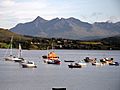
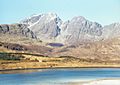
The North Cuillin viewed from Portree.
-
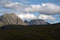
Marsco (left), Clach Glas and Blà Bheinn from Allt Dearg Mòr path.
-
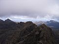
On the Cuillin Ridge
-
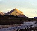
Marsco in the Red Hills
-
Bla Bheinn from Loch Slapin
-
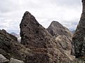
The vertical west face of the Bastier Tooth (a top next to Am Basteir) in the Cuillin, with Sgùrr nan Gillean in the background
-
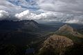
Glen Sligachan enclosed by the Black Cuillin and Marsco from South Blà Bheinn.
-
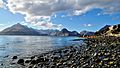
The Black Cuillin mountains viewed from Elgol.
-
The Cuillin mountains viewed from Sligachan.


See also
 In Spanish: Cuillin para niños
