Blà Bheinn facts for kids
Quick facts for kids Blà Bheinn |
|
|---|---|
| Blaven | |
 |
|
| Highest point | |
| Elevation | 929 m (3,048 ft) |
| Prominence | 862 m (2,828 ft) Ranked 19th in British Isles |
| Parent peak | Sgurr Alasdair |
| Listing | Munro, Marilyn |
| Naming | |
| English translation | Blue mountain |
| Language of name | Norse/Gaelic |
| Geography | |
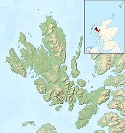
| Location | Skye, Scotland |
| Parent range | Cuillin (outlier) |
| OS grid | NG530217 |
| Topo map | OS Landranger 32 |
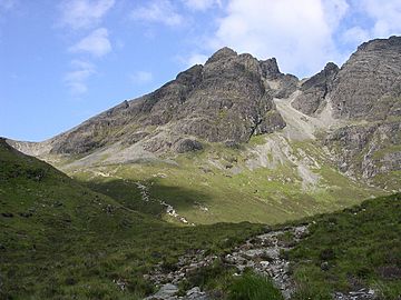
Blà Bheinn, also known as Blaven, is a famous mountain on the Isle of Skye in Scotland. It is often seen as a separate peak from the main Black Cuillin mountain range. This mountain is special because it is mostly made of a rock called gabbro. Gabbro is excellent for climbers and scramblers because it gives a very good grip. The name Blà Bheinn probably means "blue mountain." It comes from a mix of Norse and Gaelic words.
Contents
Blà Bheinn: Scotland's Blue Mountain
Blà Bheinn is a tall and impressive mountain. It stands at 929 meters (about 3,048 feet) high. This makes it a Munro, which is a Scottish mountain over 3,000 feet. It is also a Marilyn, meaning it has a certain height above the surrounding land.
What Makes Blà Bheinn Special?
One unique thing about Blà Bheinn is the type of rock it's made of. This rock is called gabbro. Gabbro is a dark, rough rock. It's very popular with people who enjoy climbing and scrambling. This is because the rock's rough surface helps climbers keep a strong grip.
The name Blà Bheinn is quite old. It is thought to mean "blue mountain." This name comes from a mix of Norse and Gaelic words. The word for "blue" in Old Norse could also mean blue-black or even black. This might refer to the mountain's dark, rocky appearance.
Climbing Blà Bheinn
Climbing Blà Bheinn is a popular adventure for many hikers. There are a few ways to reach the top.
The Normal Path Up
The most common way to climb Blà Bheinn is from the east side. You can find a path near the B8083 road. This road runs along the shores of Loch Slapin. The path starts about 4 kilometers (2.5 miles) past the village of Torrin.
The path follows a small stream called the Allt na Dunachie. It leads into a bowl-shaped valley known as Coire Uaigneich. From there, you follow a short, steep path along a ridge. This ridge takes you right to the summit. You will need to do a little bit of scrambling to reach the very highest point. Scrambling means using your hands as well as your feet to climb over rocks.
Other Ways to Climb
There are other ways to climb Blà Bheinn for more experienced climbers. Some people choose to follow the south ridge. Others come from the north. They might cross the Clach Glas ridge first. This ridge connects to the Red Cuillin peaks, which are another part of the Cuillin range.
Amazing Views from the Top
When you reach the summit of Blà Bheinn, you get an incredible view. The most striking sight is the Black Cuillin mountain range. These are jagged, dark mountains that look very dramatic. You can see them clearly from Blà Bheinn's peak.
Protecting Blà Bheinn
Blà Bheinn is part of the Strathaird Estate. This area has been looked after by the John Muir Trust since 1994. The John Muir Trust is a charity that works to protect and care for wild places in the UK. They help make sure that special places like Blà Bheinn stay beautiful for everyone to enjoy.
 | Jackie Robinson |
 | Jack Johnson |
 | Althea Gibson |
 | Arthur Ashe |
 | Muhammad Ali |


