
Scalpay, Inner Hebrides facts for kids
| Gaelic name | Sgalpaigh (an t-Sratha) |
|---|---|
| Norse name | Skalprøy |
| Meaning of name | ship island |
| OS grid reference | NG605315 |
| Coordinates | 57°19′N 5°59′W / 57.31°N 5.98°W |
| Physical geography | |
| Island group | Skye |
| Area | 2,483 ha (9+5⁄8 sq mi) |
| Area rank | 32 |
| Highest elevation | Mullach na Càrn, 396 m (1,299 ft) |
| Administration | |
| Sovereign state | United Kingdom |
| Country | Scotland |
| Council area | Highland |
| Demographics | |
| Population | 4 |
| Population density | 0.16/km2 (0.41/sq mi) |
Scalpay (pronounced SKAL-pay) is a small island in Scotland. It is part of the Inner Hebrides group of islands. Only a few people live on Scalpay, with a population of just 4 residents. It is located near the larger island of Skye.
Contents
What is Scalpay's Land Like?
Scalpay is mostly made of old rocks. These rocks are a type of sandstone and conglomerate. They formed a very long time ago. You can also find other types of rocks here. These include basalt and granite.
How Scalpay's Land Was Formed
The island's rocks show its long history. Some rocks are from the Lias Group. Others are from the late Jurassic period. These different rock layers tell us about Earth's past.
What Else Covers the Island?
Parts of Scalpay are covered by peat. This is a type of soil made from decayed plants. You can also find sand and other materials along the coast. These were left by the sea. Some areas have glacial till. This is rock and dirt left behind by ancient glaciers.
Where is Scalpay Located?
Scalpay is separated from the east coast of Skye by a narrow body of water. This water is called Loch na Cairidh. The highest point on Scalpay is Mullach na Càrn. This peak is about 396 meters (1,299 feet) tall. The island covers an area of almost 25 square kilometers (9.6 square miles).
Who Lives on Scalpay?
In 2001, ten people lived on Scalpay. By 2011, the population had changed. Only four people lived there then. This makes it a very quiet and peaceful place.
What is Scalpay Used For?
Scalpay is a privately owned island. It has a red deer farm. This means deer are raised there. It is also used for hunting. There are holiday cottages for visitors. Much of the island is covered in heather plants. Other parts have conifer trees planted in forests.
What Does the Name Scalpay Mean?
The name "Scalpay" comes from an old language. Experts believe it comes from the Norse language. One idea is that it means "ship island." This might be because its shape looks like a ship. Another idea is that it means "scallop island." This could be because of the shellfish found nearby.
How Old is Scalpay?
Scientists have found very old tools on Scalpay. These tools are made of stone. They show that people lived on the island a long, long time ago. These early people were from the Mesolithic period. This period was thousands of years ago.
Finding Ancient Tools
Between 1999 and 2004, a big project took place. People searched the coastlines for old sites. On Scalpay, they found nine places with stone tools. Three of these sites had tiny stone tools called microliths. These tiny tools confirm that people lived there during the Mesolithic period.
Scalpay's Past
In 1549, a man named Dean Monro described Scalpay. He said it was a good place for hunting deer. It had small woods and towns. He also said it had good fishing spots. At that time, the island belonged to the Clan Maclean.
Later Owners of Scalpay
Later, in the 1700s, a tenant of Sir Alexander Macdonald held the island. In the late 1800s, a rich businessman named Donald Currie owned Scalpay. He helped build the first roads on the island. He also planted many trees.
Images for kids
-
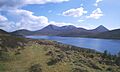
Looking south to Skye from Scalpay.

See also
 In Spanish: Scalpay para niños
