
Quiraing facts for kids
Quick facts for kids Quiraing (Meall na Suiramach) |
|
|---|---|
| A' Chuith-Raing (Scottish Gaelic) | |

Quiraing
|
|
| Highest point | |
| Elevation | 543 m (1,781 ft) |
| Naming | |
| English translation | Round Fold |
| Language of name | Old Norse |
| Geography | |
| Location | Trotternish, Skye, Scotland |
| OS grid | NG446695 |
| Topo map | Ordnance Survey Landranger 23 |
The Quiraing (Scottish Gaelic: A' Chuith-Raing) is a huge landslip on the eastern side of a mountain called Meall na Suiramach. This mountain is the most northern peak in the Trotternish area on the Isle of Skye, Scotland. The entire Trotternish Ridge has many steep slopes that were formed by a long series of giant landslides. The Quiraing is special because it is the only part of these landslides that is still moving today! Because of this, the road at its base, near Flodigarry, needs to be fixed every year.
Contents
What is the Quiraing?
The Quiraing is a dramatic landscape created by ancient landslips. It is a popular spot for hikers and photographers because of its unique rock formations and amazing views. The area is part of a larger geological feature called the Trotternish landslip, which is the longest landslip in Great Britain.
Amazing Rock Formations
Some parts of the Quiraing's unique landscape have been given special names because of their interesting shapes. These names help people imagine what the rocks look like.
The Needle
The Needle is a tall, jagged rock that stands about 120 feet (37 meters) high. It looks like a giant needle pointing towards the sky. This impressive rock is a leftover piece from the huge landslip that shaped the area.
The Table
Northwest of The Needle, you will find The Table. This is a flat, grassy area that has slipped down from the top of the mountain. From The Table, you can see amazing views of the Torridon Hills and the mountains of Wester Ross in the distance. It's a great spot to take a break and enjoy the scenery.
The Prison
Southwest of The Table is The Prison. This is a rocky peak shaped like a pyramid. If you look at it from the right angle, it can look just like an old castle tower from medieval times. Climbing this peak is a bit tricky, but it offers fantastic views.
Where Did the Name Come From?
The name Quiraing comes from an old language called Old Norse. The original name was Kví Rand, which means 'Round Fold'. Inside this 'fold' is The Table, the flat area hidden among the tall rock pillars. People say that this hidden 'fold' was used a long time ago to hide cattle from Viking raiders who used to visit the area.

Images for kids
-
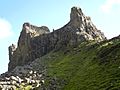
"The Prison" from the main pathway.
-
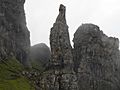
"The Needle" from "The Prison"


