
Firth of Clyde facts for kids
Quick facts for kids Firth of Clyde |
|
|---|---|

Map of the Firth of Clyde.
|
|
| Lua error in Module:Location_map at line 420: attempt to index field 'wikibase' (a nil value). | |
| Location | Scotland, United Kingdom |
| Basin countries | Scotland, United Kingdom |
| Surface elevation | Sea level |
| Islands | Isle of Arran, Isle of Bute, Isle of Cumbrae |


The Firth of Clyde is like the wide mouth of the River Clyde. You'll find it on the west coast of Scotland. It's super deep, reaching 164 meters (about 538 feet) at its deepest point! That makes it the deepest coastal water in the British Isles.
The firth is protected from the big waves of the Atlantic Ocean by the Kintyre peninsula. This peninsula wraps around the outer part of the firth in Argyll and Ayrshire. A large arm of the Firth of Clyde, called the Kilbrannan Sound, separates the Kintyre Peninsula from the Isle of Arran. Another important island inside the Firth of Clyde is the Isle of Bute. During World War II, Bute was very important for the navy because of its location.
The weather in the Firth is affected by the Gulf Stream. This warm ocean current starts far away in the Gulf of Mexico.
At its entrance, the firth is about 26 miles (42 km) wide. Further inside, it connects with Loch Long and the Gare Loch. This area includes a large place where ships can anchor, called the Tail of the Bank near Greenock. The "Bank" refers to a sandy area that separates the firth from the estuary of the River Clyde. Even where the sandbank makes it narrower, the Clyde is almost 2 miles (3 km) wide. The tide reaches all the way up to a weir near Glasgow Green.
People sometimes get confused about where the firth ends and the River Clyde begins. Some say Dumbarton is on the "Firth of Clyde." But people in Port Glasgow and Greenock often call the part of the firth near them "the river." In Scottish Gaelic, the inner part of the firth is called Linne Chluaidh. The area around the south of Arran, Kintyre, and Ayrshire is called An Linne Ghlas.
Contents
Exploring the Firth of Clyde
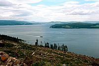
The Firth of Clyde has many islands and peninsulas. There are 12 ferry routes that connect these places to the mainland and to each other. People sometimes call the Firth the Clyde Waters. It's usually seen as part of the Irish Sea. Two companies, Caledonian MacBrayne and Western Ferries, run the ferry services. Many of these ferries are vital for people living in remote areas. Lots of sea lochs (long, narrow inlets of the sea) also join the Firth. The biggest one is Loch Fyne.

The Cowal Peninsula
The Cowal peninsula stretches into the Firth of Clyde. It forms a big part of the western shoreline of the upper firth. The main town on the Cowal peninsula is Dunoon.
Ferry Journeys
Taking a ferry across the Firth of Clyde can save a lot of travel time. It's much quicker than driving all the way around by road.
- The ferry between Dunoon and Gourock is for foot passengers only. It connects directly with train services to Glasgow. This service is run by Caledonian MacBrayne.
- Western Ferries operates a service between Hunters Quay and McInroy's Point. This ferry carries cars, trucks, and foot passengers.
Towns and Villages Along the Shore

Many towns and villages are located along the firth's shoreline. Here are some of the main ones:
- Ardrossan, Ayr
- Barassie, Brodick
- Campbeltown, Cardross, Carradale
- Dumbarton, Dunoon
- Fairlie
- Gourock, Greenock, Girvan
- Helensburgh, Hunter's Quay
- Innellan, Inverkip, Irvine
- Kilcreggan, Kilmun, Kirn
- Lamlash, Largs, Lochranza
- Millport
- Port Bannatyne, Portencross, Port Glasgow, Prestwick
- Rothesay
- Saltcoats, Seamill, Skelmorlie, Stevenston, Strone
- Toward, Troon
- Wemyss Bay, West Kilbride
Islands of the Clyde
The firth has many islands. The biggest ones have busy communities and regular ferry services to the mainland. They are:


Sea Lochs Connected to the Clyde

Several sea lochs branch off from the Firth of Clyde:
- Gare Loch
- Loch Long, and Loch Goil
- The Holy Loch at Sandbank, Argyll on the Cowal Peninsula
- Loch Striven
- Loch Riddon off the Kyles of Bute
- Loch Fyne, Loch Gilp and Loch Shira
- Loch Ranza
- Campbeltown Loch
- Loch Ryan
- East Loch Tarbert
- Loch Gair
History of the Firth
The Clyde has been an important sea route for a very long time. For example, the Battle of Largs in 1263 was a major event. It marked the end of Norse power in Britain. From the 1500s onwards, the Clyde became a busy pathway for trade. Many goods passed through, like herring, timber, wine, sugar, tobacco, and textiles. Later, it was used for iron, steel, coal, oil, chemicals, and even ships and trains.
In the mid-1800s, yachting became very popular on the Clyde. The area became famous worldwide for building yachts. Designers like William Fife III and Alfred Mylne were well-known. Even today, "Clyde-built" wooden yachts are known for their high quality and style.
During the Victorian era, tourism grew. People from Glasgow and nearby areas would travel "doon the watter" (down the water) on Clyde steamers. They would holiday in the pretty seaside towns and villages along the firth. Wealthier families even built large holiday homes. Towns like Gourock, Largs, Ayr, Dunoon, and Rothesay became popular resorts with hotels and attractions. Many golf courses, including championship ones, were built.
The shipyards in Greenock and Port Glasgow, especially Scott Lithgow, were very important for shipbuilding. The PS Comet was the first successful steamboat in Europe. For many years, a large number of the world's ships were built here.
During World War II, Glasgow and the Clyde became a main entry point for Allied forces. Merchant ships, soldiers, and equipment arrived here. Ocean convoys were also put together and controlled from the Clyde. It was also home to Britain's largest naval base. In 1942, a special oil pipeline was tested across the Firth of Clyde. This was part of "Operation Pluto," a new idea to support the war effort.
Today, tourism, sports, and history still attract visitors. The steam-powered PS Waverley still offers cruises to the coastal towns. Many castles and historic buildings are open to the public. These include Inveraray Castle, Brodick Castle, Mount Stuart House on Bute, and Culzean Castle. Ocean liners often visit Greenock. Glasgow International Airport and Glasgow Prestwick Airport are nearby. There are also frequent train services and daily ferries to Belfast.
Over time, some industrial and military developments have changed the firth's natural environment. These include the Hunterston B nuclear power station. Shipbuilding has also decreased. In the upper Clyde, two major shipyards are still run by BAE for the Royal Navy. In the lower Clyde, only one shipyard, Ferguson Shipbuilders, is still active. The Garvel dry dock in Greenock is used for ship repair. The sites of old shipyards are now being turned into homes, leisure areas, and shops.
-
Ferguson Shipbuilders, the last shipyard on the Lower Clyde, near Newark Castle, Port Glasgow.
-
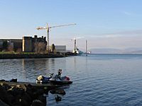
The inner firth seen from the Cowal peninsula near Dunoon, looking towards Greenock. The PS Waverley can be seen cruising.


Nature and Wildlife
| Clyde Sill MPA(NC) | |
|---|---|

Location and extent of the Clyde Sill MPA in the Firth of Clyde
|
|
| Location | Firth of Clyde, Scotland |
| Area | 712 km2 (275 sq mi) |
| Designation | Scottish Government |
| Established | 2014 |
| Operator | Marine Scotland |
On Great Cumbrae, there is a marine biological station. It is run by the University of Glasgow and the University of London. Scientists here study sea life.
You can often see common and grey seals in the firth. Harbour porpoises are also common. While dolphins are rarer, some were seen in the upper firth in 2005.
Also in 2005, the firth had the second-highest number of basking shark sightings in Scotland. These huge, gentle sharks seem to like the warm, shallow waters around Pladda.
In the past, there was a lot of commercial fishing in the Firth. Today, the main catches are prawns, lobsters, herring, mussels, and crayfish.
In September 2008, Scotland's first No Take Zone (NTZ) was created in Lamlash Bay, on the Isle of Arran. This was thanks to a local group called the Community of Arran Seabed Trust (C.O.A.S.T). The NTZ protects delicate sea life, like maerl. Maerl is a very slow-growing red algae that looks like coral. It grows only about 1 mm (0.04 inches) per year! Maerl beds are important homes for many different sea creatures. They are also vital nurseries for young scallops and fish. Studies show that scallop dredging and waste from fish farms harm maerl. Dredging can kill over 70% of live maerl. It takes many years for maerl beds to recover without disturbance.
In 2014, a large area of sea (712 square kilometers or 275 square miles) at the mouth of the firth was made a Nature Conservation Marine Protected Area. It's called the Clyde Sill MPA(NC). This area is special because the warmer, fresher water from the Clyde mixes with cooler, saltier water. This creates a rich environment for tiny sea plants and animals (plankton). These plankton then feed fish, which are eaten by bigger marine animals and seabirds.
Shipping and Ports
The Firth of Clyde has always been important for shipbuilding and shipping. Upriver, there were shipbuilding centers in Glasgow, Govan, Clydebank, Dumbarton, and Renfrew. Downriver, there were big shipyards in Greenock and Port Glasgow. Smaller yards were in Irvine, Ardrossan, Troon, and Campbeltown. Today, the Ferguson Marine shipyard in Port Glasgow is the last merchant shipbuilder on the Clyde. It is owned by the Scottish Government. In Greenock, the large Inchgreen dry dock is sometimes used for ship repair.
The Firth of Clyde has one of the deepest sea entrances in Northern Europe. This means it can handle the biggest cargo ships in the world. Because of this, the Clyde is one of the UK's top ports, handling about 7.5 million tonnes of cargo each year. The Hunterston Terminal was built to bring in bulk ore, but now mostly handles coal imports. Huge supertankers (up to 324,000 tonnes) travel up the firth to deliver crude oil to the Finnart Oil Terminal in Loch Long. This oil then goes by pipeline to the Grangemouth Refinery. Another pipeline brings refined oil products back for export.
Greenock's Ocean Terminal handles cargo from smaller container ships. In recent years, many cruise liners have started visiting, making the port very busy during tourist season. There are plans to build a huge new container terminal at Hunterston. This could become a major port for northern Europe.
The Royal Navy has a significant presence on the Clyde. They have bases at HMNB Clyde on the Gare Loch and on Loch Long. These are connected to nuclear storage facilities. One of the main ports that supports naval ships is in Greenock.
-
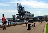
Container cranes at Greenock's Ocean Terminal, with the cruise ship Golden Princess docked.
-
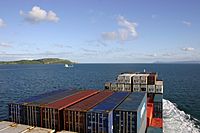
A container ship leaving the Clyde Estuary. Little Cumbrae is on the left.


Lighthouses and Beacons

Lighthouses help guide ships safely. You can find lighthouses at:
- Cloch Point on the Inverclyde coast.
- Toward Point Lighthouse at the southern tip of the Cowal Peninsula.
- Little Cumbrae
- Pladda
Navigation beacons also help ships find their way. There is one at:
- The Gantocks Rocks and Navigation Beacon, off the coast at Dunoon.
See also
 In Spanish: Fiordo de Clyde para niños
