
Clydebank facts for kids
Quick facts for kids Clydebank
|
|
|---|---|
| Town | |
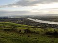
 View of Clydebank from Kilpatrick Hills |
|

Clydebank
|
|
| Area | 8.74 km2 (3.37 sq mi) |
| Population | 25,620 (2020) |
| • Density | 2,931/km2 (7,590/sq mi) |
| OS grid reference | NS500700 |
| • Edinburgh | 47 mi (76 km) |
| • London | 350 mi (560 km) |
| Lieutenancy area | |
| Country | Scotland |
| Sovereign state | United Kingdom |
| Post town | CLYDEBANK |
| Postcode district | G81 |
| Dialling code | 0141 & 01389 |
| Ambulance | Scottish |
| EU Parliament | Scotland |
| UK Parliament | |
| Scottish Parliament |
|
Clydebank (which is Bruach Chluaidh in Scottish Gaelic) is a town in West Dunbartonshire, Scotland. It sits on the north side of the River Clyde. To its west is the village of Old Kilpatrick, and to its east are the Yoker and Drumchapel areas of Glasgow. Some nearby areas like Duntocher, Faifley, and Hardgate are either part of Clydebank or just outside it. Beyond these areas are the Kilpatrick Hills.
Clydebank was officially started as a "police burgh" (a type of town with its own local government) on November 18, 1886. Historically, it was part of Dunbartonshire. Today, it's part of the larger city area known as Greater Glasgow.
Contents
Discovering Clydebank's Past
Ancient Roots and Roman History
Clydebank is located in an area that was once part of the ancient Kingdom of Strathclyde. A local story says that the nearby village of Old Kilpatrick is where Saint Patrick, the patron saint of Ireland, was born.
The town also includes parts of the Antonine Wall. This was a huge wall built by the Roman Empire across Scotland. One of the forts along this wall was located near Hardgate/Duntocher. In 2008, the Antonine Wall became a World Heritage Site. This means it's a very important historical place for everyone to protect.
Before the 1870s, the area where Clydebank now stands was mostly countryside. There were small villages, farms, and a few small businesses like mining and paper mills.
How Industry Shaped Clydebank

Clydebank began to grow in the 1870s because of the shipbuilding industry. A company called J & G Thomson needed a new place for their shipyard. They chose land on the north bank of the River Clyde, which was perfect for building large ships. The land was also close to the Forth and Clyde Canal and a main road, making it easy to move materials and workers. Building of the new shipyard started on May 1, 1871.
At first, workers traveled to the shipyard by paddle steamer. But soon, the company started building flats for the workers to live in. These first homes were known as "Tamson's (Thomson's) Buildings."
As the shipyard got bigger, more buildings appeared. Houses, a school, and churches were built. Other businesses also moved to the area. By 1880, about 2,000 men were living and working there.

In 1882, a railway line was built to connect Glasgow to the new shipyard. Then, between 1882 and 1884, the Singer Manufacturing Company built a huge sewing machine factory nearby. More people moved to the area, and in 1886, the growing community asked to become an official town. They named the new town Clydebank, after the shipyard that helped it grow.
The Clydebank Blitz
During World War II, on March 13 and 14, 1941, German bombers attacked Clydebank. This event is known as the Clydebank Blitz. The town was badly damaged. Shipyards, an oil depot, and the Singer factory were also hit. Sadly, 528 people were killed and over 617 were seriously injured during these two days.
Clydebank's Location and Layout
Clydebank is located in the west of Scotland, on the north side of the River Clyde. It's part of the larger Greater Glasgow area, about 6.5 miles (10.5 km) northwest of Glasgow city centre.
Before the late 1800s, Clydebank was a rural area. But as shipbuilding grew, it quickly became a town. It grew so much that it absorbed older nearby settlements like Dalmuir and Kilbowie.
Local Areas of Clydebank
The Linnvale housing area was rebuilt after being destroyed during the Clydebank Blitz. Its new streets were named after members of the Labour government at the time. Linnvale has a primary school and a church.
Whitecrook is another area in the town. It has two primary schools and a Hospice called St Margaret's. There are also local parks and sports clubs, including Clydebank Rugby Club.
Who Lives in Clydebank?
Clydebank doesn't have strict official borders for its population count anymore. However, for the 2011 UK Census, the main town centre and surrounding areas were counted. This included places like Dalmuir, Drumry, and Kilbowie.
In 2011, Clydebank had a population of 28,799 people. Most residents (93%) were White Scottish. About 63.7% of the population identified as Christian, while 28.3% said they had no religion. By mid-2012, the population had slightly decreased to 26,640.
Learning in Clydebank
Clydebank has many schools for different age groups.
Primary Schools
- Cunard School
- Edinbarnet Primary School
- Kilbowie Primary School
- Our Holy Redeemer's Primary School
- St Eunan's Primary School
- St Mary's Primary School
- Linnvale Primary School
- St Stephens Primary School
- Carleith Primary School
- Goldenhill Primary School
- Our Lady of Lorreto Primary School
- Clydemuir Primary School
- Whitecrook Primary School
Secondary Schools
- Clydebank High School
- St Peter the Apostle High School
Further Education
For students who want to continue their education after secondary school, West College Scotland has a campus in Clydebank. This used to be called Clydebank College.
Sports in Clydebank
Clydebank is home to two semi-professional football teams: Clydebank F.C. and Yoker Athletic F.C.. Both teams now play in the West of Scotland Football League. The original Clydebank F.C. club was sold in 2002, but a new Clydebank F.C. was formed in 2003. They now share a ground with Yoker Athletic.
Clydebank also has a Rugby Football Club based in Whitecrook. It was started in 1969. Other sports clubs include Singer's Football Club, the Clydesdale Harriers (Scotland's first amateur athletics club), and the Lomond Roads Cycling Club.
The Antonine Sports Centre in Duntocher offers various sports activities. It's a non-profit organization run by volunteers.
Jobs and Work in Clydebank

Clydebank has a moderate unemployment rate, but about 20% of the population face challenges finding work.
One of the biggest employers in Clydebank was the John Brown & Company shipyard. This famous shipyard built many well-known ships, including the RMS Lusitania, Queen Mary, Queen Elizabeth, and Queen Elizabeth 2. They also built the warship HMS Hood. The shipyard closed in 2000. Now, the area has been redeveloped with new attractions like the Titan Clydebank Crane and a new campus for West College Scotland.
The Singer Corporation was another major employer, providing thousands of jobs. The sewing machine factory closed in 1980. The Clydebank Business Park now stands where the factory used to be.
The town also has the independent Clydebank Co-operative Society, which runs several shops.
Famous People from Clydebank
Many notable people have connections to Clydebank:
- Duncan Bannatyne – A Scottish entrepreneur and author.
- Kevin Bridges – A popular stand-up comedian.
- James Cosmo – A Scottish actor, born in Clydebank.
- Patsy Gallacher – A famous footballer.
- Kevin Gallacher – Also a former footballer, and Patsy's grandson.
- Fulton Mackay – An actor.
- Jimmy McCulloch – A guitarist known for his work with the band Wings.
- John McGinn – A professional footballer.
- Ian McHarg – A landscape architect who was born in Clydebank.
- Jimmy Reid – A politician and leader of the famous "work-in" in the 1970s.
- Barbara Rafferty – An actress.
- Mary Riggans – An actress known for Balamory.
- Ian Tough – An entertainer, part of The Krankies duo.
- Wet Wet Wet – A pop band formed in Clydebank in 1982. The band's bass player, Graeme Clark, once said that for young people in Clydebank in the 1980s, "It was either crime, the dole, football, or music...and we chose music."
Getting Around Clydebank

Clydebank has several train stations, including Clydebank, Drumry, Dalmuir, Yoker, Kilpatrick, and Singer. Buses connect the town to Glasgow, Dumbarton, and other nearby areas. The main bus stop is at the Clyde Shopping Centre.
In the past, Clydebank was part of Glasgow's large tramway system. The last tram service in Clydebank ended on September 6, 1962.
The Erskine Bridge near Old Kilpatrick connects the A82 road (which goes around Clydebank) to the M8 motorway. This motorway links Clydebank to places like Greenock, Glasgow Airport, and Paisley, and the rest of Scotland's road network.
Images for kids
-
View of Clydebank from Kilpatrick Hills
See also
 In Spanish: Clydebank para niños
