G postcode area facts for kids
Quick facts for kids
Glasgow
|
|
|---|---|
| Country | United Kingdom |
| Postcode area |
G
|
| Postcode area name |
Glasgow
|
| Post towns | 5 |
| Postcode districts | 57 |
| Postcode sectors | 241 |
| Postcodes (live) | 31,804 |
| Postcodes (total) | 46,727 |
| Statistics as at May 2020 | |
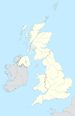
The G postcode area, also known as the Glasgow postcode area, is a special group of codes used for mail in central Scotland. These codes help mail get to the right places in and around the big city of Glasgow. They also cover parts of other areas like West Dunbartonshire (including Dumbarton, Clydebank and Alexandria), plus parts of Argyll and Bute (like Arrochar and Helensburgh), East Dunbartonshire, North Lanarkshire, South Lanarkshire, East Renfrewshire, and Stirling.
Contents
How Postcodes Started in Glasgow
Before the current postcode system began in the late 1960s, Glasgow had its own way of sorting mail. From 1923, the city was split into different areas. These areas had codes like C1 for the city centre, W1 for the west, N1 for the north, and E1 for the east. For example, the old C1 area is now covered by the G1 postcode. This old system helped deliver mail, but it was later replaced by the national postcode system we use today.
Where Each Postcode Goes
The G postcode area is divided into many smaller districts. Each district covers a specific part of Glasgow or the surrounding areas. This table shows you which areas belong to each G postcode.
| Postcode district | Post town | Coverage | Local authority area(s) |
|---|---|---|---|
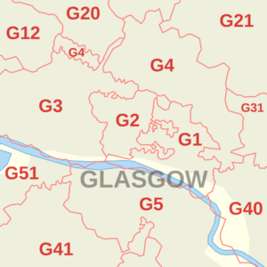
| G1 | GLASGOW | Merchant City | Glasgow City |
| G2 | GLASGOW | Blythswood Hill, Anderston (part) | Glasgow City |
| G3 | GLASGOW | Anderston, Finnieston, Garnethill, Park, Woodlands (part), Yorkhill | Glasgow City |
| G4 | GLASGOW | Calton (part), Cowcaddens (part), Drygate, Kelvinbridge, Townhead, Woodlands (part), Woodside (part) | Glasgow City |
| G5 | GLASGOW | Gorbals | Glasgow City |
| G9 | GLASGOW | Used for Newspaper Competitions | Not tied to a specific place |
| G11 | GLASGOW | Broomhill, Partick, Partickhill | Glasgow City |
| G12 | GLASGOW | West End (part), Cleveden, Dowanhill, Hillhead, Hyndland, Kelvindale, Kelvinside, Botanic Gardens, University of Glasgow | Glasgow City |
| G13 | GLASGOW | Anniesland, Knightswood, Yoker | Glasgow City |
| G14 | GLASGOW | Whiteinch, Scotstoun | Glasgow City |
| G15 | GLASGOW | Drumchapel | Glasgow City |
| G20 | GLASGOW | Maryhill, North Kelvinside, Ruchill | Glasgow City |
| G21 | GLASGOW | Balornock, Barmulloch, Cowlairs, Royston, Springburn, Sighthill | Glasgow City |
| G22 | GLASGOW | Milton, Parkhouse, Possilpark | Glasgow City |
| G23 | GLASGOW | Lambhill, Summerston | Glasgow City |
| G31 | GLASGOW | Dennistoun, Haghill, Parkhead (part) | Glasgow City |
| G32 | GLASGOW | Carmyle, Tollcross, Mount Vernon, Lightburn, Sandyhills, Shettleston, Springboig | Glasgow City |
| G33 | GLASGOW | Cardowan, Carntyne, Craigend, Cranhill, Garthamlock, Millerston, Provanmill, Queenslie, Riddrie, Robroyston, Ruchazie, Stepps, Wellhouse | North Lanarkshire, Glasgow City |
| G34 | GLASGOW | Easterhouse, Easthall, Provanhall | Glasgow City |
| G40 | GLASGOW | Bridgeton, Calton, Dalmarnock | Glasgow City |
| G41 | GLASGOW | Pollokshields, Shawlands | Glasgow City |
| G42 | GLASGOW | Battlefield, Govanhill, Mount Florida, Strathbungo (part), Toryglen | Glasgow City |
| G43 | GLASGOW | Mansewood, Newlands, Pollokshaws, Cowglen | Glasgow City |
| G44 | GLASGOW | Cathcart, Simshill, Croftfoot, King's Park, Muirend, Netherlee | Glasgow City, East Renfrewshire |
| G45 | GLASGOW | Castlemilk | Glasgow City |
| G46 | GLASGOW | Arden, Carnwadric, Deaconsbank, Giffnock, Kennishead, Thornliebank, northeast Newton Mearns, Regents Park | East Renfrewshire, Glasgow City |
| G51 | GLASGOW | Govan, Ibrox, Drumoyne, Cessnock, Plantation | Glasgow City |
| G52 | GLASGOW | Cardonald, Hillington, Penilee, Mosspark | Glasgow City |
| G53 | GLASGOW | Darnley, Pollok, Crookston, Parkhouse, Priesthill, Nitshill, Southpark | Glasgow City |
| G58 | GLASGOW | Used by National Savings and Investments in Cowglen | Not tied to a specific place |
| G60 | GLASGOW | Bowling, Old Kilpatrick | West Dunbartonshire |
| G61 | GLASGOW | Bearsden | East Dunbartonshire |
| G62 | GLASGOW | Baldernock, Milngavie, Mugdock | East Dunbartonshire, Stirling |
| G63 | GLASGOW | Balfron, Balmaha, Blanefield, Croftamie, Drymen, Dumgoyne, Fintry, Killearn, Rowardennan, Strathblane | Stirling |
| G64 | GLASGOW | Bishopbriggs, Torrance | East Dunbartonshire |
| G65 | GLASGOW | Croy, Kilsyth, Twechar | North Lanarkshire, East Dunbartonshire |
| G66 | GLASGOW | Clachan of Campsie, Haughhead, Kirkintilloch, Lennoxtown, Lenzie, Milton of Campsie, Auchinloch | East Dunbartonshire, North Lanarkshire |
| G67 | GLASGOW | Cumbernauld (south) | North Lanarkshire |
| G68 | GLASGOW | Cumbernauld (north), Dullatur | North Lanarkshire |
| G69 | GLASGOW | Baillieston, Bargeddie, Chryston, Garrowhill, Gartcosh, Gartloch, Moodiesburn, Muirhead, Springhill | Glasgow City, North Lanarkshire |
| G70 | GLASGOW | Used by HM Revenue and Customs in Cumbernauld | Not tied to a specific place |
| G71 | GLASGOW | Birkenshaw, Bothwell, Broomhouse, Tannochside, Uddingston, Viewpark | Glasgow City, North Lanarkshire, South Lanarkshire |
| G72 | GLASGOW | Blantyre, Cambuslang | South Lanarkshire |
| G73 | GLASGOW | Rutherglen | South Lanarkshire |
| G74 | GLASGOW | East Kilbride (north), Thorntonhall | South Lanarkshire |
| G75 | GLASGOW | Auldhouse, East Kilbride (south) | South Lanarkshire |
| G76 | GLASGOW | Busby, Carmunnock, Clarkston, Eaglesham, Waterfoot | East Renfrewshire, Glasgow City, very small parts of South Lanarkshire |
| G77 | GLASGOW | Newton Mearns | East Renfrewshire |
| G78 | GLASGOW | Barrhead, Neilston, Uplawmoor | East Renfrewshire, very small parts of East Ayrshire and North Ayrshire |
| G79 | GLASGOW | Used by HM Revenue and Customs in East Kilbride | Not tied to a specific place |
| G81 | CLYDEBANK | Dalmuir, Duntocher, Faifley, Hardgate | West Dunbartonshire |
| G82 | DUMBARTON | Cardross, Milton, Renton | West Dunbartonshire, Argyll and Bute |
| G83 | ALEXANDRIA; ARROCHAR | Alexandria, Arrochar, Aldochlay, Ardlui, Balloch, Bonhill, Gartocharn, Inverarnan, Jamestown, Luss, Tarbet | West Dunbartonshire, Argyll and Bute, Stirling |
| G84 | HELENSBURGH | Clynder, Cove, Garelochhead, Kilcreggan, Rhu, Rosneath, Shandon | Argyll and Bute |
| G90 | GLASGOW | Used by the Department for Work and Pensions | Not tied to a specific place |
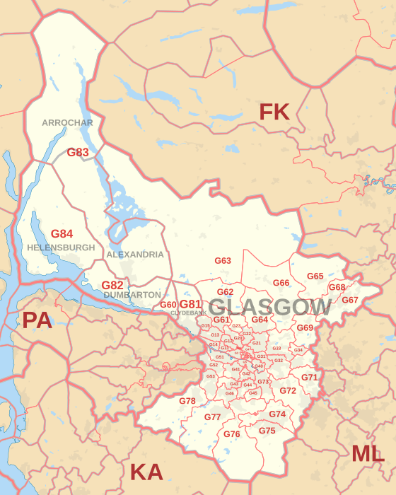
Map of the G Postcode Area
This map helps you see exactly where each G postcode district is located.
More to Explore
- Postcode Address File
- List of postcode areas in the United Kingdom
 | Aaron Henry |
 | T. R. M. Howard |
 | Jesse Jackson |


