
Crookston, Glasgow facts for kids
Quick facts for kids Crookston
|
|
|---|---|
 Crookston Bowling Club |
|

Crookston
|
|
| OS grid reference | NS518636 |
| Council area | |
| Lieutenancy area |
|
| Country | Scotland |
| Sovereign state | United Kingdom |
| Post town | GLASGOW |
| Postcode district | G52 3 / G53 7 |
| Dialling code | 0141 |
| Ambulance | Scottish |
| EU Parliament | Scotland |
| UK Parliament | |
| Scottish Parliament | |
Crookston (Scottish Gaelic: Baile Cruic, Scots: Cruixtoun) is a residential area located on the southwestern edge of Glasgow, Scotland.
It's interesting because there are actually two different parts of Crookston. These two areas are about 1 mile apart and are separated by a river called the White Cart Water. Even though they are distinct, they both use the name Crookston because of how they grew over time. Both areas share the main road, A736 Crookston Road. They also belong to the same areas for the U.K. and Scottish Parliament. However, for local city council matters, the northern part is in the Cardonald area, and the southern part is in the Greater Pollok area.
Contents
Discovering Crookston's Past
Crookston has a long and interesting history, stretching back many centuries.
The Story of Crookston Castle and Estate
The name Crookston comes from a lord named Robert Croc. He was given this land in 1170 by David I of Scotland. Robert Croc quickly built Crookston Castle (Dùn Cruic in Scottish Gaelic) on a small hill. The first castle was made of wood. Later, around 1400, John Stewart of Darnley built the stone castle we see today.
Robert Croc also built a chapel and a hospital. This started a tradition of healthcare in the area that continues even now. The land around the castle was once a forest called Crookston Wood. Ancient remains from the Iron Age were found there in 1959. Several farms also shared the Crookston name, like Crookston House and Mains of Crookston.
The castle lost its importance after being captured in the mid-1500s. However, it was fixed up in the mid-1800s by the Maxwells of Pollok. In 1931, they gave the castle to the National Trust for Scotland. It was the very first property the Trust took care of!
The Crookston Station Area
Even though other nearby places had different names, Crookston was still well-known. So, in 1885, a new train station was named Crookston. This station was part of a new railway line between Glasgow and Paisley. It was built near the White Cart river and the main road.
Over the next few decades, a small community grew around the station. People built many large houses there, and this area became known as Crookston. In 1926, Glasgow took over these lands. The area then became surrounded by other neighborhoods like South Cardonald and Hillington. Many different types of houses were built here over time.
The original train station buildings were abandoned when the line closed in 1983. However, the line reopened in 1990. Now, it uses only one track for trains going both ways. There is a hotel and local shops on Crookston Road. Churches and bowling clubs are also nearby. One of the oldest buildings is Cardonald Place Farm. The local community group for this area is called South Cardonald and Crookston CC.
The Leverndale and Southern Crookston Area
In 1895, a large hospital was built near the White Cart river. It was first known as Govan District Asylum, then Hawkhead Asylum. Later, in 1964, it was renamed Leverndale Hospital. This hospital grew over time. In the 2000s, some of the older hospital buildings were turned into private homes. In 2011, a station for the Scottish Ambulance Service opened here. A special unit for mothers and babies also moved to Leverndale in 2014.
In 1906, a large building called Renfrewshire Combination Poorhouse was built near Old Crookston Farm. It later became Crookston Home Poor Law Institution. In 1934, it was changed into a nursing home for older people. A few years later, 'cottage homes' were built nearby. These were an early type of sheltered housing.
Around the same time, Glasgow bought a large area of land from the Pollok Estate. After World War II, many houses were built here, creating the large Pollok housing area. This new development surrounded Crookston Castle and covered old woodlands and farms.
Unlike Leverndale, the Crookston Home facility closed in the 1990s. The site was then cleared and new houses were built there. From the 1990s to the 2010s, many new suburban houses were added along Crookston Road. This filled most of the land along Glasgow's western border.
Even with many family homes, there are no primary schools directly in this southern area. The closest ones are in west Pollok. Older students usually go to Rosshall Academy or Lourdes Secondary. St Paul's High School is also close for some.
This southern part of Crookston doesn't have one main center. However, the crossroads at Bullwood Drive and Dalmellington Road is a busy spot. Here you'll find a supermarket, a chemist, the Crookston Medical Centre, and the Crookston Bowling Club. The bowling club started in the 1940s for workers at the Rolls-Royce factory.
A local group called Crookston Community Group helps people in the area. While much of Pollok faces economic challenges, Crookston is different. Many large and grand homes have been built here, especially around Leverndale. A new care home for the elderly, Meadowburn Home, opened in 2019 near where Crookston Home used to be.
Most major services are in the center of Pollok. This includes a library, health center, and sports center. The Silverburn Centre is also there, with many shops, restaurants, and a cinema. The local community council for this area is Hurlet and Brockburn CC.
How Crookston Got Its Name
Developers have used many different names for the new housing areas and streets in Crookston, like Raeswood, Castlewood, and Parklands. However, none of these names have become the common name for the whole community. The media still uses 'Crookston' when talking about events in any part of the area.
Even though the two parts of Crookston have different histories and locations, official sources don't use terms like 'North Crookston' or 'South Crookston'.
Getting Around Crookston
Public transport makes it easy to travel in and out of Crookston.
The First Glasgow number 3 bus travels along Crookston Road. It connects Glasgow's West End, the city centre, Silverburn, and Govan. The number 9 bus service runs between Paisley and Glasgow, going through Paisley Road West.
Trains from Crookston station run every half hour. On Sundays, they run hourly. If you're in the southernmost parts of Crookston, the closest train station is Nitshill. This station is about 1 mile from Barrhead Road.
The southern neighborhood is also about 1 mile from Junction 2 of the M77 motorway. This motorway connects Glasgow to Ayrshire. The northern neighborhood is a bit further from Junction 25 of the M8 motorway, which links Glasgow Airport and Edinburgh.
Famous People from Crookston
Some well-known people have lived in or are connected to Crookston:
- Iain Connell, a writer and actor
- Mary Lee, a singer
- Jack Milroy, a comedian
Images for kids
-
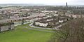
View from Crookston Castle towards west Pollok, Leverndale and Crookston Road (2005)
-
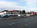
Motor trading business on Paisley Road West, just within Glasgow at its boundary with Ralston, Renfrewshire
-
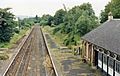
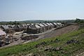
Abandoned buildings (now converted to houses) and tracks at Crookston railway station (1986)
-
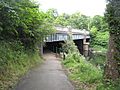
View of the White Cart Water at Howford Bridge from NCR 7 which runs beneath it
-
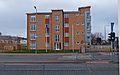
Modern apartment block near Leverndale
-
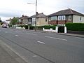
View of some of the older houses at the southern end of Crookston Road
-
New housing under construction at Raeswood, 2016
-
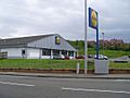
Lidl at Dalmellington Road


_geograph-3117502-by-Ben-Brooksbank.jpg)

.jpg)

.jpg)

