
North Lanarkshire facts for kids
Quick facts for kids
North Lanarkshire
North Lanrikshire
Siorrachd Lannraig a Tuath |
|||
|---|---|---|---|
 |
|||
|
|||
| Sovereign state | United Kingdom | ||
| Country | Scotland | ||
| Lieutenancy areas | Lanarkshire (Part) Dunbartonshire (Part) |
||
| Admin HQ | Motherwell | ||
| Government | |||
| • Body | North Lanarkshire Council | ||
| Area rank | Ranked | ||
| • Rank | Ranked | ||
| ONS code | S12000050 | ||
| ISO 3166 code | GB-NLK | ||


North Lanarkshire is one of the 32 main areas in Scotland. It's like a big county or region. It sits just northeast of Glasgow, a very large city. Many towns and villages here are close to Glasgow. People often travel from North Lanarkshire to work in Glasgow.
This area also shares borders with other regions. These include East Dunbartonshire, Falkirk, Stirling, South Lanarkshire, and West Lothian. North Lanarkshire was created in 1996. Its main office is in the town of Motherwell.
Contents
History of North Lanarkshire
North Lanarkshire has a long and interesting past. Most of the area used to be part of a historic county called Lanarkshire. This county has been around since the 1100s. Its name came from the town of Lanark, which is now in South Lanarkshire.
Old Counties and Towns
Before 1975, parts of North Lanarkshire belonged to different counties. Cumbernauld was in Dunbartonshire. Kilsyth was part of Stirlingshire. Over time, several towns in the area grew big enough to become "burghs." A burgh was a town with special rights and its own local government.
The burghs in this area were:
- Airdrie
- Coatbridge
- Cumbernauld (became a burgh in 1968)
- Kilsyth
- Motherwell and Wishaw (these two towns joined together in 1920)
Industrial Growth and Change
The population of North Lanarkshire grew very fast during the Industrial Revolution. This was a time when new machines and factories changed how people worked. In the 1700s, towns like Motherwell made a lot of textiles (cloth).
Later, in the 1800s, people found coal and iron in the area. This discovery changed everything. The building of the railway from Glasgow to Edinburgh also helped. Towns like Motherwell, Coatbridge, and Wishaw became major centers for making iron and steel.
Modern Changes
In the second half of the 1900s, the iron and steel industries started to slow down. But new types of jobs appeared. These included finance, technology, and transport services. The town of Cumbernauld grew very quickly after World War II. It is now the largest town in North Lanarkshire.
Many people also moved to the southwestern part of North Lanarkshire. They live there and travel to work in Greater Glasgow. This area has become a popular place for commuters.
How North Lanarkshire Was Formed
The North Lanarkshire council area was officially created in 1996. This was part of a big change to local government in the United Kingdom. Before 1996, the area was part of a larger region called Strathclyde.
When North Lanarkshire was formed, it combined several smaller districts. These included Cumbernauld and Kilsyth, Monklands, Motherwell, and part of Strathkelvin. This change made North Lanarkshire a single authority. It became responsible for all local services.
Geography of North Lanarkshire
North Lanarkshire is located in the Central Lowlands of Scotland. This is a flatter area in the middle of the country. It lies to the east of the city of Glasgow.
Rivers and Hills
The area sits on Scotland's main watershed. This means that some rivers flow west and others flow east. The River Clyde flows through the western part of the area. It eventually reaches the Irish Sea. The River Almond flows east. It empties into the Firth of Forth near Edinburgh. The northern parts of North Lanarkshire have forests and higher areas. These include the Kilsyth Hills.
Population and People
The most people in North Lanarkshire live in the urban southwest. This area is part of the larger Glasgow metropolitan area. The northern and eastern parts of the region are more rural. Here, you will find farms that raise dairy cows and other animals.
The table below shows the different ethnic groups living in North Lanarkshire over the years. It helps us understand how the population has changed.
| Ethnic Group | 2001 | 2011 | 2022 | |||
|---|---|---|---|---|---|---|
| Number | % | Number | % | Number | % | |
| White: Total | 317,026 | 98.74% | 330,679 | 97.91% | 327,207 | 95.96% |
| White: Scottish | 304,784 | 94.93% | 313,356 | 92.78% | 302,736 | 88.79% |
| White: Other British | 6,954 | 2.17% | 7,892 | 2.34% | 12,267 | 3.60% |
| White: Irish | 3,188 | 0.99% | 4,394 | 1.30% | 3,188 | 0.93% |
| White: Gypsy/Traveller | – | – | 205 | 0.06% | 131 | – |
| White: Polish | – | – | 3,009 | 0.89% | 5,357 | 1.57% |
| White: Other | 2,100 | 0.65% | 1,823 | 0.54% | 3,526 | 1.03% |
| Asian, Asian Scottish or Asian British: Total | 3,122 | 0.97% | 5,385 | 1.59% | 8,328 | 2.44% |
| Asian, Asian Scottish or Asian British: Indian | 527 | 0.16% | 997 | 0.30% | 1,487 | 0.44% |
| Asian, Asian Scottish or Asian British: Pakistani | 1,756 | 0.55% | 3,003 | 0.89% | 5,024 | 1.47% |
| Asian, Asian Scottish or Asian British: Bangladeshi | 19 | – | 42 | – | 75 | – |
| Asian, Asian Scottish or Asian British: Chinese | 607 | 0.19% | 898 | 0.27% | 1,103 | 0.32% |
| Asian, Asian Scottish or Asian British: Asian Other | 213 | 0.07% | 445 | 0.13% | 638 | 0.19% |
| Black, Black Scottish or Black British | 45 | – | – | – | – | – |
| African: Total | 92 | – | 532 | 0.16% | 1,853 | 0.54% |
| African: African, African Scottish or African British | – | – | 523 | 0.15% | 227 | 0.07% |
| African: Other African | – | – | 9 | – | 1,626 | 0.48% |
| Caribbean or Black: Total | – | – | 171 | 0.05% | 236 | 0.07% |
| Caribbean | 59 | – | 83 | – | 80 | – |
| Black | – | – | 77 | – | 15 | – |
| Caribbean or Black: Other | – | – | 11 | – | 138 | – |
| Mixed or multiple ethnic groups: Total | 479 | 0.15% | 708 | 0.21% | 2,130 | 0.62% |
| Other: Total | 244 | 0.08% | 252 | 0.07% | 1,219 | 0.36% |
| Other: Arab | – | – | 134 | – | 484 | 0.14% |
| Other: Any other ethnic group | – | – | 118 | – | 735 | 0.22% |
| Total: | 321,067 | 100.00% | 337,727 | 100.00% | 340,973 | 100.00% |
Towns and Villages
North Lanarkshire is home to many towns and villages. The largest town is Cumbernauld. In 2022, about 58,000 people lived there. Other big towns include Coatbridge, Airdrie, and Motherwell.
Here is a list of the largest towns and villages by population:
| Settlement | Population (2020) |
|---|---|
| Cumbernauld | 50530 |
| Coatbridge | 43950 |
| Airdrie | 36390 |
| Motherwell | 32840 |
| Wishaw | 30050 |
| Bellshill | 19700 |
| Viewpark | 15830 |
| Kilsyth | 10380 |
| Shotts | 8630 |
| Stepps | 7700 |
| Chapelhall | 7140 |
| Moodiesburn | 6830 |
| Newarthill | 6720 |
| New Stevenston | 6070 |
| Newmains | 5430 |
| Holytown | 5100 |
| Carfin | 3870 |
| Bargeddie | 3210 |
| Cleland | 3150 |
| Chryston | 3100 |
Fun Places to Visit
North Lanarkshire has many interesting places for people to visit. These include parks, museums, and historic sites. You can learn about the past or enjoy nature.
- Airdrie Public Observatory
- Antonine Wall: Croy Hill and Westerwood Roman fort
- Arria Statue
- Auchinstarry Quarry
- Bedlay Castle
- Bothwellhaugh Roman Fort
- Cambusnethan House
- Carfin Grotto
- Carron Valley Reservoir
- Colzium
- Dalzell House
- Dalziel Park
- Drumpellier Country Park
- Duncarron
- Greenhead Moss
- Jerviston
- M&D's
- Mosswater Local Nature Reserve
- North Lanarkshire Heritage Centre
- Palacerigg Country Park
- Ravenscraig Regional Sports Facility
- Strathclyde Country Park
- Summerlee Museum of Scottish Industrial Life
- The Time Capsule
- World of Wings
Images for kids
-
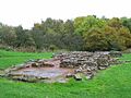
Remains of a roman bath house near the Bothwellhaugh Roman Fort


How North Lanarkshire is Governed
North Lanarkshire is run by the North Lanarkshire Council. This council is made up of elected members. They make decisions about local services. These services include schools, roads, and parks.
Who Represents North Lanarkshire?
People from North Lanarkshire are represented in different governments.
- MPs: These are Members of Parliament. They represent the area in the UK Parliament in London.
- MSPs: These are Members of the Scottish Parliament. They represent the area in the Scottish Parliament in Edinburgh.
These representatives work to make sure the voices of people in North Lanarkshire are heard.
See also
 In Spanish: North Lanarkshire para niños
