
West Lothian facts for kids
Quick facts for kids
West Lothian
Wast Lowden Lodainn an Iar |
|||
|---|---|---|---|
 |
|||
|
|||
| Sovereign state | United Kingdom | ||
| Country | Scotland | ||
| Lieutenancy area | West Lothian | ||
| Admin HQ | Livingston | ||
| Government | |||
| • Body | West Lothian Council | ||
| Area | |||
| • Total | 165.1 sq mi (427.7 km2) | ||
| Area rank | Ranked 20th | ||
| Population
(2020)
|
|||
| • Total | 182,140 | ||
| • Rank | Ranked 9th | ||
| • Density | 1,102.97/sq mi (425.86/km2) | ||
| ONS code | S12000040 | ||
| ISO 3166 code | GB-WLN | ||
| Largest town | Livingston | ||

West Lothian (which is Wast Lowden in Scots and Lodainn an Iar in Scottish Gaelic) is one of the 32 areas in Scotland that has its own local government. It used to be known as Linlithgowshire until 1925. This area is located on the southern side of the Firth of Forth, which is an estuary (where a river meets the sea).
Most of West Lothian is countryside. However, in the 1800s and 1900s, there was a lot of mining for coal, iron, and oil shale. This mining created special red hills called "bings" that you can still see today. The old main town was Linlithgow, but now the biggest town is Livingston. Other important towns include Bathgate and old mining villages like Armadale and Whitburn.
Contents
- What is West Lothian's Geography Like?
- A Look at West Lothian's History
- Where are the Main Towns and Villages?
- What are the Demographics of West Lothian?
- What are West Lothian's Landmarks and Community Spots?
- How Does West Lothian's Economy Work?
- How Do People Get Around West Lothian?
- What About Education in West Lothian?
- What Sports Can You Play in West Lothian?
- Who are Some Famous People from West Lothian?
- Images for kids
- See also
What is West Lothian's Geography Like?
West Lothian shares borders with several other areas. These include Edinburgh, Scottish Borders, South Lanarkshire, North Lanarkshire, and Falkirk. The area generally rises from lowlands in the north to the Pentland Hills in the southeast. The highest point is West Cairn Hill, which is 562 meters (1,844 feet) tall.
About two-thirds of the land is used for farming. A smaller part, about one-tenth, is covered by towns and cities. Important rivers here are the Almond and the Union Canal. There are also several lochs (lakes) like Linlithgow Loch and Beecraigs Loch.

The ground in West Lothian is mostly made of sedimentary rocks. These rocks were formed from layers of sand and mud over millions of years. There are also volcanic rocks in the Bathgate Hills. You can find oil shale, sandstone, and coal here. Oil shale is a special rock that contains oil, which was extracted in the past.
A Look at West Lothian's History
West Lothian has been home to people for a very long time. Many ancient burial sites have been found, like at Cairnpapple Hill. This site is considered one of Scotland's most important archaeological places. There are also remains of old hill forts on several hills.
Around 83 AD, the Romans came and built roads and forts in the area. After the Romans left, different groups of people lived here. Eventually, in the 11th century, West Lothian became part of the Kingdom of Scotland.

During the Middle Ages, towns like Linlithgow and Torphichen grew. The Knights Hospitaller, a group of knights, even had their Scottish headquarters at Torphichen.
The Industrial Revolution (from about 1760 to 1840) completely changed West Lothian. Deep mines for iron, coal, and oil shale opened. This led to the creation of many new villages. A chemist named James Young discovered how to get paraffin oil from coal. He opened the world's first commercial oil works in Bathgate in 1852. Later, he started getting oil from the more common oil shale.
By 1871, there were over 50 oil works in the area. These industries created the distinctive "bings" – large hills of waste rock. At first, people thought these bings were ugly. Now, they are seen as important reminders of Scotland's industrial past. They are also home to many different plants and animals.
In 1890, the West Lothian County Council was created to manage the area. The name officially changed from "Linlithgowshire" to "West Lothian" in 1925. After the Second World War, heavy industry declined. The last shale oil mine closed in 1962. In 1975, West Lothian's borders were changed. Some parts moved to other areas, and some new areas were added.
Where are the Main Towns and Villages?
The biggest towns in West Lothian by population are:
| Settlement | Population (2020) |
|---|---|
| Livingston | 56840 |
| Bathgate | 23600 |
| Broxburn | 15970 |
| Linlithgow | 12840 |
| Armadale | 12720 |
| Whitburn | 11490 |
| East Calder | 6430 |
| Blackburn | 5730 |
| Fauldhouse | 4900 |
| Winchburgh | 3840 |
What are the Demographics of West Lothian?
West Lothian is home to a diverse population. Most residents are from a White background, with a large number identifying as Scottish. Over the years, the area has seen an increase in people from other parts of the UK, Europe (especially Poland), and Asia.
The total population of West Lothian has grown steadily. In 2001, it was about 158,714 people. By 2022, it had increased to 181,278 people. This growth shows that more and more people are choosing to live in West Lothian.
What are West Lothian's Landmarks and Community Spots?
Famous Landmarks to Visit

- Cairnpapple Hill is an ancient monument with amazing views. It's a very old site where people used to worship.
- Torphichen Preceptory is a 12th-century church. It was once the headquarters for the Knights Hospitaller in Scotland.
- Linlithgow Palace is a beautiful ruined palace. It was a main home for Scottish kings and queens. Mary, Queen of Scots was born here!
- House of the Binns is a historic house from the 1600s. It was the home of the Dalyell family for centuries.
- Hopetoun House is a grand country house with a large estate. It was designed by famous architects. Part of the TV series Outlander was filmed at Midhope Castle on this estate.
Fun Community Facilities

West Lothian has several country parks where you can enjoy nature:
- Beecraigs Country Park is a large park with forests, a visitor centre, and a loch.
- Polkemmet Country Park offers woodlands, river walks, and outdoor activities.
- Almondell and Calderwood Country Park follows the Almond river valley.
- Blawhorn Moss is a special nature reserve. It's a large, undisturbed bog, important for local wildlife.
Museums to Explore
- Museum of the Scottish Shale Oil Industry tells the story of West Lothian's oil shale mining history. It's located near Livingston.
- Bennie Museum in Bathgate shares local history and heritage. It's run by volunteers.
- Linlithgow Museum is another volunteer-run museum. It focuses on the history of Linlithgow.
- Military Museum Scotland in Wilkieston covers Scottish military history.
- Museum of Scottish Railways is a railway museum at the Bo'ness and Kinneil Railway.
How Does West Lothian's Economy Work?
West Lothian has a strong and varied economy. In 2020, there were about 4,500 businesses. These businesses provided nearly 72,000 jobs. The biggest job areas include healthcare, construction, retail, and manufacturing.

Even though mining was once very important, it now accounts for a small number of jobs. Some of the largest private employers are big companies like Sky UK, Tesco, and Mitsubishi Electric. The local council and NHS Scotland are also major employers.
West Lothian is home to the Starlaw distillery in Bathgate, which makes Scotch whisky. Glenmorangie, another whisky company, has offices and a bottling plant in Livingston.
You can find several shopping centres in West Lothian. The biggest ones are in Livingston, including 'The Centre' and Livingston Designer Outlet. These combined make Livingston one of the largest indoor shopping areas in Scotland. The area also has several large wind farms. These farms use wind power to create electricity.
How Do People Get Around West Lothian?
Roads
Major roads connect West Lothian to other parts of Scotland:
- The M9 Motorway passes north of Linlithgow.
- The M8 motorway links Glasgow and Edinburgh. It goes through Livingston and Bathgate.
- The A89 road runs through many towns like Armadale, Bathgate, and Broxburn.
Trains

Several railway lines run through West Lothian, connecting towns to Glasgow and Edinburgh:
- The North Clyde Line stops at Livingston North, Bathgate, and Armadale.
- The Shotts Line serves stations like Fauldhouse, West Calder, and Livingston South.
- The Glasgow–Edinburgh via Falkirk line passes through Linlithgow.
Many old railway lines used to exist for mining. These are now closed. West Lothian has impressive railway bridges called viaducts. The Almond Valley Viaduct is a famous example. It was built in 1842 and is 1.5 miles long with 36 arches. It's even featured in the West Lothian Council logo!
Air Travel
West Lothian does not have its own airport. The closest major airport is Edinburgh Airport.
What About Education in West Lothian?
West Lothian has a good education system. There are 11 secondary schools, 67 primary schools, and many nurseries. For older students, West Lothian College in Livingston offers further education. It has sports facilities, a library, and training restaurants. The college teaches over 8,000 students each year.
Scotland's Rural College (SRUC) has a campus in Livingston. Here, students can learn about farming, animal care, and landscaping. The Scottish Institute of Theatre, Dance, Film and Television also has its main campus in Livingston.
West Lothian has 14 public libraries. There's a special history library in Linlithgow. It has many items about the history of West Lothian.
What Sports Can You Play in West Lothian?

Football is very popular in West Lothian. There are 12 football teams playing in different leagues.
- Livingston F.C. plays at Almondvale Stadium.
- Linlithgow Rose competes in the Lowland Football League.
- Other local clubs include Armadale Thistle, Bathgate Thistle, and Broxburn Athletic.
The West Lothian Sports Council helps many different sports clubs. Rugby is also played by teams like Linlithgow RFC and Livingston RFC. The Edinburgh Monarchs, a speedway team, are based in Armadale. Cricket is played at a local level, for example, at Boghall Cricket Club Ground.
Swimming facilities are available in most towns. Swim West Lothian helps organize local swimming clubs and events.
Who are Some Famous People from West Lothian?
West Lothian has been home to many well-known people:
- Mary Queen of Scots and King James the Fifth were both born at Linlithgow Palace.
- Alex Salmond from Linlithgow was a former First Minister of Scotland.
- Robin Cook and Sir Tom Dalyell were important politicians.
Sports stars include:
- Dario Franchitti (from Whitburn), a four-time Indy Car racing champion.
- Paul di Resta (from Uphall), a racing driver.
- Peter 'Snakebite' Wright (born in Livingston), a world darts champion.
Actors, musicians, and entertainers:
- Susan Boyle (from Blackburn), a singer famous from Britain's Got Talent.
- Lewis Capaldi (from Whitburn and Bathgate), a popular singer/songwriter.
- Leon Jackson (from Whitburn), winner of The X Factor.
- David Tennant (from Bathgate), a famous actor.
Important figures in science and medicine:
- John Fleming (from Bathgate), a naturalist and geologist.
- Sir Charles Wyville Thomson (from Linlithgow), a marine zoologist.
- James Young Simpson, a significant figure in the history of medicine.
Images for kids
-
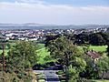
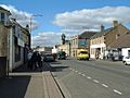
The town of Armadale
-
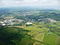
The town of Bathgate seen from the air
-
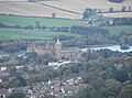
Linlithgow Palace in Linlithgow, seen from Cockleroy Hill
-
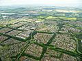
The town of Livingston seen from the air
-
The town of Whitburn


See also
 In Spanish: West Lothian para niños
