
Broxburn facts for kids
Quick facts for kids Broxburn
|
|
|---|---|
 The junction of East and West Main Street in central Broxburn |
|

Broxburn
|
|
| Population | 15,970 (2020) |
| OS grid reference | NT081722 |
| Council area | |
| Lieutenancy area | |
| Country | Scotland |
| Sovereign state | United Kingdom |
| Post town | Broxburn |
| Postcode district | EH52 |
| Dialling code | 01506 |
| Police | Lothian and Borders |
| Fire | Lothian and Borders |
| Ambulance | Scottish |
| EU Parliament | Scotland |
| UK Parliament |
|
| Scottish Parliament |
|
Broxburn (in Scottish Gaelic: Srath Bhroc) is a town in West Lothian, Scotland. It is about 12 miles (19 km) west of Edinburgh. It is also 5 miles (8 km) from Edinburgh Airport and 5 miles (8 km) north of Livingston.
Broxburn started as a small village called Easter Strathbock many years ago. By the 1600s, it became known as Broxburn. The town grew a lot during the Victorian era (when Queen Victoria ruled). This growth was because of the shale oil industry. Today, much of that industry is gone. However, Broxburn has continued to grow with new homes. It now connects with the nearby town of Uphall. Broxburn is just south of Winchburgh.
Contents
What's in a Name?
The name Broxburn comes from "brock's burn." A "brock" is an old Scots word for a European badger. A "burn" is a Scots word for a large stream or small river. So, Broxburn means "badger's stream."
The village was once called Easter Strathbrock. "Strath" means a river valley. The nearby village of Uphall was called Wester Strathbrock.
Broxburn's Story
The village that became Broxburn likely began around 1350. This was when Margery le Cheyne inherited the eastern part of the Strathbrock area. The small settlement that grew around her home was first called Eastertoun.
Easter Strathbrock was burned down in 1443-4 during a conflict. It was destroyed again in 1455 during more fighting. After these troubles, the town was rebuilt. In 1590, Kirkhill House was built for a local landowner. The village was renamed Broxburn in 1600. This new name likely came from another place called Broxburn in East Lothian.
In 1636, Kirkhill House was given to Ludovic Stewart. The house and land later went to the Earls of Buchan. The house was changed a lot in 1770-1771. Kirkhill House still stands in Broxburn today. It is a historic building.
How Broxburn Makes a Living
Looking Back: Old Industries

Broxburn was mainly a farming community for a long time. Then, in the late 1800s, the oil shale industry started. This brought many new workers to the area. The town's population grew very quickly. Broxburn is still known for its link to this industry. It was started by James Young, a famous inventor.
You can still see many large piles of waste from the shale mines around the town. These are called bings.
Until 2013, a food company called Hall's of Broxburn was a major employer. It had about 1,700 workers at its meat processing factory. This factory was the biggest single employer in Broxburn. The large building was taken down in 2014.
The Shale Bings
There are three main Broxburn Bings: Greendikes Bing, Albion Oil Works Bing, and Hopetoun Bing. They are located northeast of Broxburn. The nearby Niddry Bing is close to Winchburgh.
The Greendykes Bing is the largest of the three. If you climb it, you can get great views of the whole area. These bings were formed by huge piles of waste from the shale mines.
Today's Economy
Broxburn now has two industrial areas. These are the Greendykes Industrial Estate and the East Mains Industrial Estate. They offer jobs for local people. Some of the biggest employers include Campbells Prime Meat Limited and Glenmorangie. Broxburn Bottlers Limited also provides many jobs. James Ritchie & Son, a company that makes clocks, has been in Broxburn since 1809.
How Broxburn is Governed
Broxburn is part of the Livingston area for the UK Parliament. It is also part of the Almond Valley area for the Scottish Parliament.
For local government, Broxburn is part of the Broxburn, Uphall and Winchburgh Ward. This ward is part of West Lothian Council. It also includes the nearby villages of Uphall and Winchburgh.
Community Places
The Strathbrock Partnership Centre is a local community building. It has a medical centre, a library, a small museum, and a community centre. The library was renamed the Lex Davidson Library in 2022. This was to honour a local councillor who served the community for 25 years.
The local hospital is St. John's Hospital at Howden in Livingston.
Getting Around
The A89 road runs along the south side of Broxburn. The A899 road goes right through the middle of Broxburn. In town, it is known as East and West Main Street. The closest major highway is the M8.
Broxburn has many bus services. These are run by McGill's Scotland East, Lothian Country, and E&M Horseburgh. SD Travel runs a service between Livingston Centre and Edinburgh. HcL runs local town services within Broxburn and to Uphall.
Lothian Country operates services like:
- 72 - Fauldhouse - Whitburn - Livingston - Broxburn - Winchburgh - Kirkliston
- X18 - Edinburgh - Ratho Station - Broxburn - Uphall - Bathgate - Armadale - Whitburn
- N18 - Edinburgh - Ratho Station - Broxburn - Uphall - Bathgate (Weekend Night Service)
- N43 - Edinburgh - Queensferry - Kirkliston - Broxburn - Dechmont (Night Service)
Trains
Broxburn has good train links to Edinburgh, Livingston, Linlithgow, and Edinburgh Airport. The nearest train station is Uphall Station. From there, you can travel to Edinburgh, Livingston, Bathgate, Airdrie, and Glasgow.
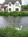
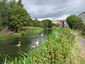
Canal
The Union Canal goes through Broxburn. It is no longer used for transporting goods. Now, people use it for fishing, magnet fishing, and leisure boating. It has a towpath that horses once used to pull canal boats. Today, this towpath is a popular path for dog walkers, bikers, runners, and walkers.
Schools in Broxburn
Broxburn has four state-funded schools:
- Broxburn Primary
- Kirkhill Primary
- St. Nicholas Roman Catholic Primary
- Broxburn Academy
Places of Worship

Broxburn has six churches.
St John Cantius and St Nicholas Catholic Church is a Roman Catholic church. It was built in 1880. The church has a special font from the 1400s or 1500s. It also has an altar made of stone and marble. Next to the church is a hall and a small chapel.
The Broxburn Parish Church was built in 1880. It offers Church of Scotland services.
The St Nicholas United Free Church of Scotland was built in 1890.
Other churches in the town include the New Life Christian Fellowship, Broxburn Baptist Church, and Grace Community Church. There are also other religious groups active in the town.
Sports and Fun
Broxburn is home to the football club Broxburn Athletic. They play in the East of Scotland League.
The town has sports and health facilities for everyone. These include a sports centre, a swimming pool, and bowling clubs. The Binny Golf Club is also nearby.
A motorcycle dirt track was built at The Sports Park in 1928. Some events were held to show off this new sport.
Famous People from Broxburn
- David Erskine and Henry Erskine, who were Earls of Buchan
- James Anderson (a Paralympic swimmer)
- Charles Benham (a cricketer)
- Mark Burchill (a footballer)
- Bill Bann (a footballer)
- James Baird (a footballer)
- Colin Fleming (a tennis player)
- David Fleming (a cricketer)
- Gavin Hamilton (a cricketer)
- Liam Henderson (a footballer)
- John Kerr (a figure skater)
- Shelley Kerr (a football manager)
- Stephen Robson (a Bishop)
- Alexander Steuart (a clock and instrument-maker)
Images for kids
-
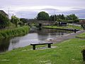
The Union Canal at Broxburn, looking west
-
Union Canal
-
Swans on the canal
-
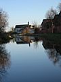
Between Bridges 26 and 27


See also
 In Spanish: Broxburn para niños
