
Antonine Wall facts for kids

The Antonine Wall was a large barrier built by the Romans in Scotland. It was made from stone and turf (which is like grass and soil). This wall stretched across the middle of Scotland, from the Firth of Forth (near modern Edinburgh) to the Firth of Clyde (near Glasgow).
The Antonine Wall is part of a special list called the UNESCO World Heritage Site "Frontiers of the Roman Empire". It shares this important title with Hadrian's Wall in England and a German wall known as the Limes Germanicus.
This wall was the most northern border of the Roman Empire. It was about 39 miles (63 km) long. The wall itself was about ten feet (3 m) high and fifteen feet (5 m) wide. There was also a deep ditch dug on its north side. This was the second of two "great walls" the Romans built in Britain. Its remains are not as easy to see today as those of Hadrian's Wall, which is further south.
Building the Great Wall
Construction of the Antonine Wall began in AD 142. It was ordered by the Roman Emperor Antoninus Pius. The building work took about twelve years to finish. It's thought that the Romans built it to push back against groups of people called the Caledonians. These groups were putting pressure on the Roman borders.
The wall was protected by sixteen forts. There were also many smaller fortlets built between these main forts. To help soldiers move quickly, a road called the Military Way linked all these sites. The soldiers who built the wall made special stone slabs to remember their hard work. These slabs also showed their battles with the "barbarians" (which is what the Romans called people outside their empire). Twenty of these decorative slabs can still be seen today.
Life and Abandonment
Even though it was a big project, the Antonine Wall was only used for about twenty years. After this time, the Roman soldiers were sent back to Hadrian's Wall.
Later, in AD 208, another Emperor named Septimius Severus brought Roman troops back to the wall. He ordered repairs to be made. Because of this, the wall is sometimes called the Severan Wall. However, this new occupation lasted only a few years. The wall was never used as a fortified border again after that.
Over time, much of the wall and its forts have been destroyed. But some parts of it can still be seen today. Many of these remains are now looked after by Historic Scotland. They are also protected by the UNESCO World Heritage Site Committee.
The Antonine Wall was the only time the Roman Empire tried to control land in Scotland.
Images for kids
-
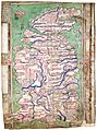
This medieval map by Matthew Paris depicts both the Antonine Wall and Hadrian's Wall towards the top. It dates from circa 1250, more than a thousand years after the Walls' construction. British Library, London.
-
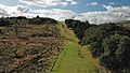
Antonine Wall near Bar Hill showing ditch
-
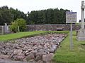
Stone foundation of the Wall in Bearsden, Glasgow
-
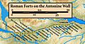
Forts and Fortlets associated with the Antonine Wall from west to east: Bishopton, Old Kilpatrick, Duntocher, Cleddans, Castlehill, Bearsden, Summerston, Balmuildy, Wilderness Plantation, Cadder, Glasgow Bridge, Kirkintilloch, Auchendavy, Bar Hill, Croy Hill, Westerwood, Castlecary, Seabegs, Rough Castle, Camelon, Watling Lodge, Falkirk, Mumrills, Inveravon, Kinneil, Carriden
-
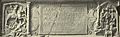
The Bridgeness Slab – the easternmost distance slab
-
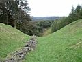
The Antonine Wall, looking east, from Bar Hill between Twechar and Croy
-
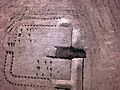
An infrared aerial photograph of Kinneil Roman Fortlet, near Bo'ness at the eastern end of the Antonine Wall.
-
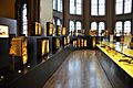
Finds from the Antonine Wall in the Hunterian Museum in Glasgow.


See also
 In Spanish: Muro de Antonino para niños
