
Castlecary facts for kids
Quick facts for kids Castlecary |
|
|---|---|
.jpg) Castlecary from the air |
|

Castlecary
|
|
| OS grid reference | NS783779 |
| Civil parish | |
| Lieutenancy area | |
| Country | Scotland |
| Sovereign state | United Kingdom |
| Post town | GLASGOW |
| Postcode district | G68 |
| Dialling code | 01324 |
| Ambulance | Scottish |
| EU Parliament | Scotland |
| UK Parliament |
|
| Scottish Parliament |
|
Castlecary is a small, old village in North Lanarkshire, Scotland. It is right next to the border with Falkirk. Castlecary has always been important for travel and transport. It is near a river with a bridge, a Roman fort, old roads, and a canal. Later, a Victorian railway bridge and a modern motorway were built here.
Castlecary is close to the town of Cumbernauld. However, it is not officially part of Cumbernauld, just like the nearby villages of Dullatur and Luggiebank. Long ago, around 1725, Castlecary became part of the Cumbernauld church area. This was even though it only had about seventeen families living there. Castlecary is also near Allandale, a village built for workers from Castlecary's old fireclay factories.
Contents
Castlecary's Roman Past

Castlecary has a rich Roman history, like many places in this part of Scotland. The famous Antonine Wall runs right through the village. Around 80 AD, the Romans built a camp here. This might have happened during Governor Agricola's fourth military trip.
Most Roman forts along the wall held about 500 soldiers. Bigger forts like Castlecary had around 1000 soldiers. These forts likely also housed women and children, even though soldiers were not allowed to marry. There were probably large groups of civilians living around the fort too.
Discoveries at the Roman Fort
In 1769, workers digging for the Forth and Clyde Canal found some interesting things. They discovered eight rooms and parts of a bathhouse in the fort's south-east area. Inside the fort walls, they also found human bones, broken pottery, and wild boar tusks.
Sadly, in the past, people did not treat the site with care. They even used gunpowder to clear land for farming. However, in 1902, archaeologists carefully dug up the site.


Many items found at Castlecary can now be seen at the Hunterian Museum in Glasgow. These include an altar dedicated to the Roman god Fortuna. Eleven carved stones have been found at the Castlecary fort. Nine of these were altars. Six of them have the names of Roman army units.
A small sandstone statue of Fortuna, the Roman god of luck, was found in 1771. Fortuna is shown on about 1000 different Roman coins. An altar to the Roman god Mercury was also found. It was made by the Sixth Legion. This small altar is only about 20 by 10 inches. It shows that Italians and Britons worked together in the Roman army. Another altar to an unknown goddess was found when the canal was being dug.


A few coins and parts of a Roman tuba (a type of trumpet) were also found. A pair of small shoes were recovered, suggesting children were at the site. The National Scottish Museums also have a cornu mouthpiece, a piece of a glass cup, an iron hammer, a wooden spatula, and two carved stones. One stone mentions the 'sixth cohort, the century of Antonius Aratus'. More recently, a lion's head treasure was found at Castlecary.
Castlecary's Location and the Antonine Wall
You can see the fort's location on old maps. It is near the Red Burn, the Forth and Clyde Canal, the road, and the old railway station. The canal crosses the Red Burn on an aqueduct, close to the Bonny Water.
Just west of Castlecary, at Garnhall, two Roman temporary camps were found. A round area and a possible watchtower were also discovered, but you cannot see them today. At Tollpark, you can find one of the longest parts of the Antonine Wall that is still visible. This section is between the forts at Castlecary and Westerwood. A small gate behind the local hotel lets you access this part of the wall.

Castlecary's Industrial Past
Castlecary once had two fireclay brickworks. These factories made bricks from a special type of clay.
- Castlecary Fireclay Company Limited (Weir's Castlecary) started in the late 1800s and closed in 1968.
- Stein's Castlecary Works, started by John G Stein, continued until the 1980s.
These two companies were across the road from each other. John Stein's business grew to be the second largest fireclay brick maker in the world. The village of Allandale was built for the workers from these brickworks. Today, the Stein's brickworks site is empty and waiting to be redeveloped. Old film from 1932 shows the Stein family at the Castlecary gala day. In the 1800s, a quarry and a sawmill also provided jobs in the area.
Railway History and Memorials

.jpg)
There have been ideas to build a new "park and ride" railway station where the old brickworks were. It was first suggested to call it Castlecary. However, people asked for it to be called Allandale instead. This was to avoid confusion with a Castle Cary station in Somerset, England.
An old Castlecary railway station used to exist but closed in 1967. This station was the site of a very serious accident. On December 10, 1937, two trains crashed, and 35 people lost their lives. Another 179 people were hurt. A memorial was placed in the village's memorial garden on August 30, 2008. The Castlecary Rail Crash of September 9, 1968, is also remembered there.
Castlecary Today
.jpg)
Today, Castlecary is mostly a residential village with homes. The Castlecary House Hotel is a well-known business here. It is located west of the M80 motorway and south of the canal. The old Roman fort and the castle are east of the M80. This motorway cuts through the village, separating its modern part from much of its history. CMS Windows, a company that employs over 250 people, is based in Castlecary.

Castlecary also gives its name to a large viaduct that crosses the M80 motorway. Its official name is the "Castlecary, Red Burn, Railway Viaduct," or simply Red Burn Viaduct. Many people call this landmark the "Castlecary Arches." It was built for the Edinburgh and Glasgow Railway, which opened in 1842. Before the M80 motorway, the main road went under one of its arches.

The viaduct, along with the nearby Forth and Clyde Canal and the Bonny Water, marks a special language boundary. Around here, the way people speak changes. The "West Central Scots" accent, common in Cumbernauld (which has strong links to Glasgow), shifts to the "East Central Scots" accent. This accent is spoken in nearby towns like Bonnybridge and Denny.
Castlecary Primary School closed sometime between 1973 and 1976. Records from the school's log book during World War II still exist. A new play park for children opened in June 2018.
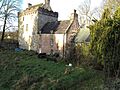
Castle Cary Castle, which is on the other side of the M80 motorway, is part of a local legend. It is said that a woman named Lizzie Baillie jumped from a window there because of love.
Images for kids
-
Castlecary Castle

