Red Burn facts for kids
The Red Burn is a stream that flows from Cumbernauld, a town in Scotland. The name Cumbernauld comes from a Gaelic phrase meaning "the meeting of the waters." Many people agree that the Red Burn is one of these important waters.

Contents
Journey of the Red Burn
The Red Burn starts as a small stream called the Glencryan Burn. It begins near the Fannyside Lochs.
From Source to Reservoir
The Glencryan Burn flows west through the Palacerigg Golf Course. It then becomes bigger when it forms the Glencryan Reservoir. This reservoir is south of Forest Road in Cumbernauld. The stream keeps the name Glencryan Burn until it reaches a place called the Vault Glen.
Through the Vault Glen
The Glencryan Burn enters Cumbernauld near Cumbernauld Academy. It then flows under Forest Road. After this, its name changes to the Red Burn. The river turns sharply east. It is joined by several small streams that flow down from the steep banks. The land around the river here is owned by the Scottish Wildlife Trust. The Vault Glen has very steep sides, with the stream flowing about 25 to 30 meters below the top of the hill.
Meeting Other Streams
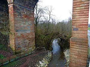
The Red Burn goes under a large railway viaduct. Soon after, it meets another stream called the Bog Stank. This meeting point is just downstream from a bridge over a path.
After joining the Bog Stank, the Red Burn flows past the dovecote and Broom Road in Abronhill. It then goes back under the Forest Road Bridge, heading towards Dunns Wood.
Water Treatment and Flood Control
The river then passes through a sewage treatment plant. In 2013, this plant was updated to clean water from the Wardpark Estate before it enters the river. Scottish Water built a system of ponds there. These ponds act like natural filters. They hold the water, clean it, and then slowly release the purified water.
This system is called a Sustainable Urban Drainage System (SUDS). It helps prevent flooding by soaking up water from sudden storms. It then releases the water slowly over time. This process also helps remove pollution, sending cleaner water back into the river. Because the area is large, six ponds were needed. This project also added a new treatment process to clean wastewater even better. This helps with the town's growth.
Further Downstream
The Walton Burn is another important stream that joins the Red Burn. It flows around the east side of Abronhill. At this point, the Red Burn forms the border between the Falkirk and North Lanarkshire councils.
The Red Burn then flows under the M80 motorway, the B816 road, and the 18th-century Castlecary Viaduct. This viaduct carries the railway tracks. This area is also close to the historic Castle Cary Castle.
After crossing the road and railway, the Red Burn flows under the Forth and Clyde Canal. The canal crosses the river using a special bridge called an aqueduct. This is near the Bonny Water.
The Red Burn then meets the smaller Bonny Water just north of the canal. From this point, the river is called the Bonny Water. It continues until it reaches the River Carron further downstream. The River Carron eventually flows into the Firth of Forth at Grangemouth.
Why is Cumbernauld Called That?
Cumbernauld is the largest town in North Lanarkshire. There are two main ideas about how the town got its name, "Comar nan Allt," which means "the confluence of the waters" in Gaelic.
The Meeting of Streams Idea
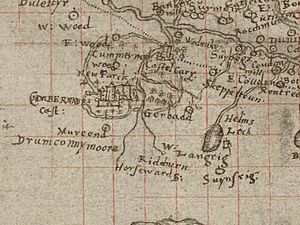
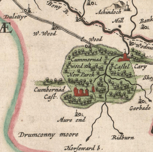
One idea is that the name refers to where the Red Burn meets the Bog Stank. This happens in the Vault Glen, close to where the old Comyn’s Castle used to be. The oldest maps of Cumbernauld show the "Rid Burn" joining three other streams. On these maps, they all seem to meet at one spot. The 1596 Pont's Map is one of the earliest to show the river. Blaeu's colored map, made in 1654, also shows this clearly.
The Watershed Idea
The other idea is that Cumbernauld's name comes from it being a Scottish watershed. A watershed is a high area of land where water flows in different directions. In this case, the Red Burn flows east towards the Firth of Forth. The Luggie Water flows west towards the River Clyde. These two rivers do not actually meet. So, Cumbernauld is like a dividing line for water flow in Scotland's Central Belt.
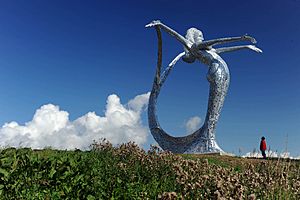
Jim Carruth, a poet, wrote a poem called "Watershed." This poem is carved into the base of Andy Scott's Arria statue, also known as The Angel of the 'Naud. This statue can be seen from the A80 road in Cumbernauld. The poem supports the idea that the town's name is about being a watershed. Hugo Millar, a local historian, also believed this theory.
Historian Peter Drummond has looked at both ideas from history and geography. What we know for sure is that the Red Burn is part of the reason Cumbernauld got its name.
Local Names from the Burn
Several places in Cumbernauld are named after the Red Burn. Three streets in the Abronhill area use the older form of the name, "Redburn," as one word. Redburn School also gets its name from the stream.
Roman History in the Area
The Antonine Wall, built by the Roman Emperor Antoninus Pius, crosses the Red Burn at Castlecary. Roman remains have been found on both sides of the river. This wall is a Unesco World Heritage site.
Over the years, the land around the Red Burn has changed a lot. This is because of the Forth and Clyde Canal, the Glasgow to Edinburgh railway, and the M80 road. Older maps show that the Roman fort of Castle Cary was east of the river. The later Castle Cary Castle was also there. There was also a Roman camp west of the river, near the modern Castlecary Hotel.
There is a story about how the Red Burn got its name. It says that Agricola's Roman soldiers were killed and their bodies were put into the river at Castlecary. The story claims this made the river run red.
Other Rivers in Cumbernauld
Cumbernauld has at least two main rivers: the Red Burn and the Luggie Water. There is also the Moss Water, which was dammed to create Broadwood Loch.
 | Leon Lynch |
 | Milton P. Webster |
 | Ferdinand Smith |


