
Cadder facts for kids
Quick facts for kids Cadder
|
|
|---|---|
 Cadder parish church erected in 1830 |
|

Cadder
|
|
| OS grid reference | NS6172 |
| Council area | |
| Country | Scotland |
| Sovereign state | United Kingdom |
| Police | Strathclyde |
| Fire | Strathclyde |
| Ambulance | Scottish |
| EU Parliament | Scotland |
| UK Parliament |
|
| Scottish Parliament |
|
Cadder (Scottish Gaelic: Coile Dobhair) is a small area in the town of Bishopbriggs, East Dunbartonshire, Scotland. It is about 7 kilometers (4.3 miles) north of Glasgow city center. Cadder is located near the River Kelvin and the Forth and Clyde Canal.
There is a golf club in the area called Cawder Golf Club. It uses an older way of saying the name, "Cawder."
Cadder's Ancient Past
Cadder was once home to a Roman fort. This fort was part of the famous Antonine Wall. The Antonine Wall was a huge barrier built by the Romans across Scotland. It helped protect the Roman Empire.
The Cadder fort was located between other Roman forts. These included Balmuildy to the west and Kirkintilloch to the east. Smaller forts, called fortlets, were also nearby.
Historians believe the Second Legion of the Roman army might have built the fort. In the 1930s, an archaeologist named John Clarke studied the remains of the fort. Another expert, Sir George Macdonald, also wrote about the discoveries there.
Sadly, the fort site was destroyed in the 1940s due to sand quarrying. One interesting item found at Cadder was an oil lamp. This lamp was likely from the fort's bath house.
Cadder also has a long history with its church. Before the Reformation, the Bishops of Glasgow owned the lands and the church. In the 18th century, there was a disagreement about who should choose the church's minister. Cadder Parish Church was built in 1830.
Cadder House was another important property in the area. It belonged to the Stirling family for many generations.
Cadder Today
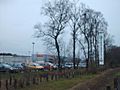
Today, Cadder is home to a large cemetery. It also has the Strathkelvin Retail Park. This is a place where you can find many different shops.
Images for kids
-
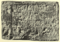
Distance slab of the Second Legion found built into Cawder House.
-
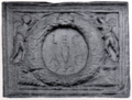
Another distance slab of the Second Legion, possibly from Auchendavy.
-
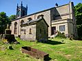
Watchhouse and iron mortsafe at Cadder Parish Church.
-
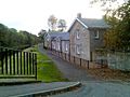
Cadder stables.
-
Strathkelvin retail park.
-
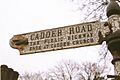
Cadder Road sign.
-
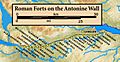
Map showing the forts and fortlets along the Antonine Wall.
-
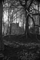
Cadder Kirk as seen from the Forth and Clyde Canal.


