
Castlehill Fort facts for kids
Quick facts for kids Castlehill Fort |
|
|---|---|

Castle Hill, East Dunbartonshire
|
|
| Founded during the reign of | Antoninus Pius |
| Place in the Roman world | |
| Province | Britannia |
| Stationed military units | |
| — Legions — | |
| 20th 6th |
|
| Location | |
| County | East Dumbartonshire |
| Country | |
Castlehill was an important Roman fort in Scotland. It was built along the Antonine Wall. This wall was a huge barrier created by the Romans. It helped them control their territory in ancient Britannia.
Where is Castlehill Fort?
The fort is in East Dunbartonshire, Scotland. It is west of Bearsden and east of Duntocher. You can find it south of the A810 Duntocher Road.
Castlehill Fort had other Roman forts nearby. Bearsden was to its east. Duntocher was to its west. There was also a smaller fortlet called Cleddans between them. Hutcheson Hill was even closer.
Today, you can mostly see a circle of beech trees. This area marks where the fort once stood. From the top of Castlehill, you can see a wide view. Many historical discoveries have been made here. It can be tricky to see the exact line of the Antonine Wall. But there are some signs to help you find it.
What Was Found at Castlehill?
Archaeologists have found exciting Roman objects at Castlehill. These finds help us learn about life in the fort.


Two special Roman stones, called distance slabs, were found here. These slabs told how much of the wall a Roman legion had built. One slab was found in 1803. It was discovered on Low Millichen Farm. This farm is now called East Millichen. It recorded that the Sixth Legion built 3666.5 paces of the wall.
Another distance slab was found in 1826. A Roman altar was also discovered in the same year. This altar was a stone used for religious offerings.
Life at the Fort
Many Roman forts along the Antonine Wall had about 500 soldiers. Larger forts, like Castlecary, could hold around 1000 soldiers. Even though soldiers were not allowed to marry, women and children likely lived nearby. There were probably large communities of civilians around the fort too. These people would have supported the soldiers and traded with them.
Images for kids
-
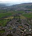
This is a view from above Bearsden. You can see the Antonine Wall's path. Castle Hill is the ring of trees in the center. The widening River Clyde and Dumbarton Rock can be seen far away.
-
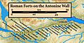
This map shows the forts and smaller fortlets along the Antonine Wall. They stretch from west to east.
.jpg)

