
Cleddans facts for kids
Quick facts for kids Cleddans |
|
|---|---|
.jpg)
Cleddans Farm from the air
|
|
| Founded during the reign of | Antoninus Pius |
| Attested by | Trial trenching |
| Place in the Roman world | |
| Province | Britannia |
| Stationed military units | |
| — Legions — | |
| 20th 6th |
|
| Location | |
| Coordinates | 55°55′12.7″N 4°23′19.3″W / 55.920194°N 4.388694°W |
| Town | Glasgow |
| Country | United Kingdom |
| Site notes | |
| Condition | Ploughed over |
| Excavation dates | 1980 (Trial trenching) |
Cleddans was once a small Roman fortlet located on the Antonine Wall in Scotland. A fortlet is like a mini-fort, smaller than a full fort. For a long time, people thought it might exist, and its presence was finally proven by digging in 1979. Roman soldiers from the 6th and 20th legions helped build both Cleddans and parts of the Antonine Wall nearby.
Contents
Finding the Cleddans Fortlet
.jpg)
Archaeologists found the Cleddans Roman fortlet in 1980. They used a method called "trial trenching," which means digging small test ditches to look for buried structures. The fortlet was found south of the main road between Duntocher and Bearsden.
Experts believed there might be a fortlet here because Hutcheson Hill was exactly halfway between two known Roman forts: Duntocher to the west and Castlehill to the east. It also had a clear view between them. Finding Cleddans helped prove that the Antonine Wall was designed to have these smaller fortlets about every Roman mile.
The fortlet itself was quite small. Inside, it measured about 18 meters (59 feet) from east to west and 17.6 meters (58 feet) from north to south. It was surrounded by a defensive wall, or "rampart," built on a stone base that was about 3.6 meters (12 feet) wide.
Life at Cleddans: Roman Times

Cleddans was built between 142 and 154 AD. This was during the rule of the Roman Emperor Antoninus Pius. Quintus Lollius Urbicus, who was the governor of Roman Britain at the time, was in charge of the building project.
Cleddans was one of many forts and fortlets built to support the Antonine Wall. A special road, called the Military Way, connected all these sites, making it easier for troops to move around. Emperor Antoninus Pius never actually visited Britain, unlike the previous emperor, Hadrian.
The Romans built the Antonine Wall further north than Hadrian's Wall because of pressure from local tribes like the Caledonians. However, Cleddans and the Antonine Wall were abandoned only eight years after they were finished. The Roman soldiers moved back to Hadrian's Wall.
Later, in 208 AD, Emperor Septimius Severus sent legions back to the wall and ordered repairs. Because of this, the wall is sometimes called the Severan Wall. But this occupation also ended a few years later, and the wall was never used by the Romans again.
Most Roman fortlets along the wall had about 500 soldiers. Larger forts, like Castlecary, could hold more. While soldiers were not allowed to marry, there is evidence that women and children also lived near these forts. It's likely that small communities of civilians grew up around places like Cleddans.
Amazing Roman Finds
Archaeologists have found several important Roman tablets at or near the Cleddans site. These tablets often tell us about the Roman legions who built parts of the wall.
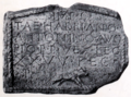
- The Running Boar Tablet: One tablet shows a running boar, which was the symbol of the 20th Legion. It was found in 1695 at Cochno House. Today, you can see it at the Hunterian Museum in Glasgow.
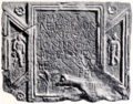
- The Braidfield Farm Tablet: Another tablet was found in 1812 at Braidfield Farm, just west of Cleddans Farm. This tablet shows two winged figures of Victory, standing on globes and holding up a rectangular inscription. On one side is the Roman god Mars, and on the other is Virtus, a goddess representing bravery. The tablet also has decorative shields. The inscription on it includes the words "Opus Valli," which means "Work of the Wall." This suggests it was the Romans' own name for their wall. This tablet is also at the Hunterian Museum.
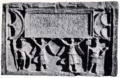
- Another Running Boar Tablet: A third tablet, found in 1865 on Hutcheson Hill, also showed a palm tree and another running boar, the symbol of the 20th Legion. Sadly, this tablet was lost in a fire in Chicago in 1871. However, the Hunterian Museum has a plaster cast made from the original. This tablet also features two naked figures of Cupid, each holding a sickle and grapes.
These three tablets contain building inscriptions from the 20th and 6th Legions, dedicated to Emperor Antoninus Pius. They date back to between 139 and 161 AD. Interestingly, no Roman coins have been found at the Cleddans site.
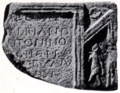
- The Fourth Tablet (RIB 3507): A well-preserved fourth tablet was discovered in March 1969 at Cleddans Farm, on the west side of Hutcheson Hill. Some people think it might belong to the Castlehill fort instead. This tablet shows images of local people who were conquered by the Romans, similar to other slabs found at Bridgeness and Westerwood. It also has symbols like a jumping boar. It's not certain who the female figure on the tablet represents; some suggest Victoria, Britannia, or Faustina the Elder.
Sir George Macdonald, a famous archaeologist, wrote about the Cleddans site in his book The Roman Wall in Scotland, first published in 1911.
Images for kids
-
RIB 2206. This is a distance slab from the Twentieth Legion Valeria Victrix. It was found towards the west of the wall and is often linked to Old Kilpatrick.
-
RIB 2198. This distance slab from the Twentieth Legion was found near Cleddans. It was unfortunately destroyed in the Great Chicago Fire.
-
RIB 2199. This distance slab is also from the Twentieth Legion Valeria Victrix. It might have been a "waster" (a piece that wasn't perfect) and doesn't have distance information.
-
RIB 2200. This distance slab from the Sixth Legion was found at Braidfield Farm, which is between Cleddans and Duntocher.


