
Stirlingshire facts for kids
Quick facts for kids
Stirlingshire
|
||
|---|---|---|
|
||
 |
||
| Country | Scotland | |
| County town | Stirling | |
| Area | ||
| • Total | 447 sq mi (1,158 km2) | |
| Ranked 21st of 34 | ||
| Chapman code |
STI
|
|

Stirlingshire (also known as the County of Stirling) is a historic area in Scotland. Its main town is Stirling. It's a place with a long and interesting past, especially known for its important battles.
Stirlingshire shares borders with several other areas. To the north is Perthshire, to the east is Clackmannanshire, and to the south-east is West Lothian. It also borders Lanarkshire to the south and Dunbartonshire to the south and south-west.
Contents
A Look Back in Time: Stirlingshire's History
Stirlingshire has been the site of many important events in Scottish history.
Key Battles and Events
- 1130: Stirling Becomes a Royal Town
In 1130, Stirling, which was a very important stronghold in the Kingdom of Scotland, was made a "royal burgh" by King David I. This meant it had special rights and was a key trading center.
- 1297: The Battle of Stirling Bridge
On September 11, 1297, Scottish forces led by Andrew Moray and William Wallace fought a big battle near Stirling. They defeated the English army at the River Forth during the First War of Scottish Independence. This was a major victory for Scotland.
- 1298: The Battle of Falkirk
Less than a year later, on July 22, 1298, William Wallace faced King Edward I of England at the Battle of Falkirk. This time, the Scottish forces were defeated.

- 1314: The Battle of Bannockburn
One of Scotland's most famous victories happened on June 24, 1314, at the Battle of Bannockburn. This battle was a turning point in the Wars of Scottish Independence. Robert the Bruce led the Scottish army to a decisive win against the English.
- 1488: The Battle of Sauchieburn
On June 11, 1488, the Battle of Sauchieburn took place near Stirling. It was a fight between King James III of Scotland and a group of Scottish nobles. The nobles were led by the king's 15-year-old son, Prince James.
- 1645: The Battle of Kilsyth
In 1645, a major battle of the Wars of the Three Kingdoms happened at Kilsyth. The Covenanter army fought against the Royalist forces.
- 1746: The Battle of Falkirk Muir
On January 17, 1746, the Battle of Falkirk Muir saw the Jacobites, led by Charles Edward Stuart, defeat a government army.
How Stirlingshire Was Governed
Stirlingshire has changed how it's governed over many years. It started as a "shire," an area managed by a sheriff, around the time of King David I (1124–1153).
.jpg)
In 1890, elected county councils were created to manage local affairs. The town of Stirling was initially separate, but the county council still met there. The first meeting was on May 22, 1890, at the County Buildings.
Over time, some of Stirlingshire's borders changed. For example, Milngavie moved to Dunbartonshire, and Alva moved to Clackmannanshire. In return, Stirlingshire gained other areas.

In 1930, the town of Stirling joined the county council's administrative area. The council moved its main offices to a building called Viewforth in 1931. This building served as the county council's headquarters until 1975.
In 1975, Stirlingshire stopped being a local government area. Its land was split into new regions and districts. Today, the area that was once Stirlingshire is part of four different council areas: East Dunbartonshire, Falkirk, North Lanarkshire, and Stirling.
Even though it's not a local government area anymore, the old boundaries of Stirlingshire are still used for some official things, like registering land.
Stirlingshire's Coat of Arms
The Stirlingshire County Council received its own coat of arms in 1890. The design celebrates the Scottish victory at the Battle of Bannockburn.
The coat of arms features a red lion, like the one on the royal arms of Scotland, on a silver cross. It also includes two "caltraps" and two spur-rowels. These symbols represent weapons used against the English cavalry during the battle.
When the county council was abolished in 1975, the coat of arms was given to the new Stirling District Council. It was given again in 1996 to the current Stirling Council, with the addition of a goshawk and a wolf as supporters.
Exploring Stirlingshire's Geography
Stirlingshire is in a very important location in Scotland. It sits on the narrow strip of land between the Firth of Forth and the Firth of Clyde. This position means it controls the main land routes from Glasgow and Edinburgh to central and northern Scotland.

The western part of Stirlingshire is not very populated. It is dominated by Loch Lomond, a large lake it shares with Dunbartonshire. This area also includes the beautiful Trossachs, which is now a national park. Ben Lomond is located here and is the highest point in Stirlingshire, standing at 974 meters (3,196 feet). Several islands in Loch Lomond, such as Inchcruin and Inchcailloch, belong to Stirlingshire.

Central Stirlingshire has the Carron Valley Reservoir and hills like the Campsie Fells and Kilsyth Hills. Larger towns like Lennoxtown and Kilsyth are found along the southern border. The eastern part of the county, east of the M80, is much flatter. This is where most of the county's population lives. The Firth of Forth here provides access to the North Sea.
Getting Around: Transport in Stirlingshire
Stirlingshire has a good transport network, especially in its eastern part where most people live.
- Motorways: The M80 runs north–south, connecting Stirling and Denny to Cumbernauld. The M9 links the eastern towns to Edinburgh. Other main roads connect different parts of the county.
- Ferries and Bridges: In the far west, ferries help people cross Loch Lomond. In the far east, the Kincardine Bridge connects Stirlingshire to Fife and Clackmannanshire.
- Railways: Only the eastern part of the county has train connections. These railways link towns to each other and to major cities like Edinburgh, Glasgow, and Perth.
Local Places: Towns, Villages, and Burghs
Stirlingshire is made up of many towns and villages. Historically, some of these were known as "burghs," which were towns with special legal rights.
Burghs of Stirlingshire

- The Royal Burgh of Stirling (from the 12th century)
- The Burgh of Bridge of Allan
- The Burgh of Denny and Dunipace
- The Burgh of Falkirk
- The Burgh of Grangemouth
- The Burgh of Kilsyth
Until 1930, Stirling was managed separately from the county council. After 1930, Stirling and Falkirk became "large burghs," meaning they had more power to manage their own local services.
Civil Parishes

Civil parishes are older divisions of land that are still used today for some statistics, like counting populations. This helps compare how populations have changed over a long time.
Some of the civil parishes in Stirlingshire include:
Towns and Villages Today
Here are some of the towns and villages you can find in Stirlingshire:
- Airth
- Allandale
- Arnprior
- Avonbridge
- Bainsford
- Balfron
- Balmaha
- Banknock
- Bannockburn
- Banton
- Blairlogie
- Blanefield
- Bonnybridge
- Bridge of Allan
- Brightons
- Buchlyvie
- California
- Cambusbarron
- Camelon
- Carron
- Carronshore
- Castlecary
- Cowie
- Croftamie
- Denny
- Dennyloanhead
- Drymen
- Dunipace
- Dunmore
- Falkirk
- Fallin
- Fintry
- Gargunnock
- Gartness
- Glen Village
- Grangemouth
- Haggs
- Inversnaid
- Killearn
- Kilsyth
- Kippen
- Larbert
- Laurieston
- Lennoxtown
- Limerigg
- Maddiston
- Milngavie (transferred to Dunbartonshire in 1891)
- Plean
- Polmont
- Queenzieburn
- Raploch
- Redding
- Rowardennan
- Shieldhill
- Skinflats
- Slamannan
- South Alloa
- Stirling
- St Ninians
- Standburn
- Stenhousemuir
- Strathblane
- Throsk
- Torrance
- Torwood
- Wallacestone
- Westquarter
- Whitecross
People from Stirlingshire
- Michelle Watt, a television host, writer, and interior designer.
Images for kids
-
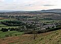
Strathblane in south-west Stirlingshire
-
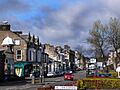
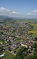
Bridge of Allan in north-east Stirlingshire
-
Stirling, the county town
-
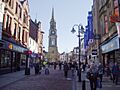
Falkirk town centre
-
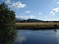
Wallace Monument from Kildean Market
-
Causewayhead area of Stirling from the Wallace Monument


