
Clackmannanshire facts for kids
Quick facts for kids
Clackmannanshire
Siorrachd Chlach Mhanann |
|||
|---|---|---|---|
 |
|||
|
|||
| Sovereign state | United Kingdom | ||
| Country | Scotland | ||
| Lieutenancy area | Clackmannanshire | ||
| Admin HQ | Alloa (since 1822) Clackmannan (until 1822) |
||
| Government | |||
| • Body | Clackmannanshire Council | ||
| Area | |||
| • Total | 61.4 sq mi (159.0 km2) | ||
| Area rank | Ranked 30th | ||
| Population
(2020)
|
|||
| • Total | 51,400 | ||
| • Rank | Ranked 29th | ||
| • Density | 837.3/sq mi (323.3/km2) | ||
| ONS code | S12000005 | ||
| ISO 3166 code | GB-CLK | ||

Clackmannanshire is a special area in Scotland. It is known as a historic county and also a modern council area. It borders other areas like Stirling, Fife, and Perth and Kinross.
The name "Clackmannanshire" comes from three different languages. "Clach" means "Stone" in Scottish Gaelic. "Mannan" comes from an old Celtic tribe called the Manaw. The last part, "shire," is an English word for a county or region.
Clackmannanshire is the smallest historic county in Britain. Because of its small size, it is often called "The Wee County." When people write its name, they sometimes shorten it to "Clacks."
Contents
- Discovering Clackmannanshire's Past
- Understanding Clackmannanshire's Government
- Council Elections and Wards
- Community Councils
- International Connections
- Clackmannanshire's Coat of Arms
- Exploring Clackmannanshire's Geography
- Clackmannanshire's Economy
- Getting Around Clackmannanshire
- Towns and Villages in Clackmannanshire
- Places to Visit in Clackmannanshire
- See also
Discovering Clackmannanshire's Past
Clackmannanshire gets its name from its original main town, Clackmannan. This town was named after a special stone linked to an ancient god called Manau or Mannan. Today, this stone sits on a bigger stone next to the old Clackmannan Tolbooth tower.

In the past, Clackmannanshire was famous for its weaving mills. These mills used power from the local streams, called "Hillfoots burns." Other important jobs included brewing beer, making glass, mining, and building ships.
Today, Clackmannanshire uses its good location and transport links to attract new businesses. Service industries and tourism are now very important here.
The motto for Clackmannanshire is "Look Aboot Ye." This means "Look around you" in Scots. In 2007, the area also started using the slogan "More Than You Imagine."
How Clackmannanshire Was Governed
Clackmannanshire became a "shire" (an area controlled by a sheriff) a very long time ago. It was definitely a shire by the year 1305. Some people think it might have existed even earlier, in the 1200s.

The main town for the county was first Clackmannan. A building called a tolbooth was built there in 1592. This building was used as the sheriff court for the county.
In 1822, the sheriff court and meeting place moved to Alloa. Alloa had grown to be a much more important town. The County Buildings were built in Alloa in 1865. This new building served as the courthouse and meeting place.

Later, in 1890, elected county councils were created. These councils took over most of the jobs from the older administrative bodies. Clackmannanshire County Council met for the first time on May 22, 1890, at the County Buildings in Alloa. This building was their main office until 1975.
In 1975, the county councils were changed. Clackmannanshire became part of a larger area called the Central region. A new "Clackmannan district" was created. This district covered the old county area plus a part of Perthshire called Muckhart.
Then, in 1996, there were more changes to local government. The regions and districts were replaced with new "council areas." These new council areas handled all local government services. The Clackmannan district became one of these new council areas. It was renamed "Clackmannanshire" before it officially started on April 1, 1996.
Understanding Clackmannanshire's Government
| Clackmannanshire Council Comhairle Siorrachd Chlach Mhanann |
|
|---|---|
| Leadership | |
|
Ellen Forson,
SNP Since 12 Apr 2018 |
|
|
Nikki Bridle
Since July 2018 |
|
| Structure | |
| Seats | 18 councillors |
|
Results of the 2022 election:
 |
|
|
9 / 18
|
|
|
5 / 18
|
|
|
3 / 18
|
|
|
1 / 18
|
|
| Elections | |
| Single transferable vote | |
|
Last election
|
6 May 2022 |
|
Next election
|
2027 |
| Meeting place | |
 |
|
| Kilncraigs, Greenside Street, Alloa, FK10 1EB | |
The Clackmannanshire Council is in charge of local services. These services include schools, roads, and waste collection. The council has 18 members called councillors. They are elected by the people living in Clackmannanshire.
Leaders of the Council
The council has a leader who helps guide its work. Here are the leaders since 1996:
| Councillor | Party | From | To | |
|---|---|---|---|---|
| Teresa McNally | Labour | 1 Apr 1996 | Feb 1998 | |
| Jim Watson | Labour | Feb 1998 | May 1999 | |
| Keith Brown | SNP | May 1999 | May 2003 | |
| Margaret Paterson | Labour | May 2003 | May 2007 | |
| Janet Cadenhead | Labour | 24 May 2007 | 23 Sep 2010 | |
| Sam Ovens | Labour | 23 Sep 2010 | 6 Jan 2012 | |
| Gary Womersley | SNP | 6 Jan 2012 | 3 Nov 2014 | |
| Les Sharp | SNP | 3 Nov 2014 | 12 Apr 2018 | |
| Ellen Forson | SNP | 12 Apr 2018 | ||
Where the Council Meets
Since 2014, the council's main office has been at Kilncraigs in Alloa. This building was originally a factory and warehouse for knitting yarn. It was built in 1904.
Before 2014, the council met at Greenfield House. This building was first a house built in 1894. It became the town council's office in 1952.
Council Elections and Wards
Elections for the Clackmannanshire Council happen every five years. People vote using a system called "single transferable vote." This system helps make sure that more voices are heard.
Election Results Over Time
Here are the results from past elections:
| Year | Seats | SNP | Labour | Conservative | Green | Liberal Democrats | Independent / Other | Notes |
|---|---|---|---|---|---|---|---|---|
| 1995 | 12 | 3 | 8 | 1 | 0 | 0 | 0 | |
| 1999 | 18 | 9 | 8 | 1 | 0 | 0 | 0 | New ward boundaries. |
| 2003 | 18 | 6 | 10 | 1 | 0 | 0 | 1 | |
| 2007 | 18 | 7 | 8 | 1 | 0 | 1 | 1 | New ward boundaries. |
| 2012 | 18 | 8 | 8 | 1 | 0 | 0 | 1 | |
| 2017 | 18 | 8 | 5 | 5 | 0 | 0 | 0 | New ward boundaries. |
| 2022 | 18 | 9 | 5 | 3 | 1 | 0 | 0 |
Council Wards and Areas
Since 2007, Clackmannanshire has been split into five areas called "wards." Each ward elects several councillors.
| Ward number |
Location | Ward name | Settlements | Seats | Population (2019) |
|---|---|---|---|---|---|
| 1 | Clackmannanshire West | Menstrie, Glenochil, Tullibody, Cambus | 4 | 12,606 | |
| 2 | Clackmannanshire North | Alva, Tillicoultry, Coalsnaughton | 4 | 10,731 | |
| 3 | Clackmannanshire Central | Sauchie, Fishcross, Alloa | 3 | 7,936 | |
| 4 | Clackmannanshire South | Alloa | 4 | 11,618 | |
| 5 | Clackmannanshire East | Clackmannan, Dollar, Muckhart, Kennet, Forestmill, Solsgirth, Alloa | 3 | 8,649 | |
| Total | 18 | 51,540 |


Community Councils
Clackmannanshire has nine community council areas. Most of these areas have their own community councils. These councils help local people have a say in what happens in their area.
International Connections
Since 2006, Clackmannanshire has been "twinned" with two towns in other countries. These are Vendargues in southern France and Espartinas in Andalusia, Spain. Town twinning helps build friendships and understanding between different places.
Clackmannanshire's Coat of Arms
Clackmannanshire has its own special design called a coat of arms. It features a red X-shape on a gold background. This part comes from the design of the Clan Bruce.
There's a story that Robert Bruce once lost his gloves while visiting the county. When he asked where they were, he was told to "look aboot ye" (look around you). This is why "Look Aboot Ye" is the county's motto.
The green top part of the shield shows the area's farming. The black and white stripe comes from the Clan Erskine. The chief of this clan, the Earl of Mar, lives at Alloa Tower.
Exploring Clackmannanshire's Geography

Clackmannanshire is the smallest council area in mainland Scotland by population. About half of its people live in the main town, Alloa.
The Ochil Hills cover the northern part of the county. Ben Cleuch is the highest point in Clackmannanshire. It is about 721 meters (2,365 feet) tall.

South of the hills is a flat area called Strathdevon. The River Devon flows through this area and joins the River Forth. Another river, the Black Devon, flows past Clackmannan town and also joins the Forth near Alloa.
In the middle of the county, you can find Gartmorn Dam County Park. There are also small forests in the southeast. The River Forth forms the southern border of Clackmannanshire. It has two small islands called Tullibody Inch and Alloa Inch.
Clackmannanshire's Economy

The main jobs in Clackmannanshire involve agriculture (farming) and brewing (making drinks like beer). In the past, coal mining was also very important.
In 2006, plans were approved to develop the Docks area of Alloa. This area had been in decline since the 1960s. There is also a large glass works in Alloa.
Getting Around Clackmannanshire
The Alloa railway station reopened in May 2008. Before that, the county did not have any active train stations. A new railway line was built to connect Kincardine and Stirling. This reconnected Alloa to the national train network for the first time since 1968.
Regular passenger trains run between Alloa, Stirling, and on to Glasgow and Edinburgh. The line to Kincardine is mostly used for freight trains.
The Clackmannanshire Bridge is a new road bridge over the River Forth. It opened in 2008. This bridge helps reduce traffic on the older Kincardine Bridge.
Major roads in the area include the A91, which goes through the Hillfoots Villages. The A907 passes through Alloa and Clackmannan.
Towns and Villages in Clackmannanshire

Here are some of the biggest towns and villages in Clackmannanshire:
| Settlement | Population (2020) |
|---|---|
| Alloa | 14440 |
| Tullibody | 8490 |
| Sauchie | 6310 |
| Alva | 4630 |
| Tillicoultry | 4620 |
| Clackmannan | 3260 |
| Menstrie | 2870 |
| Dollar | 2840 |
| Coalsnaughton | 1290 |
| Glenochil | 750 |
Other smaller places include:
- Cambus
- Devonside
- Fishcross
- Forestmill
- Inglewood
- Kennet
- Muckhart
- Solsgirth
Places to Visit in Clackmannanshire
There are many interesting places to see in Clackmannanshire:
- Alloa Tower
- Auchinbaird Windmill
- Ben Cleuch
- Broomhall Castle
- Brucefield House
- Castle Campbell
- Clackmannan House
- Harviestoun Brewery
- Gartmorn Dam
- Gean House
- Menstrie Castle
- Tullibody Old Kirk
-
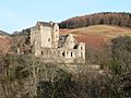
Castle Campbell, a medieval castle situated above the town of Dollar
-
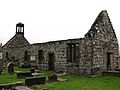
Tullibody Old Kirk, a ruined 12th-century church in Tullibody


See also
 In Spanish: Clackmannanshire para niños
