
Ochil Hills facts for kids


The Ochil Hills (which in Scottish Gaelic is Scottish Gaelic: Monadh Ochail) are a range of hills in Scotland. They are located north of the Forth valley. Towns like Stirling, Alloa, Kinross, Auchterarder, and Perth surround them.
Only a few main roads cross these hills. These roads go through Glen Devon/Glen Eagles and Glenfarg. The M90 now mostly replaces the Glenfarg road for long-distance travel.
These hills were formed from ancient Devonian lava. Their shape today is mainly because of the Ochil Fault. This fault makes the southern side of the hills a very steep slope, like a cliff. The top of the hills is wavy, without one really tall peak. The highest point is Ben Cleuch, which is 721 meters (2,365 feet) tall. Rivers flowing south have carved deep, narrow valleys. These include Dollar Glen, Silver Glen, and Alva Glen. Sometimes, you need wooden walkways to get through them.
The exact size of the Ochil Hills isn't always clear. Some people think they also include the hills in northern Fife.
Historically, the hills were very important. They helped make Stirling a key gateway to the Highlands. This was because Stirling was the lowest point where you could cross the River Forth. The hills also acted as a natural border with Fife. Castle Campbell was built at the top of Dollar Glen in the late 1400s. It was a clear sign of the Campbell family's power in the area. The Battle of Sheriffmuir in 1715 happened on the northern slopes of the hills. This was during a Jacobite uprising.
During the early Industrial Revolution, towns like Tillicoultry, Alva, and Menstrie grew up here. These are known as the Hillfoots Villages. They used the water power from the hills to run their mills. Some of these old mills are now museums you can visit.
Blairdenon Hill was a site for one of the "Beacons of Dissent." This was during the G8 protests in July 2005.
Contents
What's in a Name? The Ochil Hills' Meaning
The name Ochil was first written as Okhel in the 1200s. It comes from the ancient Pictish language. The name might mean "a ridge." It's less likely that it means "high" or "tall," even though the Welsh word uchel means that.
How the Ochil Hills Were Formed: A Look at Geology
The Ochil Hills are made of a thick layer of volcanic rocks. These rocks are from the Devonian period, which was millions of years ago. They rise up from older rocks to the north. To the south, they end sharply because of the big Ochil Fault. This fault caused the land to drop down.
The main rocks are from the Ochil Volcanic Formation. These include basaltic andesite and trachyandesite lavas. They erupted during the Early Devonian time. Some lower parts of the northern hills, near Blackford and Auchterarder, are made of volcanic rock mixed with pebbles. Many thin rock layers, called dykes, cut through the hills. These are made of micridiorite and are from the Silurian/Devonian period. Other types of volcanic rocks are also found.
The whole area has many faults, which are cracks in the Earth's crust. Some valleys, like Alva Glen and Glen Sherup, formed along these fault lines. Much of the lower land around the hills is covered by till, which is rock and soil left by glaciers. On the flat tops of the hills, especially in the west, you can find layers of peat.
Ancient Stories: Pictish Folklore of the Ochils
Old stories and historical records suggest that the Picts once lived in the Ochil Hills. Or at least, they had some settlements there. Castle Craig was an old fort above the village of Mill Glen. It was destroyed by quarrying for stone. In 1883, a local historian named William Gibson said it was "a round Pictish fortress." He noted that you could still see its remains clearly. Old tales also say that some stones from Castle Craig were used to build Stirling Castle. That's about 12.5 kilometers (7.75 miles) to the west.
Another interesting story from the Ochil Hills is about Katie Thirsty's Well. This is a special well with many myths around it. Historians have tried to find out who "Katie Thirsty" was. But a Pictish researcher, Ronald Henderson, believes the name comes from two sources. He thinks it's a mix of St. Katherine of Alexandria ("Katie") and the Pictish King, Drust or Drustan ("Thirsty"). He also says that the large cliffs of Dumyat, less than a mile east, are thought to be the last Pictish stronghold.
Powering Up: Wind Farms in the Ochil Hills
In June 2006, a plan for an 18-turbine wind farm was approved. It was built at Green Knowes, south of Auchterarder. This is north of Glendevon, about 400 meters (1,312 feet) north of the Ben Thrush summit.
Another wind farm was approved in early 2007. This one has thirteen 102-meter (335-foot) turbines on Burnfoot Hill. This hill is north of Tillicoultry and Ben Cleuch. It's also south of the Upper Glendevon Reservoir. This wind farm has fifteen 2-megawatt and six 2.05-megawatt turbines. Their highest point is 100 meters (328 feet) tall. EDF Renewables owns and runs this wind farm. They help the Ochils Mountain Rescue Team with money. They give £5,000 every year until 2039 from the Burnfoot Hill Community Fund.
Helping Out: The Ochils Mountain Rescue Team
The Ochil Hills are home to the Ochils Mountain Rescue Team. This team was started in 1971. It's a local part of the Mountain Rescue Committee of Scotland. The team has 35 volunteer mountaineers. They have special training to "find and help people who are in trouble outdoors."
High Points: Peaks in the Ochil Hills


Here are some of the highest peaks in the Ochil Hills:
- Ben Cleuch (721 m)
- Ben Buck (679 m)
- Andrew Gannel Hill (670 m)
- King's Seat Hill (648 m)
- Tarmangie Hill (645 m)
- Whitewisp Hill (643 m)
- Whum Hill (640 m)
- The Law (638 m)
- Blairdenon Hill (631 m)
- Ben Ever (622 m)
- Grodwell Hill (622 m)
- Greenforet Hill (613 m)
- Innerdownie (611 m)
- Cairnmorris Hill (606 m)
- Skythorn Hill (601 m)
- Mickle Corum (594 m)
- Bentie Knowe (578 m)
- Scad Hill (586 m)
- Craighorn (583 m)
- Burnfoot Hill (583 m)
- Bengengie Hill (565 m)
- Middle Hill (556 m)
- Colsnaur Hill (553 m)
- Core Hill (543 m)
- Mid Cairn (542 m)
- Sauchanwood Hill (541 m)
- Burnfoot Hill (526 m)
- Wood Hill (525 m)
- Saddle Hill (522 m)
- Big Hunt Hill (520 m)
- Little Corum (520 m)
- Ben Shee (516 m)
- Craig Leith (513 m)
- Kidlau Hill (510 m)
- Wether Hill (503 m)
- Bald Hill (500 m)
- Innerdouny Hill (497 m)
- Elistoun Hill (497 m)
- Craigentaggert Hill (493 m)
- Scad Law (488 m)
- Steele's Knowe (485 m)
- John's Hill (483 m)
- Sim's Hill (483 m)
- Glentye Hill (481 m)
- Green Law (481 m)
- Berry Hill (East) (480 m)
- Mellock Hill (479 m)
- Eastbow Hill (476 m)
- Corb Law (475 m)
- East Craig (473 m)
- Green Knowes (473 m)
- Commonedge Hill (468 m)
- Glenquey Hill (466m)
- Carlownie Hill (465m)
- Rowan Tree Craig ( 460m)
- Ben Thrush (456 m)
- Lendrick Hill (456 m)
- Big Torry (452 m)
- The Nebit (449 m)
- Long Craig (448 m)
- Black Creich Hill (443 m)
- Little Law (443m)
- Hillfoot Hill (442 m)
- Seamab Hill (439 m)
- White Creich Hill (436 m)
- Little Hunt Hill (431 m)
- The Seat (429 m)
- Kinpauch Hill (426 m)
- Lamb Hill (422 m)
- Brown Hill (419 m)
- Dumyat (418 m)
- Loss Hill (417 m)
- Beld Hill (412 m)
- Common Hill (412 m)
- Craig Rossie (410 m)
- Carmodle (408 m)
- Cock Law (408 m)
- Burnt Hill (405 m)
- The Law (404 m)
- Muckle Law Hill (400m)
- Castleton Hill (396 m)
- Tam Beth (391 m)
- Cleuch Hill (390 m)
- Hillkitty (390m)
- Myreton Hill (387 m)
- Castle Law (374 m)
- Knock Wood (367 m)
- Dochrie Hill (366 m)
- Down Hill (361 m)
- Black Hill (East) (357 m)
- Bank Hill (346 m)
- Cloon (346 m)
- Black Maller (336 m)
- Tillyrie Hill (332 m)
- Braughty Hill (325 m)
- Rossie Law (324 m)
- Culteuchar Hill (313 m)
- Whitehill Head (307 m)
- Arlick Hill (307 m)
- Coul Hill (306 m)
- Montalt Hill (300 m)
- Glenearn Hill (300m)
- Norman's Law (285 m)
- Cairnie Hill (228 m)
- Black Hill (West) (226 m)
- Mount Hill (221 m)
- Lucklawhill (190 m)
- White Hill (160 m)
Images for kids
-
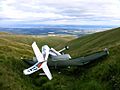
A downed Cessna 152, lying between Andrew Gannel Hill and The Law, in 2006. The pilot was not injured in the crash.

