
Dumyat facts for kids
Quick facts for kids Dumyat |
|
|---|---|
| Dùn Mhèad | |

view of the south elevation of the Dumyat.
|
|
| Highest point | |
| Elevation | 418 m (1,371 ft) |
| Prominence | 190 m (620 ft) |
| Parent peak | West Lomond |
| Listing | Marilyn |
| Naming | |
| English translation | Hill fort of the Maeatae |
| Language of name | Brythonic |
| Geography | |
|
Lua error in Module:Location_map at line 420: attempt to index field 'wikibase' (a nil value).
|
|
| Parent range | Ochil Hills |
| OS grid | NS835977 |
| Topo map | OS Landranger 57 |
Dumyat or Dunmyat is a cool hill in central Scotland. It's part of the Ochil Hills. Its name, Dùn Mhèad in Scottish Gaelic, means "hill fort of the Maeatae." The Maeatae were an ancient group of people.
Even though Dumyat is not super tall (it's 418 meters high), it has a special shape. This shape makes it a famous part of the scenery around Stirling. You often see it on postcards! Many people love to climb Dumyat. It's close to historic Stirling and the Wallace Monument. This makes it a popular spot for visitors.
Contents
Exploring Dumyat's Summits
Dumyat actually has two main tops. One is called Castle Law, on the west side. The other is Dumyat proper, on the east.
Castle Law's Ancient Fort
At the very top of Castle Law, you can still see old ruins. These are the remains of an ancient hill fort. The Maeatae people lived here a very long time ago. This fort is now a protected historical site.
Climbing Dumyat
There are a few ways to climb Dumyat. Some routes are easy, while others are more challenging.
Popular Climbing Paths
One popular way to reach the top used to be through a deep channel. This channel goes straight up the southern side of the hill. It was formed by natural changes in the rocks. This path is not too hard for most people.
There are also other channels, called gullies. Some are tricky and only for experienced climbers. For example, Raeburn's Gulley is quite dangerous. But Siart Gulley is okay for average climbers if they are careful. Other gullies are even easier to climb.
Easier Routes to the Top
Today, many people drive to Sheriffmuir and park there. From Sheriffmuir, a longer but gentler path leads to the summit. This path goes slightly north of Castle Law's top.
Another gentle way to climb is from the east, through Menstrie Glen. This path starts easy but gets steeper as you get closer to the top. It's a good climb for those who like a bit of a challenge.
Life and History on the Hill
Dumyat's open land is mostly used for sheep farming. You can spot several old sheep pens on the hillsides. There are also ruins of an old stone house where a shepherd once lived.
Mining History
In the past, people mined for copper and barytes on Dumyat. These mines were small and are now closed.
Finding Minerals
The rocky slopes of Castle Law are a good place to find agates. These are colorful stones. Sometimes, you might even find other cool crystals. These include smoky quartz and citrine. You can also find common minerals like quartz, calcite, and barytes. Two types of copper ore, malachite and azurite, are also found here.
Summit Features
When you reach the top of Dumyat, you'll find a few interesting things:
- A memorial dedicated to the Argyll and Sutherland Highlanders. This was a famous army regiment.
- A special bench that remembers Mr. Michael Simpson. He was a much-loved member of the Open University.
- A trig point. This is a marker used for surveying and mapping.
- A unique cairn (a pile of stones) with a beacon on top. People fill this beacon with stones, each representing a wish they've made.
The beacon on Dumyat was first lit in 1977. This was for the Queen's Silver Jubilee celebration. The Menstrie Scout Group carried it up the hill and set it up. It was part of a chain of beacons lit across the UK for the event.

Images for kids
-
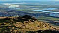
View from Dumyat looking south-east towards Grangemouth Refinery's cooling towers and the River Forth, December 2013
.jpg)
