Ochil Fault facts for kids
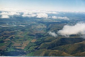
The Ochil Fault is a very old and important crack in the Earth's crust. It marks the southern edge of the Ochil Hills in Scotland. Think of it like a giant line where two huge blocks of land meet. This fault has shaped the landscape of the area for millions of years.
Contents
How the Ochil Fault Formed
The land north of the fault is made of ancient lava and ash from volcanoes. These rocks formed during the Devonian period, which was about 419 to 359 million years ago. These layers of rock gently slope downwards towards the north. Later, more rocks called Old Red Sandstone formed on top of them.
Scientists believe the volcanoes that made these rocks were actually south of where the fault is today. These old volcanoes are now buried deep under younger rocks. These younger rocks include coal layers from the Carboniferous period, which was about 359 to 299 million years ago. These coal layers are found under the flat, low-lying lands south of the fault.
Deep Buried Rocks
To understand how deep these rocks are, think about Dumyat hill. Dumyat is 418 metres tall and is at the western end of the Ochil Hills. About 2 kilometres south of the fault, there was a coal mine called Manor Powis. This mine was about the same depth as Dumyat's height, even though the land above it was almost at sea level! Miners were digging for coal from the Carboniferous rocks, which were hundreds of metres above the older Devonian rocks.
The Ochil Fault started moving a long time ago, at the very beginning of the Carboniferous period. This movement caused the land to sink in some places. This created swampy areas where plants grew, which eventually turned into coal. The land would sink, then sand or silt would cover the swamps, forming sandstone or shale. This happened many times.
Massive Land Movement
The biggest movement of the fault happened near the town of Alva. Here, the land south of the fault moved downwards by more than 5 kilometres! This is why the deepest coal layers are found in this area. However, these very deep coal deposits have not been mined much, probably because they are so far down.
Minerals and Earthquakes
The area where the land moved down the most is near a place called the Silver Glen. This part of the Ochil Hills has many valuable minerals, like silver and cobalt. These minerals likely came from hot, watery solutions that moved up through small cracks in the rocks. This happened during the Tertiary period, much later than the coal formed.
Fault Activity Today
The Ochil Fault has continued to be active throughout Earth's history. Some later movements allowed molten rock to push up through the fault. This created different types of hard rocks like diorite and quartz-dolerite in various spots along the fault line.
Today, the fault still moves, but these movements are very small. Sometimes, these tiny movements can cause small earthquakes. People in villages like Menstrie and the town of Tillicoultry might feel them. However, sometimes what feels like an earthquake in Tillicoultry could also be the ground sinking from old, collapsed coal mine tunnels underneath the town.
Seeing the Ochil Fault
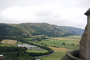
The Ochil Fault is one of the best examples in Britain of a fault line that forms a steep slope, called a scarp. You can get a great view of it from places like the Wallace Monument near Stirling. From there, you can really see how this ancient crack has shaped the landscape.
 | Misty Copeland |
 | Raven Wilkinson |
 | Debra Austin |
 | Aesha Ash |


