
Loch Lomond and The Trossachs National Park facts for kids
Quick facts for kids Loch Lomond and The Trossachs National Park |
|
|---|---|
|
IUCN Category V (Protected Landscape/Seascape)
|
|

Looking eastwards along Loch Katrine
|
|
 |
|
| Location | United Kingdom (Scotland) |
| Area | 1,865 km2 (720 sq mi) |
| Established | 2002 |
| Governing body | National park authority |
| Website | Official Website: https://www.lochlomond-trossachs.org |
Loch Lomond and The Trossachs National Park (Scottish Gaelic: Pàirc Nàiseanta Loch Laomainn is nan Tròisichean) is a special protected area in Scotland. It is one of two national parks in Scotland. This park is famous for its beautiful Loch Lomond and the many hills and valleys of the Trossachs.
The Scottish Parliament created this park in 2002. It was the first national park in Scotland. The park covers a large part of the southern Highlands. It is north of the big city of Glasgow.
This park is the fourth-largest national park in the British Isles. It covers about 1,865 km2 (720 sq mi) of land. The park has 21 Munros, which are mountains over 3,000 feet tall. Some famous ones include Ben Lomond and Ben More. It also has 20 Corbetts, which are slightly smaller mountains.
The park sits on the Highland Boundary Fault. This is a natural line that divides the park into two different areas: lowland and highland. You can see this change clearly at Loch Lomond. To the south, you'll find green fields. To the north, you'll see tall mountains.
Loch Lomond and The Trossachs National Park is close to many people in Scotland. Because of this, it has always been a popular place for visitors. People come to see the amazing scenery and wildlife. They also enjoy walking, climbing, water sports, and other outdoor activities. In 2017, about 2.9 million people visited the park.
Contents
Exploring the Park's Geography

The national park covers a big part of the southern Highlands. It is located north of Glasgow. The park is divided into four main areas: Breadalbane, Loch Lomond, The Trossachs, and Cowal.
Loch Lomond: Britain's Largest Lake
The park is centered around Loch Lomond. This is the largest lake in Great Britain by its surface area. It covers about 71 km2 (27.5 sq mi). The loch has many islands, including Inchmurrin. Inchmurrin is the biggest freshwater island in the British Isles.
Loch Lomond is a very popular place for fun activities. It is surrounded by hills, like Ben Lomond. Ben Lomond is 974 metres (3,196 ft) tall and is the most southerly Munro in Scotland. Many people think Loch Lomond is one of Britain's greatest natural wonders.
The Trossachs: Wooded Hills and Lochs
The Trossachs are an area of wooded hills, valleys, and lochs. They are located to the east of Loch Lomond. This area has been a popular spot for tourists for a long time. It's easy to reach from big cities like Glasgow and Stirling.
The Trossachs are great for walkers, cyclists, and tourists. The wooded hills and lochs look like a small version of the Scottish Highlands. These woodlands are also very important homes for many different animals and plants. A large part of the Trossachs is protected as the "Great Trossachs Forest" national nature reserve.
Breadalbane: Northern Mountains
Breadalbane is the northern part of the park. It includes villages like Crianlarich and Tyndrum. This area has steep hills and mountains from the southern Highlands. Ben More, the highest mountain in the national park, is found here.
Cowal: Western Peninsula
The westernmost part of the park is the eastern side of the Cowal peninsula. Loch Long separates it from the rest of the park. Much of Cowal is covered by the Argyll Forest Park. The Arrochar Alps, which are popular for hillwalking, are at the northern edge of Cowal.
Getting Around the Park
Several main roads and a railway line go through the park. The A82 road follows the western shore of Loch Lomond. The A85 road passes through the Breadalbane area. The West Highland Line railway also runs through parts of the park.
Why Was the National Park Created?
Scotland does not have many truly wild areas. Human activities over thousands of years have changed the landscape. Farming, cutting down trees, and grazing by sheep and deer have all shaped the land.
However, people still wanted to protect Scotland's wild and remote places. They also wanted to encourage public access. After the Second World War, a group suggested creating national parks in Scotland. Loch Lomond and The Trossachs was one of the areas they suggested.
In 2000, the Scottish Parliament passed a law to create national parks. Loch Lomond and The Trossachs National Park was officially opened on July 1, 2002. Its main goal is to protect the environment and allow people to enjoy these special places.
Wildlife and Nature in the Park

The national park is home to many different animals and plants. Over 200 types of birds and more than 25% of all plant species in Britain have been found here.
Animals You Might See
You can find many animals linked with the Scottish Highlands in the park. These include the capercaillie (a large bird), red deer, red squirrel, Scottish wildcat, and golden eagle. You might also spot peregrine falcons, black grouse, buzzards, and ospreys.
Beavers have also returned to the park. They have been seen building dams on Loch Achray. A group of wallabies has even lived on Inchconnachan, an island in Loch Lomond, since 1940!
Habitats and Plants
The park has many different types of natural areas. About 30% of the park is covered in woodland. This includes native woodlands like Atlantic oakwoods and Caledonian pinewoods. Higher up, you'll find important upland habitats like heathland and blanket bog.
The park also has 22 large lochs and 50 rivers. These waters are home to fish like salmon, trout, and Arctic charr.
Coastal Areas and Marine Life
The park also includes about 63 kilometres (39 mi) of coastline. This is around three sea lochs: Loch Long, Loch Goil, and the Holy Loch. These coastal areas have rocky shores, cliffs, and salt marshes. They are rich in small sea creatures and support many waders and seabirds. You might even see harbour seals and porpoises further out in the water.
Protected Areas within the Park
The national park is a highly protected area. There are 67 sites within the park that have special conservation status. These include 8 Special Areas of Conservation (SAC) and 2 Special Protection Areas (SPA). These are places where nature is especially important and needs extra protection.
Two of Scotland's national scenic areas are completely inside the park. These are the Loch Lomond NSA and the Trossachs NSA. There are also two forest parks and two national nature reserves here.
Fun Things to Do in the Park

The area has always been popular with tourists. The Trossachs were one of the first places in Scotland to become a well-known tourist spot. This is because of its beautiful scenery, which looks like a mini-Highlands.
In 2017, about 2.9 million people visited the park. Most of these were day trips. Popular beauty spots include the Falls of Dochart and the viewpoint at the Rest and be thankful. There's also a visitor centre in Balloch called Loch Lomond Shores. It has an aquarium, shops, and restaurants.
Water Sports and Boat Trips
Loch Lomond is one of Scotland's best places for boating and water sports. Visitors can enjoy kayaking, Canadian canoeing, paddle boarding, wake boarding, and water skiing. To keep the loch safe and protect nature, some areas have a slow speed limit of 11 km/h (5.9 kn; 6.8 mph). Other parts of the loch allow speeds up to 90 km/h (49 kn; 56 mph).
You can take boat trips on Loch Lomond from places like Tarbet and Luss. On Loch Katrine in the Trossachs, you can ride the old steamship SS Sir Walter Scott, which was launched in 1899!
Walking and Hiking Trails
The park is very popular for walking. There are easy family walks and challenging hillwalking routes up the highest mountains. Famous mountains to climb include Ben Lomond and The Cobbler.
The West Highland Way, Scotland's first long-distance walking path, goes through the park. It follows the eastern shore of Loch Lomond. Five other long-distance trails also pass through the park, like the Loch Lomond and Cowal Way.
Camping and Access Rules
In Scotland, people generally have a right to responsible access to land and water. This means you can walk, camp, swim, and canoe in the park. However, in 2017, the national park authority made new rules about camping. This was because of problems like litter and bad behavior from some campers.
Now, camping is restricted in many areas, especially around the main lochs. You need to camp at special designated sites and buy a permit between March and October.
How the Park is Managed

The Loch Lomond and The Trossachs National Park is managed by a special group called the national park authority. This group works for the Scottish Government.
National parks in Scotland have four main goals:
- To protect and improve the natural and cultural heritage of the area.
- To encourage using the park's natural resources in a way that doesn't harm them.
- To help people understand and enjoy the park's special qualities.
- To help the communities in the park grow in a way that lasts.
The park authority is in charge of planning decisions in the area. They also manage access to the countryside. The authority can buy land, make rules, give grants, and do research. Their main office is in Balloch.
A board of 17 members runs the national park authority. Some members are elected by the local community. Others are chosen by the Scottish Government.
Towns and Villages in the Park
About 15,168 people lived in the national park in 2011. Here are some of the towns and villages you can find within the park:
| Council area | Towns and villages |
|---|---|
| Stirling | Aberfoyle, Balmaha, Brig o' Turk, Callander, Crianlarich, Croftamie, Drymen, Inversnaid, Killin, Lochearnhead, Port of Menteith, Tyndrum, Strathyre, Balquhidder, Kilmahog, Gartmore, Inchmahome (Island of Lake of Menteith) |
| West Dunbartonshire | Balloch, Croftamie, Gartocharn |
| Perth and Kinross | St Fillans |
| Argyll and Bute | Ardentinny, Ardlui, Arrochar, Blairmore, Carrick Castle (village), Glenbranter, Kilmun, Lochgoilhead, Luss, Tarbet, Succoth, Strone, Whistlefield. |
Munros (Tall Mountains) in the Park
.jpg)
There are 21 Munros in the National Park. Munros are mountains that are over 3,000 feet (914 m) tall. Sixteen of these Munros are in the Breadalbane area of the park. Ben Lomond is the most climbed mountain in Scotland.
Here is a list of the Munros in the park and the closest village:
- Ben More (1,174 m; 3,852 ft), Crianlarich
- Stob Binnein (1,165 m; 3,822 ft), Crianlarich
- Ben Lui (1,130 m; 3,707 ft), Tyndrum
- Cruach Ardrain (1,046 m; 3,432 ft), Crianlarich
- Ben Oss (1,029 m; 3,376 ft), Tyndrum
- Ben Challum (1,025 m; 3,363 ft), Tyndrum
- Beinn Ime (1,011 m; 3,317 ft), Arrochar
- An Caisteal (995 m; 3,264 ft), Crianlarich
- Ben Vorlich (985 m; 3,232 ft), Lochearnhead
- Beinn Dubhchraig (978 m; 3,209 ft), Tyndrum
- Stuc a' Chroin (975 m; 3,199 ft), Lochearnhead
- Ben Lomond (974 m; 3,196 ft), Balmaha
- Meall Glas (959 m; 3,146 ft), Crianlarich
- Beinn Tulaichean (945 m; 3,100 ft), Crianlarich
- Ben Vorlich (943 m; 3,094 ft), Ardlui
- Beinn a' Chroin (940 m; 3,084 ft), Crianlarich
- Beinn Chabhair (933 m; 3,061 ft), Ardlui
- Beinn Narnain (926 m; 3,038 ft), Arrochar
- Sgiath Chuil (921 m; 3,022 ft), Crianlarich
- Beinn a' Chleibh (916 m; 3,005 ft), Tyndrum
- Ben Vane (915 m; 3,002 ft), Ardlui
Images for kids
-
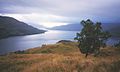
Looking eastwards along Loch Katrine
-
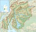
Map of the park
See also
 In Spanish: Parque nacional Lago Lomond y los Trossachs para niños
