Beinn a' Chroin facts for kids
Quick facts for kids Beinn a’ Chroin |
|
|---|---|

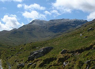
Beinn a‘ Chroin seen from upper Glen Falloch.
|
|
| Highest point | |
| Elevation | 941.4 m (3,089 ft) |
| Prominence | 136.9 m (449 ft) |
| Listing | Munro |
| Naming | |
| English translation | Hill Of The Sheepfold |
| Language of name | Scottish Gaelic |
| Pronunciation | Gaelic |
| Geography | |
| Location | Stirlingshire, Scotland |
| Parent range | Grampians |
| OS grid | NN387185 |
| Topo map | OS Landranger 50, 56 OS Explorer 364 |
Beinn a’ Chroin is a Scottish mountain found in the Stirling area. It's about six kilometers south of a village called Crianlarich. This mountain is really tall, reaching 941.4 meters (about 3,089 feet) high! Because it's so tall, it's known as a "Munro," which is a special name for mountains in Scotland over 3,000 feet.
About Beinn a’ Chroin
Beinn a’ Chroin is part of a group of seven Munros near Crianlarich. People often climb it along with another mountain called An Caisteal. They are only about 1.5 kilometers apart, separated by a mountain pass called Bealach Buidhe.
You can get a great view of Beinn a’ Chroin from the top part of Glen Falloch. From there, you can see its long top ridge and the steep side of Coire Earb, which is like a big, bowl-shaped valley.
The name "Beinn a’ Chroin" comes from the Gaelic language. It has a few possible meanings. Some people think it means "Hill of Danger," but the mountain isn't really more dangerous than others nearby. Other ideas for its meaning are "Hill of the Sheep Fold" or "Hill of the Cloven Hoof." This last meaning might refer to the mountain having two main peaks, like a cloven hoof.
Mountain Landscape
Beinn a’ Chroin is surrounded by four other Munros. These mountains are all around the source of the River Falloch. To the north and east, you'll find Cruach Ardrain and Beinn Tulaichean. You can reach them by a tough path that goes around Coire Earb and up a smaller peak called Stob Glas.
The other two Munros, An Caisteal and Beinn Chabhair, can be reached by following the west ridge down to the Bealach Buidhe. From there, you climb steep slopes to An Caisteal. To get to Beinn Chabhair, you go further down to the west before climbing up to its top.
Coire Earb is an impressive, bowl-shaped valley on the north side of Beinn a’ Chroin. This valley shows amazing examples of boulder fields and moraine. These were formed by glaciers during the last Ice age. A smaller valley called Coire a’ Chroin is on the upper southern slopes. It holds a small lake called Lochan a’ Chroin.
Rainwater from Beinn a’ Chroin flows in two directions. Water from Coire Earb goes west into the River Falloch, eventually reaching the Firth of Clyde on Scotland's west coast. All other rainwater from the mountain flows east to the Firth of Forth on the east coast.
How to Climb Beinn a’ Chroin
Most guidebooks suggest climbing Beinn a’ Chroin along with the nearby Munro, An Caisteal. This hike usually starts from the A82 road. You would climb An Caisteal first, then continue to Beinn a’ Chroin by crossing the Bealach Buidhe.
You can also climb Beinn a’ Chroin directly from the same starting point. This involves walking high into Coire Earb and then climbing the mountain by its north ridge. This ridge leads to the eastern end of the top ridge.
Another way to climb the mountain is from the east. This route starts at the end of a public road that leads to Inverlochlarig. From there, you follow a track by the River Larig to reach the base of the mountain. Then, you climb its steep, grassy south-east slopes.
The top ridge of Beinn a’ Chroin is wavy, with several interesting rock shapes. You might also see some small pools of water near the highest point.
 | Bessie Coleman |
 | Spann Watson |
 | Jill E. Brown |
 | Sherman W. White |

