Cruach Ardrain facts for kids
Quick facts for kids Cruach Ardrain |
|
|---|---|

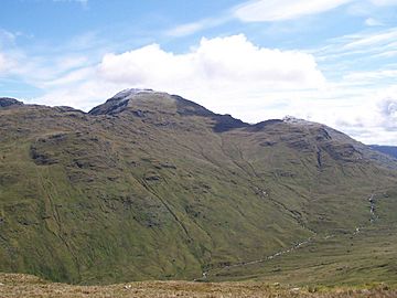
Cruach Ardrain seen across Coire Earb from high up on An Caisteal.
|
|
| Highest point | |
| Elevation | 1,046 m (3,432 ft) |
| Prominence | 549 m (1,801 ft) |
| Parent peak | Ben More |
| Listing | Munro, Marilyn |
| Naming | |
| English translation | Stack of the High Part |
| Language of name | Gaelic |
| Geography | |
| Location | Stirlingshire, Scotland |
| Parent range | Grampians |
| OS grid | NN409212 |
| Topo map | OS Landranger 51, 56 OS Explorer 364 |
| Listed summits of Cruach Ardrain | ||||
| Name | Grid ref | Height | Status | |
|---|---|---|---|---|
| Stob Garbh | NN411221 | 959 m (3146 ft) | Munro Top | |
Cruach Ardrain is a cool mountain in the southern Scottish Highlands. It's a Munro, which means it's one of Scotland's highest peaks, over 3,000 feet tall! You can find it about five kilometres southeast of Crianlarich in the Stirling area.
Contents
What is Cruach Ardrain?
Cruach Ardrain stands out with its pointed shape. It's easy to spot from the nearby village of Crianlarich. The mountain looks like a giant "Y" from above. It reaches a height of 1046 metres (about 3,432 feet).
The name "Cruach Ardrain" comes from the Gaelic language. Its exact meaning can be a bit tricky. Some people say it means "The High Heap." Others think "Cruach" means a stack, so it could be "Stack of the High Part." You might also hear it called "High Mound" or "High Slopes."
Exploring the Mountain
Cruach Ardrain has three main ridges that spread out like the arms of a "Y." These ridges go north, northwest, and south. The southern ridge connects to another Munro called Beinn Tulaichean, which is about two kilometres away. Many hikers climb both mountains on the same trip!
There's also a path that goes southwest from the southern ridge. It leads to a smaller peak called Stob Glas. From there, you can even connect to another Munro, Beinn a' Chroin. Just be careful, as Stob Glas can be steep and rocky.
Coire Ardrain and Climbing Routes
The northern and northeastern ridges form a large bowl-shaped area called Coire Ardrain. This area is rocky at the top and has forests lower down.
Inside Coire Ardrain, you'll find "Y Gully." This is a popular route for scramblers, which is like a mix of hiking and easy rock climbing. In winter, it becomes a great ice climb! Another cool ice climb is "Hollow Gully" on the rocky part of Stob Glas.
Stob Garbh: The Rough Peak
Cruach Ardrain has a special "Munro Top" called Stob Garbh. A Munro Top is a peak that's part of a Munro but not quite a Munro itself. Stob Garbh means "Rough Peak" in Gaelic, and it lives up to its name! It's 959 metres tall and about one kilometre away on the northern ridge.
Stob Garbh is quite rocky, so you need to be careful when walking over it. There's a path that goes around it on the west side, but it can be steep and slippery. It's often safer to stick to the path right over the top. The northwest ridge also has two smaller peaks, Meall Dhamh and Grey Heights, before it drops down to Glen Falloch.
Naismith’s Rule: A Hiking Trick
Did you know a famous Scottish mountaineer named William W. Naismith came up with a clever rule right here? In May 1892, he was walking over Cruach Ardrain on his way to Ben More. That's when he created Naismith's rule.
This rule is a simple way to guess how long a walk will take. It doesn't just look at how far you're going. It also considers how much you have to climb uphill! It's a super helpful trick for hikers.
Reaching the Top
The very top of Cruach Ardrain actually has two high points. They are about 250 metres apart and are almost the same height. Today, maps show the northeast top as the official summit at 1046 metres. This top has a large pile of stones called a cairn.
The most popular way to climb Cruach Ardrain starts from Crianlarich. Hikers often use the northern ridge to go up. This route gives you an exciting scramble over Stob Garbh. Then, you can use the northwest ridge to come back down. Sometimes, the forest at the bottom of the northwest ridge can be a bit tricky to walk through, but there are clear paths.
You can also start your climb from the south. This route has mostly grassy slopes and begins near Inverlochlarig.
 | Jackie Robinson |
 | Jack Johnson |
 | Althea Gibson |
 | Arthur Ashe |
 | Muhammad Ali |


