
Ben More (Crianlarich) facts for kids
Quick facts for kids Ben More |
|
|---|---|
| A' Bheinn Mhòr | |

Ben More from Stob Binnein, illustrating the conical nature of the hill and the tilted rockbands of the mica schist
|
|
| Highest point | |
| Elevation | 1,174 m (3,852 ft) |
| Prominence | c. 986 metres (3,235 ft) Ranked 6th in British Isles |
| Parent peak | Ben Nevis |
| Listing | Munro, Marilyn, Council top (Stirling) |
| Naming | |
| English translation | Big mountain |
| Language of name | Gaelic |
| Pronunciation | Gaelic |
| Geography | |
| Location | Stirling, |
| Parent range | Grampian Mountains |
| OS grid | NN432244 |
| Topo map | OS Landranger 51, Explorer 365 |
Ben More is a famous mountain in the southern Highlands of Scotland. Its name comes from Scottish Gaelic and means "the great mountain." It is located close to the village of Crianlarich.
Ben More is the tallest of the mountains known as the Crianlarich Hills. It is also the highest point in the British Isles south of Ben More itself. This makes it a very important peak. It is separated from another mountain, Stob Binnein, by a col called Bealach-eadar-dha Beinn. This name means "col between two hills." Ben More is also the highest mountain inside the beautiful Loch Lomond and The Trossachs National Park.
Contents
Climbing Ben More
Climbing Ben More is a popular activity for hikers. The easiest way to climb it starts from Benmore Farm. This farm is located on the A85 main road.
You first follow a path that goes up alongside a stream called Benmore Burn. After a while, you leave this path and head up the northwest side of the mountain. This path is quite steep, rising about 1,000 meters (3,280 feet) over a short distance.
Another way to climb Ben More is along its north-east side. This route is a bit rockier but not as steep. To take this path, you follow a stream called Allt Coire Chaorach. Once you are past the trees at the bottom, you head towards the ridge known as Sròn nam Fòirsairean. This route is about 5 kilometers (3 miles) long.
Many climbers like to climb Ben More and Stob Binnein together. After reaching the top of Ben More, they go down to the Bealach-eadar-dha Beinn pass. From there, they can climb up to the second peak. You can also go down directly from the pass back to Benmore Burn.
Interesting Facts About Ben More
Ben More has a special snow patch on its north side. This snow patch lasts for a long time. It is unique in the Southern Highlands because it has a name on maps: the Cuidhe Chrom. This name means "crooked wreath." It gets this name because of its shape in late spring or early summer. This snow often stays until June and sometimes even July.
You can also see Ben More on a webcam. This camera is located at the edge of Crianlarich. It takes new pictures every 10 minutes. You can view it online to see the mountain.
Important Safety Note
Over the years, there have been a few aircraft accidents near Ben More. These incidents remind us that mountains can be challenging places.
On January 19, 1973, a Vickers Viscount plane crashed into Ben More. This happened during a test flight. The plane hit the mountain about 180 meters (600 feet) northeast and 30 meters (100 feet) below the summit. Sadly, everyone on board was killed. Investigators found that the plane was flying over snowy, high ground in poor visibility. They said that not staying at a safe height and not paying enough attention to navigation were reasons for the accident.
Later, on May 12, 2012, a microlight aircraft also crashed into the mountain. Two men died in this accident. These events highlight the importance of safety when flying or exploring in mountainous areas.
Images for kids
-
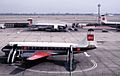
A BEA Vickers Viscount aircraft, similar to the one involved in the 1973 accident.

See also
 In Spanish: Ben More (Crianlarich) para niños
