Stob Binnein facts for kids
Quick facts for kids Stob Binnein |
|
|---|---|

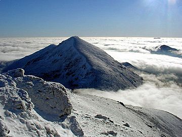
Stob Binnein from Ben More in a winter temperature inversion
|
|
| Highest point | |
| Elevation | 1,165 m (3,822 ft) |
| Prominence | 303 m (994 ft) |
| Parent peak | Ben More |
| Listing | Munro, Marilyn |
| Naming | |
| English translation | Conical peak |
| Language of name | Gaelic |
| Geography | |
| Location | Stirling council area, Scotland |
| OS grid | NN435228 |
| Topo map | OS Landranger 51 and Explorer 365 |
Stob Binnein is a tall mountain in the southern Scottish Highlands, close to Crianlarich. It is known as a twin-peak because it stands right next to Ben More, another large mountain. These two peaks are separated by a special mountain pass called Bealach-eadar-dha Beinn, which means 'pass between two hills' in Scottish Gaelic.
Contents
Exploring Stob Binnein: A Scottish Mountain
Stob Binnein is a popular mountain for hikers and climbers. It stands 1,165 meters (about 3,822 feet) tall. Because of its height, it is classified as a Munro, which is a Scottish mountain over 3,000 feet. It is also a Marilyn, meaning it has a certain prominence above the land around it.
What Does Stob Binnein Mean?
The name "Stob Binnein" comes from the Gaelic language. It means "Conical peak," which perfectly describes its shape. If you look at the mountain, you'll see it has a pointed, cone-like top.
Where is Stob Binnein Located?
This impressive mountain is found in the Stirling council area of Scotland. It is part of the beautiful and rugged landscape of the Scottish Highlands, known for its stunning views and wild nature.
Climbing Stob Binnein: Popular Routes
Many people enjoy climbing Stob Binnein. It is often climbed together with its twin, Ben More. This is usually done by crossing the Bealach-eadar-dha Beinn, the pass that connects the two mountains.
Routes from the North
One common way to climb Stob Binnein is by first climbing Ben More. Once you reach the top of Ben More, you can descend to the Bealach-eadar-dha Beinn and then climb up to Stob Binnein. After visiting both peaks, climbers can descend directly from the pass down to Benmore Burn.
Routes from the South
You can also start your climb from the south. This route begins near a place called Inverlochlarig, which is about 8 kilometers (5 miles) from Balquhidder. This path is about 5 kilometers long and follows the mountain's southern ridge. Along this route, you will pass over smaller hills like Stob Invercarnaig and Stob Coire an Lochain before reaching the main summit of Stob Binnein.
 | Valerie Thomas |
 | Frederick McKinley Jones |
 | George Edward Alcorn Jr. |
 | Thomas Mensah |

