
An Caisteal facts for kids
Quick facts for kids An Caisteal |
|
|---|---|

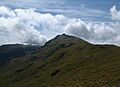
Looking up to the summit of An Caisteal from Twistin Hill on the north ridge.
|
|
| Highest point | |
| Elevation | 995 m (3,264 ft) |
| Prominence | 472 m (1,549 ft) |
| Parent peak | Cruach Ardrain |
| Listing | Munro, Marilyn |
| Naming | |
| English translation | the castle |
| Language of name | Gaelic |
| Geography | |

An Caisteal
Location in Stirling
|
|
| Parent range | Grampians |
| OS grid | NN378193 |
| Topo map | OS Landranger 50, 56 OS Explorer 364 |
| Climbing | |
| Easiest route | North Ridge |
An Caisteal is a cool Scottish mountain. It's about six kilometres south of a village called Crianlarich. This mountain is in the Stirling Council area of Scotland.
Contents
What is An Caisteal?
An Caisteal is a special type of Scottish mountain called a Munro. To be a Munro, a mountain must be over 3,000 feet (914.4 metres) tall. An Caisteal is 995 metres (3,264 feet) high!
It's in a popular spot for hill walking. This area is part of the Loch Lomond and the Trossachs National Park. There are seven Munros and fourteen other peaks nearby.
Why is it called "The Castle"?
The name "An Caisteal" comes from the Gaelic language. It means "the castle." This name fits perfectly because there are rocky parts near the top that look like a castle's walls. These "castle" rocks make it easy to spot the mountain from far away.
Climbing An Caisteal
People often climb An Caisteal along with another Munro called Beinn a' Chroin. These two mountains are connected by a high saddle-like pass. Climbing them together makes for an exciting adventure!
Exploring An Caisteal's Features
An Caisteal is mostly a grassy hill. But it also has some cool rocky areas higher up. Four main ridges stretch out from its summit, like arms reaching in different directions.
The North Ridge: Twistin Hill
The north ridge is the most popular way to climb An Caisteal. It goes over a bumpy, rocky path called Twistin Hill. This path leads to a smaller peak called Sròn Gharbh (709 metres).
As you walk along Twistin Hill, you'll see some interesting things. There are small caves near the path. You might also notice a deep crack cutting into the ridge. It's a fun and unique part of the climb!
Other Ridges
- The north-west ridge also goes down into Glen Falloch. It crosses a peak called Stob Glas (710 metres). This route is less common but still an option.
- The south-west ridge connects to another Munro, Beinn Chabhair. This path involves a steep climb down and then back up over a low pass.
- The south-east ridge links to Beinn a' Chroin. This ridge crosses a pass called Bealach Buidhe (805 metres).
Where the Water Goes
Rainwater from An Caisteal flows in two different directions! Most of it goes into the River Falloch. This river then flows into Loch Lomond and eventually reaches the Firth of Clyde on Scotland's west coast.
However, some water from the southern slopes goes a different way. It flows through Strathyre and the River Teith. This water ends up in the Firth of Forth on Scotland's east coast.
How to Climb An Caisteal
Most people start their climb of An Caisteal from Glen Falloch. There's a big parking area on the A82 road at grid reference NN369239. You can also start from Derrydaroch farm, a bit further south-west.
The route usually begins by going under a railway line through a small tunnel. Then, you follow a track along the River Falloch for about a kilometre. After that, you head south-west and climb straight up the grassy slopes of Sròn Gharbh.
Once you reach the top of Sròn Gharbh, you'll find a clear path. This path leads you across Twistin Hill. It takes you past "The Castle" rocks, which are a great landmark. Finally, the path brings you right to the summit of An Caisteal!
Images for kids
-
Looking up to the summit of An Caisteal from Twistin Hill on the north ridge.
