Beinn Ìme facts for kids
Quick facts for kids Beinn Ìme |
|
|---|---|

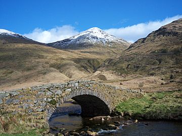
Beinn Ime seen from Butterbridge below Rest and be Thankful.
|
|
| Highest point | |
| Elevation | 1,011 m (3,317 ft) |
| Prominence | c. 696 m |
| Parent peak | Ben Oss |
| Listing | Munro, Marilyn |
| Naming | |
| English translation | Butter mountain |
| Language of name | Scottish Gaelic |
| Pronunciation | Gaelic |
| Geography | |
| Location | Argyll and Bute, Scotland |
| Parent range | Arrochar Alps, Grampian Mountains |
| OS grid | NN255084 |
Beinn Ìme is the tallest mountain in the Arrochar Alps. This mountain range is found in the southern part of the Scottish Highlands in Scotland. Its name, Beinn Ìme, comes from Scottish Gaelic and means "Butter mountain." It stands at 1,011 meters (3,317 feet) high.
Contents
Discovering Beinn Ìme
Beinn Ìme is a very important peak in Scotland. It is known as a Munro, which is a Scottish mountain over 3,000 feet (914.4 meters) tall. It is also a Marilyn, meaning it has a certain height and a significant drop on all sides.
Climbing Beinn Ìme: Popular Routes
There are three main ways to climb Beinn Ìme. Each offers a different adventure for hikers.
Route from Succoth
One common way to reach the top starts from a place called Succoth. You follow a path that also leads to another famous mountain, The Cobbler. Near the base of The Cobbler's rocky cliffs, you take a right turn. This path continues up a valley, crosses a mountain pass (called a bealach), and then goes up Beinn Ìme's eastern side.
Route from Rest and be Thankful
Another way to climb Beinn Ìme is from the Rest and be Thankful pass. This pass is a well-known spot for travelers. From here, climbers can find a route that leads them towards the summit.
Route from Loch Lomond
The third main route begins from the Loch Lomond side. This path uses a private road that goes towards Loch Sloy. This route offers different views as you make your way up the mountain.
Where Beinn Ìme Stands
Beinn Ìme is a natural border between different parts of Scotland. To its east, you'll find the Dunbartonshire area with Loch Lomond. To the north, west, and southwest, it separates the Argyll Highlands, which include Loch Fyne and Loch Goil. Beinn Ìme is like a giant signpost. It marks the entrance to the beautiful region of Argyll.

 | May Edward Chinn |
 | Rebecca Cole |
 | Alexa Canady |
 | Dorothy Lavinia Brown |


