Meall Glas facts for kids
Quick facts for kids Meall Glas |
|
|---|---|

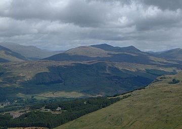
The Meall Glas group of hills from the high ground above Crianlarich, 9 km to the SW. Meall Glas is the highest peak in shade.
|
|
| Highest point | |
| Elevation | 959 m (3,146 ft) |
| Prominence | 554 m (1,818 ft) |
| Parent peak | Beinn Heasgarnich |
| Listing | Munro, Marilyn |
| Naming | |
| English translation | Greenish-grey hill |
| Language of name | Gaelic |
| Geography | |
| Parent range | Grampians |
| OS grid | NN431321 |
| Topo map | OS Landranger 51, OS Explorer 378 |
| Listed summits of Meall Glas | ||||
| Name | Grid ref | Height | Status | |
|---|---|---|---|---|
| Beinn Cheathaich | NN444326 | 937 m (3074 ft) | Munro Top | |
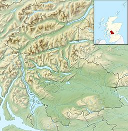
Meall Glas is a mountain located in the southern Scottish Highlands. It sits on the northern edge of the Loch Lomond and the Trossachs National Park, about 8.5 kilometres (5.3 miles) northeast of Crianlarich.
Contents
Discovering Meall Glas: A Scottish Mountain
Meall Glas is known as a Munro, which is a Scottish mountain over 914.4 metres (3,000 feet) high. It stands at 959 metres (3,146 feet) tall. This mountain is the highest point in the rolling uplands between two valleys, Glen Lochay and Glen Dochart. This area doesn't have the dramatic, jagged peaks you might expect from mountains.
Another Munro, Sgiath Chùil, is about 2 kilometres (1.2 miles) to the east. A slightly smaller hill called Beinn nan Imirean (a Corbett) is 2 kilometres to the southwest. Many hikers enjoy climbing all three of these hills in one long walk.
Meall Glas is often overshadowed by the more famous mountains near Crianlarich. Its name comes from the Gaelic words for "Greenish-grey hill." This name perfectly describes its gentle, grassy slopes. People living in Glen Lochay probably gave it this name, as its northern side looks more impressive, with a curving, hollow summit. From Glen Dochart to the south, where most people start their climb, it just looks like the top of a rising moorland.
Exploring the Geography of Meall Glas
Meall Glas is mostly covered in rolling grassy slopes. It has two main ridges, which are like long, narrow elevated sections of land.
- Northwest Ridge: This ridge goes down from the summit towards Glen Lochay. It's one way to climb the mountain.
- East Ridge: This ridge curves around the edge of a bowl-shaped hollow called Coire Cheathaich. It passes over a smaller peak that is 908 metres (2,979 feet) high. Then, it swings northeast to a peak called Beinn Cheathaich, which is 937 metres (3,074 feet) tall. Beinn Cheathaich is about 1.5 kilometres (0.9 miles) from the main Meall Glas peak.
Interestingly, when Sir Hugh Munro first listed these mountains in 1891, he mistakenly listed Beinn Cheathaich as the main Munro and Meall Glas as just a "Top" (a smaller peak connected to a Munro). This mistake was corrected in 1921. From Beinn Cheathaich, the ridge turns north and drops down into Glen Lochay.
To the east, broad slopes lead down to a pass called the Lairig a’ Churain, which is 609 metres (1,998 feet) high. This pass connects Meall Glas to the nearby Munro of Sgiath Chùil.
Rocks and Water
The mountain is made up of schist rocks, which are a type of metamorphic rock. You can also see outcrops of pink granite on the higher parts of the mountain. On the south side, there's a wide, flat area about 450 metres (1,476 feet) high. This "shelf" was formed by glaciers during the Ice Age, which carved away the land.
All the rain that falls on Meall Glas eventually flows to the east coast of Scotland. It travels through the valleys of Dochart (to the south) or Lochay (to the north), then into Loch Tay, and finally into the River Tay.
Climbing Meall Glas: Routes and Views
You can climb Meall Glas from either Glen Dochart or Glen Lochay.
- Southern Approach (Glen Dochart): This is the most popular way to climb because it's easier to get to by car. The path starts at a place called Auchessan (grid reference NN446276) on the A85 road. From there, you walk north across the moorland until you reach the summit ridge, just east of the highest point.
- Northern Approach (Glen Lochay): This route starts at the end of the road in Glen Lochay, at Kenknock (grid reference NN465364). You walk west along the glen for about 1.5 kilometres (0.9 miles), then cross the River Lochay by a ford (the old bridge is gone). After crossing, you follow a track next to the Lubchurran Burn, which goes south and west. This path eventually leads to the summit, passing over the peak of Beinn Cheathaich first.
The very top of Meall Glas is marked by a small pile of stones called a cairn, sitting on a rocky spot. The mountain has a significant prominence of 554 metres (1,818 feet). This means it rises quite high above the surrounding land, making it a great place to see far-reaching views. From the summit, you can enjoy amazing sights of the Mamlorn peaks around the head of Glen Lochay and the Crianlarich hills to the southwest.
 | George Robert Carruthers |
 | Patricia Bath |
 | Jan Ernst Matzeliger |
 | Alexander Miles |


