Beinn Dubhchraig facts for kids
Quick facts for kids Beinn Dubhchraig |
|
|---|---|

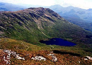
Beinn Dubhchraig seen from Ben Oss across Coire Garbh and Loch Oss.
|
|
| Highest point | |
| Elevation | 978 m (3,209 ft) |
| Prominence | 199 m (653 ft) |
| Parent peak | Ben Oss |
| Listing | Munro, Marilyn |
| Naming | |
| English translation | Mountain of the Black Rock |
| Language of name | Gaelic |
| Geography | |
| Location | Stirlingshire, Scotland |
| Parent range | Grampians |
| OS grid | NN308254 |
| Topo map | OS Landranger 50, OS Explorer 364 |
Beinn Dubhchraig (pronounced "Ben Doo-chraig") is a cool Scottish mountain. It's about eight kilometers (five miles) west of a village called Crianlarich. You can find it in the northern part of the amazing Loch Lomond and The Trossachs National Park. Its name in Scottish Gaelic means "Mountain of the Black Rock."
Contents
What is Beinn Dubhchraig?
This mountain stands tall at 978 meters (about 3,209 feet). Because it's over 914 meters (3,000 feet) high, it's called a Munro. Munros are special mountains in Scotland that many hikers love to climb.
Even though there are taller mountains nearby, you can still see Beinn Dubhchraig clearly. It's easy to spot from the main A82 road. This road runs through Strath Fillan, between Tyndrum and Crianlarich. The name "Mountain of the Black Rock" comes from its steep, rocky side. This side faces southwest, overlooking a loch called Loch Oss. This rocky area is a fun challenge for climbers heading to the top.
Nature and History
Beinn Dubhchraig is part of a group of mountains. These mountains are found near where the River Cononish begins. This group includes two other Munros, Ben Lui and Ben Oss. There's also a Corbett mountain called Beinn Chùirn. (Corbetts are mountains between 762 and 914 meters high).
The valley of Cononish and these four mountains make up the Ben Lui National Nature Reserve. This area is a special place for scientists who study plants. Many unique mountain plants grow here on the moist, rocky cliffs. The soil isn't too acidic, so plants like saxifrage grow everywhere. You might also see large groups of deer in the corries (bowl-shaped valleys) around the mountain.
This area has always been popular for hillwalking. Even before cars, people could easily reach these mountains. This was thanks to the two railway stations in Tyndrum.
The Northern Side
One cool feature of Beinn Dubhchraig is its northern corrie. This is a big, bowl-shaped area between the mountain's north and northeast ridges. A stream called Allt Coire Dubhchraig flows out of this corrie. It heads northeast to join the River Fillan.
At the bottom of this northern corrie, you can still see parts of an old Scots pine forest. This forest is called Coille Coire Chuilc. It's a small piece of the ancient Caledonian Forest that once covered much of Scotland.
Long ago, people used to dig for lead in the northern foothills of the mountain. You can still see marks on the hillside from these old mines. The mines eventually closed in 1923.
Connecting Mountains
Beinn Dubhchraig is connected to another Munro, Ben Oss. Ben Oss is about two kilometers (1.2 miles) to the west. They are linked by a mountain pass called the Bealach Buidhe. This pass is 779 meters (2,556 feet) high. The ridge leading down to the pass is wide. It has a few small lochans (small lakes) in hollows of the rock.
There are corries on both sides of the pass. To the south is Coire Garbh, which holds Loch Oss. This loch is about 500 meters (1,640 feet) long and 300 meters (984 feet) wide. It even has a small island! To the north of the pass is Coire Buidhe. This corrie has a very steep wall. This makes it hard to go straight down from the pass into the Cononish valley.
To the east, Beinn Dubhchraig slopes down into Gleann Auchreoch valley. In the early 1970s, many conifer trees were planted on these lower eastern slopes. This can make it a bit tricky to approach the mountain from that direction now.
How to Climb Beinn Dubhchraig
A popular way to climb Beinn Dubhchraig starts from a small village called Dalrigh. Dalrigh is on the A82 road. You can find it at grid reference NN343292.
From Dalrigh, you follow a track that crosses the railway. This track then goes through the woods, following the Allt Coire Dubhchraig stream. The path can get muddy. You'll cross three deer fences using special stiles. After this, you reach the open mountainside. From here, you can climb directly up the northern corrie. This leads you to the flat area near the summit.
Many hikers climb Beinn Dubhchraig along with other mountains in the Cononish valley. From the top, you get amazing views. You can see the mountains of Breadalbane to the west. The two Munros, Ben More and Stob Binnein, are also clearly visible to the southeast.
 | Charles R. Drew |
 | Benjamin Banneker |
 | Jane C. Wright |
 | Roger Arliner Young |

