Beinn Challuim facts for kids
Quick facts for kids Beinn Challuim |
|
|---|---|

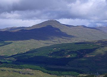
Beinn Challuim seen from the high ground around Crianlarich, 12 km to the south.
|
|
| Highest point | |
| Elevation | 1,025 m (3,363 ft) |
| Prominence | 450 m (1,480 ft) |
| Listing | Munro, Marilyn |
| Naming | |
| English translation | Malcolm’s Peak |
| Language of name | Gaelic |
| Geography | |
|
Lua error in Module:Location_map at line 420: attempt to index field 'wikibase' (a nil value).
|
|
| Parent range | Grampians |
| OS grid | NN386322 |
| Topo map | OS Landranger 50, OS Explorer 378 |
Beinn Challuim (also known as Ben Challum) is a Scottish mountain. It is found in the northern part of the Loch Lomond and The Trossachs National Park. This mountain stands about six kilometres east of the village of Tyndrum. It is located in the Stirling Council area. The mountain is part of the ancient Forest of Mamlorn, which was once a special area for deer hunting.
About Beinn Challuim
Beinn Challuim is 1025 metres (3363 feet) tall. It is known as a Munro because it is over 3000 feet high. It is also a Marilyn, meaning it stands out quite a bit from the land around it. The mountain is at the top of Glen Lochay. Its western side is a big feature in Strath Fillan. If you look from the south, you cannot see the very top of the mountain. This is because a smaller peak, called the South Top, blocks the view.
The mountain's name, Beinn Challuim, means "Malcolm's mountain." However, some people think the older spelling might refer to Saint Columba. He is known as "Calum Cille" in Scottish Gaelic. There is a priory (a type of monastery) dedicated to St. Fillan nearby. St Fillan brought Christianity to the area from St Columba's monastery on Iona. This connection makes the idea of the name referring to St. Columba quite possible.
Mountain Features
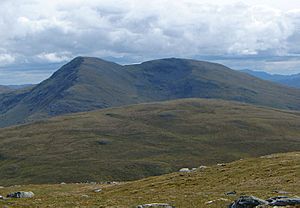
Many people see Beinn Challuim as a smooth, grassy hill. This is true for its southern and western sides, which are visible from the A82 road. But if you look from the north, the mountain looks much more rugged. It has a steep, rocky face that overlooks Glen Lochay.
Beinn Challuim has three main ridges, which are like long, narrow hills.
- The wide, grassy southwest ridge goes down to Strath Fillan. This is a common path for climbers.
- The northwest ridge is steep and rocky. It leads to a mountain pass called the Bealach Ghlas-Leathaid. From there, it connects to another mountain called Cam Chreag.
- Another ridge goes east, leading down into Glen Lochay.
The mountain also has a smaller peak called the South Top. This peak is 998 metres (3274 feet) high. It is about 600 metres south of the main summit. The two peaks are connected by a ridge. If the weather is foggy, it can be tricky to find the right path between them. The best way from the South Top to the main summit is to go west a short distance first. Then, you can easily follow the ridge north to the main peak.
The summit ridge has two corries, which are bowl-shaped hollows formed by glaciers. To the west is Coire nan Each, meaning "Corrie of the Horse." To the east is Coire Challuim, or "Malcolm's Corrie." Rainwater and snowmelt from the mountain flow into rivers that reach both the east and west coasts of Scotland. These waters eventually reach the Firth of Tay on the east and the Firth of Clyde on the west.
Climbing Beinn Challuim
The most popular way to climb Beinn Challuim starts at Kirkton Farm in Strath Fillan. This route lets you visit the old ruins of St. Fillan's Priory. From the farm, you walk northeast up grassy slopes to reach the summit ridge.
Another interesting way to climb the mountain starts at the end of the road in Glen Lochay. This path lets you see the more impressive northern side of the mountain. However, it involves a nine-kilometre walk up the glen to reach the base of the eastern ridge. Some experienced climbers also suggest a northern approach starting from Auch. This route is more challenging and requires good navigation skills. It also involves some easy scrambling up the northwest ridge.
The very top of the mountain is called Stob Glas, which means "greenish-grey peak." There is a large cairn (a pile of stones) at the summit. From here, you can see amazing views of the many mountains around the Tyndrum and Crianlarich areas.
 | George Robert Carruthers |
 | Patricia Bath |
 | Jan Ernst Matzeliger |
 | Alexander Miles |


