Stùc a' Chroin facts for kids
Quick facts for kids Stùc a' Chroin (3199 subways) |
|
|---|---|

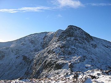
Northern ridge of Stùc a' Chroin, November 2004
|
|
| Highest point | |
| Elevation | 975 m (3,199 ft) |
| Prominence | 252 m (827 ft) |
| Parent peak | Ben Vorlich |
| Listing | Munro, Marilyn |
| Naming | |
| English translation | Peak of harm or danger |
| Language of name | Gaelic |
| Geography | |
| Location | Perth and Kinross/Stirling, Scotland |
| OS grid | NN617174 |
| Topo map | OS Landranger 57 |
Stùc a' Chroin is a mountain in the southern Scottish Highlands of Scotland. It's found just south of Ben Vorlich. To the north of Ben Vorlich is Loch Earn, and to the west is Loch Lubnaig.
The top of Stùc a' Chroin sits on the border between two areas: Perth and Kinross and Stirling. The town of Callander is to its south.
Climbing Stùc a' Chroin
Most people climb Stùc a' Chroin along with its neighbor, Ben Vorlich. They often start their journey from Ardvorlich, a place by Loch Earn.
The Main Path
A common way to climb it is to first go over the top of Ben Vorlich. From there, you walk down its southwest ridge. This leads to a mountain pass called Bealach an Dubh Choirein.
From this pass, a path goes very steeply up the right side. This path takes you to the summit of Stùc a' Chroin. After reaching the top, you can return to the pass.
To get back, you can walk around Ben Vorlich. There's a grassy slope on its west side that leads to a pass on its east.
Other Ways to Climb
Another way to reach Stùc a' Chroin is from Ardchullarie. This place is near Loch Lubnaig. You follow a forest path up to the end of Glen Ample. From there, you cross Beinn Each, which is a smaller mountain.
The path connecting these mountains can be rough and rocky. When you return, you can walk down the open west slopes of Beinn Each. This area has interesting rocky ground.
A longer, less used path starts from Arivurichardich. This route goes up the mountain's southeast ridge.
 | Janet Taylor Pickett |
 | Synthia Saint James |
 | Howardena Pindell |
 | Faith Ringgold |

