
St Fillans facts for kids
St Fillans is a small village in the beautiful Highlands of Scotland. It is located in the area called Perth and Kinross. You can find St Fillans at the eastern end of Loch Earn, about 5 miles (8 km) west of Comrie. The village sits right where the River Earn flows out of the loch.
Long ago, in the 1700s, St Fillans was a tiny village known as Port of Lochearn or Meikleport. But in 1817, it was given its current name, St Fillans. This happened because Lord Gwydyr, whose wife Clementina Drummond owned the land, decided to rename it.
Quick facts for kids St Fillans
|
|
|---|---|
 St Fillans, from the southern bank of Loch Earn |
|

St Fillans
|
|
| Civil parish | |
| Council area | |
| Lieutenancy area | |
| Country | Scotland |
| Sovereign state | United Kingdom |
| Police | Tayside |
| Fire | Tayside |
| Ambulance | Scottish |
| EU Parliament | Scotland |
| UK Parliament |
|
| Scottish Parliament |
|
Contents
History and Old Buildings
St Fillans has a rich history, with connections to an ancient saint and old stories.
St Fillan's Chapel
There is an old church building called St Fillan's Chapel near the village. It was built before the Reformation, a big change in the Christian church. The chapel's graveyard is a special burial place for the Stewarts of Ardvorlich family.
Dundurn Hill Fort
The chapel is located between St Fillans and an ancient Iron Age hill fort called Dundurn. This fort was built by the Picts, an ancient people of Scotland. It is believed that an Irish missionary named Saint Fillan lived on this hill a very long time ago.
A Poet's Inspiration
Close to Dundurn Hill, there is a small stream called Allt Ghoinean. Some people say this stream is the "Gonan" or "Monan" mentioned in The Lady of the Lake. This famous poem was written by the well-known Scottish writer Sir Walter Scott.
Modern St Fillans
Even though it's an old village, St Fillans also has modern features and attractions.
Hidden Power Station
St Fillans is home to a large hydro-electric power station. This station creates electricity using the power of water. It gets its water from a dam at Loch Lednock, high above the village. What's really cool is that you can't see the power station in St Fillans. It's built completely underground, carved out of solid rock! It's part of a bigger system called the Breadalbane Hydro-Electric Scheme.
Golf Course Fun
If you like golf, St Fillans has a golf course that was built in 1903. It was designed by a famous golf professional named Willie Auchterlonie.
Protecting Nature
The area around St Fillans is very beautiful and is protected.
National Scenic Area
The part of the River Earn that flows from St Fillans down to Comrie is very special. This area, along with much of the surrounding countryside, is called a National Scenic Area (NSA). Scotland has 40 such areas. They are chosen because they have amazing scenery. This special title helps make sure the beautiful landscape is protected from certain types of building or development. The River Earn (Comrie to St Fillans) NSA covers about 12 square miles (31 square kilometers).
Local Legends
St Fillans has some interesting local stories, including one about fairies!
The Fairy Rock
In 2005, there was a plan to build new houses in St Fillans. But the building work was stopped because some people believed that fairies lived under a rock on the site! After talking things over, the plans for the new houses were changed. The special rock was saved and is now in a small park in the middle of the housing area.
St Fillans Creatures
Just east of St Fillans, along the A85 road, you can find two unique stone figures. One is known as the St Fillans Dragon, and the other is the St Fillans Toad.

Images for kids
-
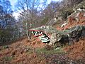
St Fillans dragon from the side
