
List of postcode areas in the United Kingdom facts for kids
The list of postcode areas in the United Kingdom shows the main areas used by Royal Mail to help deliver mail across the United Kingdom. A postcode area is the biggest part of a postcode, which is like a special address code. It's the first few letters you see in a UK postcode. There are currently 121 postcode areas in the UK. Plus, there are three more for the Crown Dependencies of Guernsey, Jersey, and the Isle of Man.
Contents
How Postcode Areas are Divided
Each postcode area is split into smaller parts called post towns and postcode districts. On average, there are about 20 postcode districts within one postcode area. However, London is different. Its main post town is actually divided into several postcode areas itself!
What Do Postcode Areas Cover?
The letters used for postcode areas often help you remember the place they cover, like "ED" for Edinburgh. But these postcode areas, post towns, and districts don't follow official government borders. They usually cover much bigger areas than the town or city they are named after. For example, in the PA postcode area, some parts are 140 miles apart! Also, the eight postcode areas for London only cover about 40% of Greater London. The rest of Greater London is covered by parts of twelve other postcode areas around it.
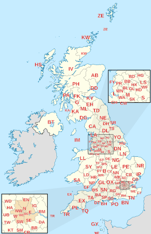
Main Postcode Areas in the UK
Here's a list of the main postcode areas in the UK:
| Postcode area | Postcode area name | How the code was formed | Number of postcode districts |
|---|---|---|---|
| AB | Aberdeen | 33 | |
| AL | St Albans | 10 | |
| B | Birmingham | 79 | |
| BA | Bath | 19 | |
| BB | Blackburn | 13 | |
| BD | Bradford | 27 | |
| BH | Bournemouth | 26 | |
| BL | Bolton | 10 | |
| BN | Brighton | 30 | |
| BR | Bromley | 8 | |
| BS | Bristol | 37 | |
| BT | Belfast | 81 | |
| CA | Carlisle | 28 | |
| CB | Cambridge | 16 | |
| CF | Cardiff | 35 | |
| CH | Chester | 37 | |
| CM | Chelmsford | 25 | |
| CO | Colchester | 16 | |
| CR | Croydon | 9 | |
| CT | Canterbury | 21 | |
| CV | Coventry | 24 | |
| CW | Crewe | 12 | |
| DA | Dartford | 18 | |
| DD | Dundee | 11 | |
| DE | Derby | 23 | |
| DG | Dumfries | Dumfries and Galloway | 15 |
| DH | Durham | 9 | |
| DL | Darlington | 17 | |
| DN | Doncaster | 32 | |
| DT | Dorchester | 11 | |
| DY | Dudley | 14 | |
| E | East London | 20 | |
| EC | East Central London | 23 | |
| EH | Edinburgh | 54 | |
| EN | Enfield | 11 | |
| EX | Exeter | 33 | |
| FK | Falkirk | 21 | |
| FY | Blackpool | The Fylde | 8 |
| G | Glasgow | 52 | |
| GL | Gloucester | 27 | |
| GU | Guildford | 38 | |
| HA | Harrow | 10 | |
| HD | Huddersfield | 9 | |
| HG | Harrogate | 5 | |
| HP | Hemel Hempstead | 24 | |
| HR | Hereford | 9 | |
| HS | Hebrides | 9 | |
| HU | Hull | 20 | |
| HX | Halifax | 7 | |
| IG | Ilford | Possibly Ilford and Gants Hill | 11 |
| IP | Ipswich | 33 | |
| IV | Inverness | 52 | |
| KA | Kilmarnock | Possibly Kilmarnock and Ayr | 30 |
| KT | Kingston upon Thames | 24 | |
| KW | Kirkwall | 16 | |
| KY | Kirkcaldy | 16 | |
| L | Liverpool | 40 | |
| LA | Lancaster | 23 | |
| LD | Llandrindod Wells | 8 | |
| LE | Leicester | 21 | |
| LL | Llandudno | 67 | |
| LN | Lincoln | 13 | |
| LS | Leeds | 29 | |
| LU | Luton | 7 | |
| M | Manchester | 43 | |
| ME | Medway | 20 | |
| MK | Milton Keynes | 26 | |
| ML | Motherwell | 12 | |
| N | North London | 23 | |
| NE | Newcastle upon Tyne | 61 | |
| NG | Nottingham | 29 | |
| NN | Northampton | 19 | |
| NP | Newport | 18 | |
| NR | Norwich | 35 | |
| NW | North West London | 11 | |
| OL | Oldham | 16 | |
| OX | Oxford | 27 | |
| PA | Paisley | 67 | |
| PE | Peterborough | 38 | |
| PH | Perth | 43 | |
| PL | Plymouth | 35 | |
| PO | Portsmouth | 34 | |
| PR | Preston | 11 | |
| RG | Reading | 30 | |
| RH | Redhill | 20 | |
| RM | Romford | 20 | |
| S | Sheffield | 45 | |
| SA | Swansea | 51 | |
| SE | South East London | 28 | |
| SG | Stevenage | 19 | |
| SK | Stockport | 19 | |
| SL | Slough | 10 | |
| SM | Sutton | Possibly Sutton and Morden | 7 |
| SN | Swindon | 18 | |
| SO | Southampton | 23 | |
| SP | Salisbury | Salisbury Plain | 11 |
| SR | Sunderland | 8 | |
| SS | Southend-on-Sea | 17 | |
| ST | Stoke-on-Trent | 21 | |
| SW | South West London | 27 | |
| SY | Shrewsbury | 25 | |
| TA | Taunton | 24 | |
| TD | Galashiels | Tweeddale | 15 |
| TF | Telford | 13 | |
| TN | Tunbridge Wells | 40 | |
| TQ | Torquay | 14 | |
| TR | Truro | 27 | |
| TS | Teesside | 29 | |
| TW | Twickenham | 20 | |
| UB | Southall | Uxbridge | 11 |
| W | West London | 26 | |
| WA | Warrington | 16 | |
| WC | West Central London | 14 | |
| WD | Watford | 11 | |
| WF | Wakefield | 17 | |
| WN | Wigan | 8 | |
| WR | Worcester | 15 | |
| WS | Walsall | 15 | |
| WV | Wolverhampton | 16 | |
| YO | York | 29 | |
| ZE | Lerwick | Zetland | 3 |
Postcode Areas for Crown Dependencies
The Crown Dependencies are not part of the UK, but they use similar postcode systems. They have their own postal services.
| Postcode area | Postcode area name |
|---|---|
| GY | Guernsey |
| JE | Jersey |
| IM | Isle of Man |
Postcode Areas That Are No Longer Used
Over time, some postcode areas have been changed or stopped being used.
London's Old Postcode Areas
London used to have postcode areas like NE (North East) and S (South), but these were removed.
Glasgow's Old System
Glasgow also had an old system where it was divided into compass directions (like C for Central, W for West). When new postcodes came in, these old divisions were changed to fit the new "G" postcode area. For example, C1 became G1.
Norwich and Croydon Experiments
In the 1960s, Norwich and Croydon were part of a postcode experiment. Their postcodes looked different, like NOR 07A. This system was later replaced by the current one, and they became CR0 and NR1.
Dublin's "D" Postcode
When Ireland was part of the United Kingdom, Dublin was given the postcode letter "D". Even after Ireland became independent, they kept this "D" for Dublin. The UK has never used "D" for a postcode area since then.
Special Postcodes That Aren't Geographic
Some postcode areas don't point to a specific place on a map. They are used for special purposes.
BF for British Forces
The BF postcode area was created in 2012 for British Forces Post Office addresses. This helps their mail look like other UK addresses. It uses the post town "BFPO" and the postcode district "BF1".
BX for Big Organisations
The BX postcode area is used for addresses that don't have a specific location. This gives large companies flexibility in where they receive their mail. For example, big banks like Lloyds Banking Group and HSBC use BX postcodes. Parts of HM Revenue and Customs (who deal with taxes) also use them.
GIR for Girobank
GIR 0AA is a special postcode made for Girobank in Bootle. Even after Girobank was taken over by other banks, this postcode is still used.
XM for Father Christmas
Yes, you read that right! XM4 5HQ is a postcode created just for Father Christmas.
XX for Returns and Testing
The XX postcode area is used by online shops for customer returns through Royal Mail. It's also used for things like COVID-19 test samples.
| User | XX Postcodes |
|---|---|
| Adidas | XX40 4AA |
| Amazon | XX10 1DD, XX10 1ZZ, XX30 1FF, XX40 2PP, XX50 1DD, XX50 9SS, XX60 1XX |
| ASOS | XX10 1AA |
| Boohoo.com | XX10 1BB |
| BT Group | XX10 1BT |
| John Lewis | XX10 1EE, XX40 1EE |
| Marks & Spencer | XX10 1SS |
| Very | XX20 1DD |
| musicMagpie | XX10 1FF, XX20 1BF, XX20 1FF |
| HP / Cycleon Retail Returns | XX40 1EH, XX40 2HH |
| Nike | XX40 2HH |
| Zara | XX40 1EJ |
| Mango | XX40 1EN |
| Monsoon Accessorize | XX40 1EP |
| Boden | XX40 1EG |
| H&M | XX40 1HN |
| Oasis | XX40 1YY |
| Shein | XX40 3SS |
| Temu | XX40 1ZZ |
| Sky | XX40 4UU |
| Biocentre (COVID-19 testing) | XX40 4FL |
| AstraZeneca (COVID-19 testing) | XX40 8AZ |
| Biocentre (COVID-19 testing) Scotland | XX50 5FL |
Postcodes for Overseas Territories
Some British Overseas Territories have their own postcodes. These are not UK postcodes, even if they look similar. Mail sent from the UK to these territories is treated as international mail.
| Territory | Postcode |
|---|---|
| AI-2640 | |
| Saint Helena, Ascension and Tristan da Cunha: | ASCN 1ZZ STHL 1ZZ TDCU 1ZZ |
| BBND 1ZZ | |
| BIQQ 1ZZ | |
| FIQQ 1ZZ | |
| GX11 1AA | |
| PCRN 1ZZ | |
| SIQQ 1ZZ | |
| TKCA 1ZZ |
Other overseas territories have their own, more detailed postcode systems:
| Overseas Territory | More information |
|---|---|
| Postal codes in Bermuda | |
| Postal codes in the Cayman Islands | |
| Postal codes in the British Virgin Islands | |
| Postal codes in Montserrat |
People living and working in Akrotiri and Dhekelia use Cyprus Postal Services and their Cypriot postal codes.
See also
- List of postcode areas in the United Kingdom by population
- List of postcode districts in the United Kingdom
- Postcodes in the United Kingdom
- UK Postcode Regions by Population
- List of Eircode routing areas in Ireland
