British Antarctic Territory facts for kids
Quick facts for kids
British Antarctic Territory
|
|||
|---|---|---|---|
|
|||
| Motto(s):
"Research and Discovery"
|
|||
| Anthem: "God Save the King" |
|||

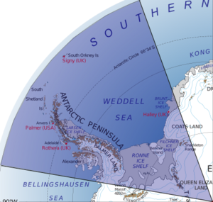
Location of the British Antarctic Territory in Antarctica
|
|||
| Sovereign state | |||
| Territory | 1908 | ||
| Capital and largest city
|
Rothera 67°34′06″S 68°07′33″W / 67.568417°S 68.125796°W |
||
| Official languages | English | ||
| Government | Dependency under a constitutional monarchy | ||
|
• Monarch
|
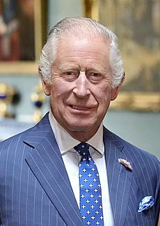
Charles III | ||
| Paul Candler | |||
|
• Deputy Commissioner
|
Jane Rumble | ||
|
• Administrator
|
George Clarkson | ||
| Area | |||
|
• Total
|
1,709,400 km2 (660,000 sq mi) | ||
| Highest elevation | 3,239 m (10,627 ft) | ||
| Population | |||
|
• Summer estimate
|
250 | ||
| Currency | Pound sterling (£) (GBP) | ||
| Time zone | UTC-03:00 | ||
| UK postcode |
BIQQ 1ZZ
|
||
| Internet TLD | |||
The British Antarctic Territory (BAT) is a large area in Antarctica. The United Kingdom claims it as one of its 14 British Overseas Territories. It is the biggest of these territories by size.
The BAT is a wedge-shaped area. It stretches from 60°S latitude down to the South Pole. It lies between 20°W and 80°W longitude. Other countries like Argentina and Chile also claim parts of this region. However, since 1961, these claims have been paused because of the Antarctic Treaty. This treaty makes sure Antarctica is used for peaceful research only.
The territory was officially created on 3 March 1962. But the UK's claim to this part of Antarctica goes back to 1908. Before 1962, parts of the area were managed by the UK as separate areas of the Falkland Islands. These included Graham Land, the South Orkney Islands, and the South Shetland Islands.
Today, the territory is home to scientists and support staff. They work at research stations run by the British Antarctic Survey and other groups. There are no people who live there all the time. In 2012, the southern part of the territory was named Queen Elizabeth Land. This was done to honor Queen Elizabeth II.
Contents
History of the British Antarctic Territory
The United Kingdom has been present in the far South Atlantic since 1833. That's when it took back control of the Falkland Islands. In 1908, the UK officially claimed more land. This included South Georgia, the South Orkneys, the South Shetlands, the South Sandwich Islands, and Graham Land. These areas were south of 50°S latitude and between 20°W and 80°W longitude. All these lands were managed from the Falkland Islands.
In 1917, the UK changed its claim. This new claim clearly included all land in the sector reaching the South Pole. This covers the entire British Antarctic Territory we know today.
The UK also claimed Victoria Land in 1841 and Enderby Land in 1930. However, in 1933, all land between 160°E and 45°E was given to Australia. During World War II in 1943, the UK started a secret military mission called Operation Tabarin. Its goal was to gather weather information in the South Atlantic. This project later became the British Antarctic Survey (BAS). BAS now does most of the UK's scientific research in Antarctica.
In the 1950s, countries worked together to create the Antarctic Treaty. This treaty aimed to keep Antarctica peaceful and free of military activity. It also made sure the continent was used only for scientific research. The treaty was signed in 1961. It applies to all land and ice south of 60°S latitude.
Who Recognizes the British Antarctic Territory?
The Antarctic Treaty was signed by many countries. It doesn't say if any country's land claims in Antarctica are right or wrong. Most countries around the world do not recognize any national claims to Antarctica.
However, Australia, France, New Zealand, Norway, and the United Kingdom all have claims. These countries recognize each other's claims. Argentina and Chile do not agree with the British claim. They have their own claims that overlap with both Britain's and each other's.
Geography of the British Antarctic Territory

Land and Ice
The British Antarctic Territory includes the Antarctic Peninsula. It also has the South Shetland Islands, South Orkney Islands, and many other islands. The Ronne Ice Shelf and parts of Coats Land are also in the territory. In December 2012, a large triangle of central Antarctica was named Queen Elizabeth Land. This was to honor Queen Elizabeth II's Diamond Jubilee. This area is about 437,000 square kilometers, which is almost twice the size of the UK.
More than 99% of the territory is covered by a permanent ice sheet. This ice can be up to 5,000 meters thick. The highest point in the BAT is Mount Hope. It is 3,239 meters tall.
Plants and Animals
There are very few plants in the British Antarctic Territory. Most of them are mosses and lichens. There are also two types of flowering plants: the Antarctic hairgrass and Antarctic pearlwort.
Many different birds live and breed here, including seven kinds of penguin. The territory is also home to six types of seals.
Oil and Gas Discoveries
In 2024, it was reported that Russia had found large amounts of oil and gas in Antarctica. A big part of these reserves was in areas claimed by the United Kingdom. The estimated amount is 511 billion barrels of oil. This raises questions because the Antarctic Treaty protects the region. It stops any mining or oil drilling. The UK's Foreign Office trusts that Russia is only doing scientific research. However, some people worry that Russia's activities look more like searching for oil and gas.
How the British Antarctic Territory is Managed

The British Antarctic Territory is managed by the Foreign and Commonwealth Office (FCO) in the UK. A special leader called a Commissioner is chosen. This person is always the Director of the FCO's Overseas Territories team.
The territory has its own laws and postal service. But because of the Antarctic Treaty System, it does not make foreign countries follow its laws if they have scientific bases there. The territory pays for itself by selling postage stamps and collecting income tax.
The Royal Navy sends a ship called HMS Protector to the South Atlantic and Antarctic waters during the summer. This ship helps the British Antarctic Survey. The British Antarctic Survey also uses the ship RRS Sir David Attenborough in the region during the Antarctic summer.
Research Stations
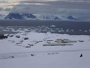
The British Antarctic Survey has two stations that are open all year in the territory. These are Halley Research Station and Rothera Research Station.
Signy Research Station was open from 1947 to 1996. Now, it is only staffed in the summer. There are also two smaller stations, Fossil Bluff and Sky Blu, used only in summer. Another station, Faraday, was used until 1996. It was then sold to Ukraine and renamed Akademik Vernadsky Station.
Since 1996, the old base at Port Lockroy on Goudier Island has been open in the Antarctic summer. It is run by the UK Antarctic Heritage Trust. About 10,000 visitors come each year, making it a very popular spot. Visitors can see a museum, buy souvenirs, send mail, and watch a large group of gentoo penguins. Argentina has also had a presence in the territory since 1903, with the Orcadas Base on the South Orkney Islands. Many other countries also have bases in the territory, especially in the South Shetland Islands.
Stamps and Coins
Even though there are no permanent residents, the British Antarctic Territory issues its own postage stamps. Some are used by tourists and scientists. But most are sold to stamp collectors around the world. The first stamps came out in 1963.
In 2008–2009, the British Antarctic Territory made its first legal coin. This was part of the celebrations for 100 years since the UK first claimed the territory in 1908.
Queen Elizabeth Land
On 18 December 2012, the Foreign and Commonwealth Office announced a new name for the southern part of the British Antarctic Territory. It was named Queen Elizabeth Land to honor Queen Elizabeth II during her Diamond Jubilee year. This area is about 437,000 square kilometers, which is almost twice the size of the United Kingdom. It is roughly shaped like a triangle, with the South Pole at one corner. The Filchner-Ronne Ice Shelf and Coats Land form its northern border.
The name "Queen Elizabeth Land" will be used on all British maps. However, because of Antarctica's special status, other countries can decide if they want to use the name or not. Argentina, which also claims part of this area, did not agree with the naming.
See also
 In Spanish: Territorio Antártico Británico para niños
 | Calvin Brent |
 | Walter T. Bailey |
 | Martha Cassell Thompson |
 | Alberta Jeannette Cassell |


