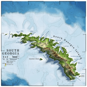
South Georgia facts for kids
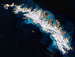
February 2018 ESA satellite photograph of South Georgia
|
|
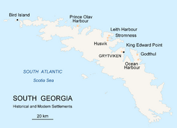
Map of South Georgia Island
|
|
| Geography | |
|---|---|
| Location | South Atlantic Ocean |
| Coordinates | 54°24′S 36°42′W / 54.4°S 36.7°W |
| Archipelago | South Georgia Group |
| Area | 3,528 km2 (1,362 sq mi) |
| Length | 170 km (106 mi) |
| Width | 35 km (21.7 mi) |
| Highest elevation | 2,934 m (9,626 ft) |
| Highest point | Mount Paget |
| Administration | |
| Overseas Territory | South Georgia and the South Sandwich Islands |
| Largest settlement | King Edward Point |
| Demographics | |
| Population |
|
South Georgia is a long island located in the South Atlantic Ocean. It is part of a special area called the British Overseas Territory of South Georgia and the South Sandwich Islands. This island is about 1,400 kilometers (870 miles) east of the Falkland Islands.
South Georgia stretches for about 170 kilometers (106 miles) from east to west. At its widest point, it is about 35 kilometers (22 miles) across. The island has many mountains, with its highest peak, Mount Paget, reaching 2,935 meters (9,629 feet) high. The northern coast has many bays and deep inlets called fjords, which are great natural harbors.
Europeans first found South Georgia in 1675. Because of its cold weather and how far away it is, no native people ever lived there. Captain James Cook was the first to land on the island. On January 17, 1775, he explored and mapped it. He then claimed it for Britain and named it "Isle of Georgia" after King George III. For many years, the island was a base for whaling (hunting whales) and seal hunting. Today, the main settlement and capital is King Edward Point, which is close to the historic whaling station of Grytviken. It is now a research station with about 20 people living there.
Island History: Discoveries and Explorers
The island of South Georgia was likely first seen in 1675 by Anthony de la Roché, a merchant from London. Some old maps called it Roche Island. A Spanish ship named León also saw the island in 1756. Argentine historians say it was explored on June 29, 1756, which was St Peter's Day. Because of this, its Spanish name is Isla San Pedro, meaning "St Peter's Island."
Captain Cook's Exploration
The famous sailor Captain James Cook was the first to land on South Georgia. He also mapped the island for the first time. On January 17, 1775, he officially claimed it for Britain. He renamed the island 'Isle of Georgia' in honor of King George III.
Ernest Shackleton's Amazing Journey
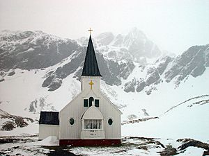
After a difficult journey across the island with Tom Crean and Frank Worsley, Ernest Shackleton helped rescue his team. Their expedition, the 1916 Imperial Trans-Antarctic Expedition, had faced a disaster. Shackleton is buried in the cemetery at Grytviken next to Frank Wild.
Sealing and Whaling Activities
People hunted seals on the island for money between 1786 and 1913. Records show 131 sealing trips during this time. Eight of these trips ended with the ship being wrecked. Later, from 1909 to 1964, large-scale industrial sealing happened alongside whaling stations. You can still find old items from the sealing era, like iron pots used to melt blubber, old hut ruins, and graves. The South Georgia Museum was opened on the island in 1992 to show these historical items.
Duncan Carse's Surveys
The explorer Duncan Carse carefully mapped the island. He led the South Georgia Survey from 1951 to 1957. During this time, his team mapped much of the island's inner areas. Mount Carse and Carse Point are named after him. In 1961, he tried to live alone like a hermit in a remote part of South Georgia. He built a house at Ducloz Head on the southern coast. However, three months into his stay, large waves destroyed his camp. He managed to save enough gear to survive the winter. He finally made contact with a ship 116 days later. His detailed maps and knowledge were very helpful to the British during the Falklands conflicts.
Conflict and Recovery
On March 19, 1982, a group of Argentinians arrived at Leith Harbour and raised the Argentine flag. On April 3, during the Falklands War, Argentine naval forces took control of the island. However, British forces quickly took South Georgia back on April 25 in an operation called Operation Paraquet.
Geography and Wildlife of South Georgia
South Georgia has a very cold climate, known as a polar tundra climate. This means there are no trees growing on the island. Snow usually covers the island during the winter months, from April to November. The land is mountainous, with a central ridge and many deep bays and fjords along the coast.
Amazing Animals of the Island
South Georgia is a very important place for many animals to breed. It is home to large numbers of elephant seals, fur seals, and king penguins. Two special birds, the South Georgia pintail and the South Georgia pipit, live only on this island.
Plants and Invasive Species
There are 25 types of native plants on South Georgia. However, 76 types of plants that are not native to the island have also been found.
In 2013, teams of Norwegian shooters and Sámi reindeer herders removed all 3,500 reindeer from the island. Norwegian whalers had brought these animals to the island in the early 1900s for food and hunting. But the reindeer started to cause problems. They were damaging the island's plants and the natural environment. The reindeer that were removed were frozen and sent to the Falkland Islands. There, they were sold to local people and cruise ship companies.
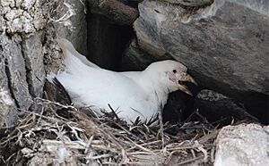
By 2018, after many years of effort, the island was declared free of invasive rodents (like rats). After the rats were removed, the number of South Georgia pipits clearly increased. In the central north coast area, five years after the rats were poisoned, the populations of snowy sheathbills, South Georgia pintails, and Wilson's storm petrels had all grown.
Giant Icebergs and Their Impact
The island is in the path of huge icebergs that float north from Antarctica. In 2004, a very large iceberg called Iceberg A-38 got stuck near the island. This caused problems for the local wildlife. It disturbed life on the seafloor and blocked the paths that seals and penguins used to find food. In 2020, another giant iceberg, Iceberg A-68, was about the same size as the island itself. It was thought to be heading for a collision, but it broke apart before it could hit the island.
|
See also
 In Spanish: Isla San Pedro (Georgia del Sur) para niños
 | James B. Knighten |
 | Azellia White |
 | Willa Brown |


