
Mount Paget facts for kids
Quick facts for kids Mount Paget |
|
|---|---|

Mount Paget
|
|
| Highest point | |
| Elevation | 2,935 m (9,629 ft) |
| Prominence | 2,935 m (9,629 ft) Ranked 102nd |
| Listing | Ultra |
| Geography | |

Location of Mt. Paget
|
|
| Location | South Georgia |
| Parent range | Allardyce Range |
| Climbing | |
| First ascent | Combined Services Expedition (British military) led by Commander Malcolm Burley, 30 December 1964 |
| Easiest route | snow/ice climb |
Mount Paget is the highest mountain on the island of South Georgia. This island is located in the South Atlantic near Antarctica. Mount Paget is part of the Allardyce Range mountains.
It is also the tallest mountain in any territory controlled by the United Kingdom. To give you an idea of its size, Mount Paget is twice as tall as Ben Nevis. Ben Nevis is the highest mountain in Great Britain.
About Mount Paget
Mount Paget has a unique saddle shape. It marks the highest point of the Allardyce Range. This mountain is in the central part of South Georgia.
Early sealers and whalers knew about this mountain. These were people who hunted seals and whales for their oil and fur. The name "Mount Paget" has been used for a very long time.
You can easily see Mount Paget from Grytviken and King Edward Point. These are important places on South Georgia. Grytviken used to be a whaling station. King Edward Point is now a research station.
Climbing Mount Paget
The first time someone successfully climbed Mount Paget was on December 30, 1964. A group called the Combined Services Expedition did it. This group was made up of members of the British military. Commander Malcolm Burley led their expedition.
The easiest way to climb Mount Paget is by using snow and ice climbing techniques. This shows that it is a challenging mountain to reach the top of.
Images for kids
-
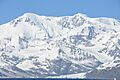
Mount Paget, the highest peak on South Georgia.
-
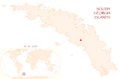
A map showing the location of Mount Paget on South Georgia.
See also
In Spanish: Monte Paget para niños
