Allardyce Range facts for kids

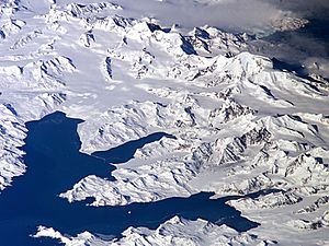
The Allardyce Range is a large group of mountains. It is located in the central part of South Georgia. South Georgia is a UK overseas territory.
This mountain range is found south of Cumberland Bay. It stretches for about 50 kilometers (31 miles). The range goes from Mount Globus in the northwest to Mount Brooker in the southeast.
Tall Peaks of the Allardyce Range
The mountains in the Allardyce Range are very tall. Their peaks reach heights of 2,000 to 2,935 meters (6,560 to 9,630 feet).
The highest point in the range is Mount Paget. It stands at 2,935 meters (9,630 feet) tall. Mount Paget is also the highest mountain in all of the UK's overseas territories. Another important peak in this range is Mount Roots.
History and Naming
Explorers like James Cook in 1775 and Fabian Gottlieb von Bellingshausen in 1819 likely saw these mountains. However, they were not shown on their maps.
The Allardyce Range got its name around 1915. It was named after Sir William Lamond Allardyce. He was an important leader. Sir William was the Governor of the Falkland Islands and their surrounding areas from 1904 to 1914.
See also
 In Spanish: Cordillera de San Telmo para niños
 | Kyle Baker |
 | Joseph Yoakum |
 | Laura Wheeler Waring |
 | Henry Ossawa Tanner |

