Cumberland Bay facts for kids

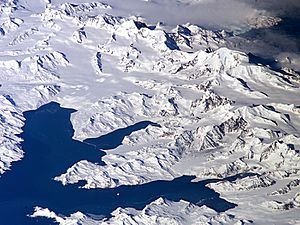
Cumberland Bay is a large bay on the northern coast of South Georgia. This island is located in the South Atlantic Ocean. The bay is about 4 miles (6.4 km) wide at its entrance. It is found between Larsen Point and Barff Point.
Cumberland Bay splits into two main parts. These are Cumberland West Bay and Cumberland East Bay. The bay stretches inland for about 9 miles (14.5 km). The famous British explorer James Cook discovered and named this bay in 1775.
Cumberland Bay in World War II
During the Second World War, many whaling stations in the area closed down. Only the stations at Grytviken and Leith Harbour remained open. Many British and Norwegian whaling ships were attacked. German merchant raiders, which were armed ships disguised as regular trading vessels, destroyed them. The remaining ships joined the Allied forces to help with the war effort.
Defending South Georgia
The British Magistrates, W. Barlas and A.I. Fleuret, were in charge of defending South Georgia during the war. The Royal Navy sent an armed merchant cruiser called the Queen of Bermuda to patrol the waters around South Georgia and Antarctica.
To protect important areas, two large four-inch guns were set up. One was placed at Grytviken to guard Cumberland Bay. The other was at Leith Harbour to protect Stromness Bay. These gun batteries can still be seen today. Norwegian whalers who volunteered were trained to operate these guns.
See also
 In Spanish: Bahía Cumberland (Georgia del Sur) para niños
 | May Edward Chinn |
 | Rebecca Cole |
 | Alexa Canady |
 | Dorothy Lavinia Brown |

